
Providing positioning assistance data

a technology of positioning assistance and data, applied in the field of assistance positioning, can solve the problems of satellite signal distortion on its way, signal quality may not be sufficiently high for decoding navigation messages, and the decoding of navigation messages requires a significant amount of processing power

Inactive Publication Date: 2011-02-10
NOKIA CORP
View PDF12 Cites 25 Cited by
  • Summary
  • Abstract
  • Description
  • Claims
  • Application Information

AI Technical Summary

Benefits of technology

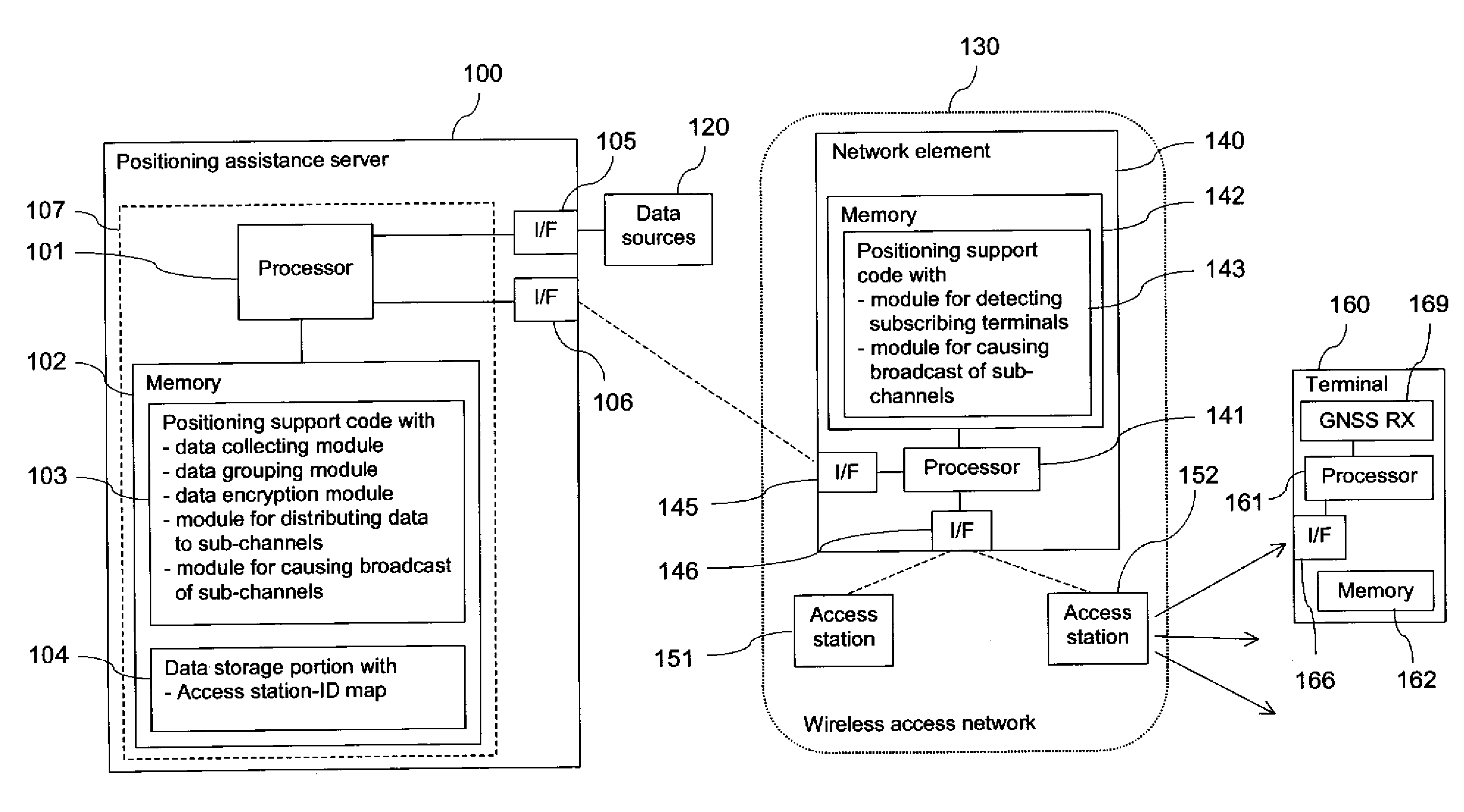
[0023]It would be possible, for example, to encrypt different kind of content of the broadcast using different keys, and thus to deliver differentiated assistance data—like different levels of assistance service—to different subscribers. A distribution of keys to the terminals could be related to, for instance, charging or geographical areas. Hence, service providers might obtain the possibility of building “assistance service packages” that might differ in performance characteristics or other characteristics. The subscribers can then, for instance, buy different levels of assistance service based on their needs. All the assistance data may still be available in the same broadcast, that is the broadcast does not have to be customized. Still, the data which the terminal actually retrieves from the broadcast may be highly customized, since it is the terminal that picks the relevant items from the broadcast. Such an embodiment may reduce hardware and software requirements, complexity and costs of a service provider providing the assistance data.
[0026]Such embodiments, which rely on broadcasts in the control plane, allow preventing the transmission of information unnecessarily in cells that do not have any users for the information. For example, in contrast to traditional broadcast, obtaining access to an IP broadcast may require registration to a particular service so that a corresponding determination of terminals may be supported.
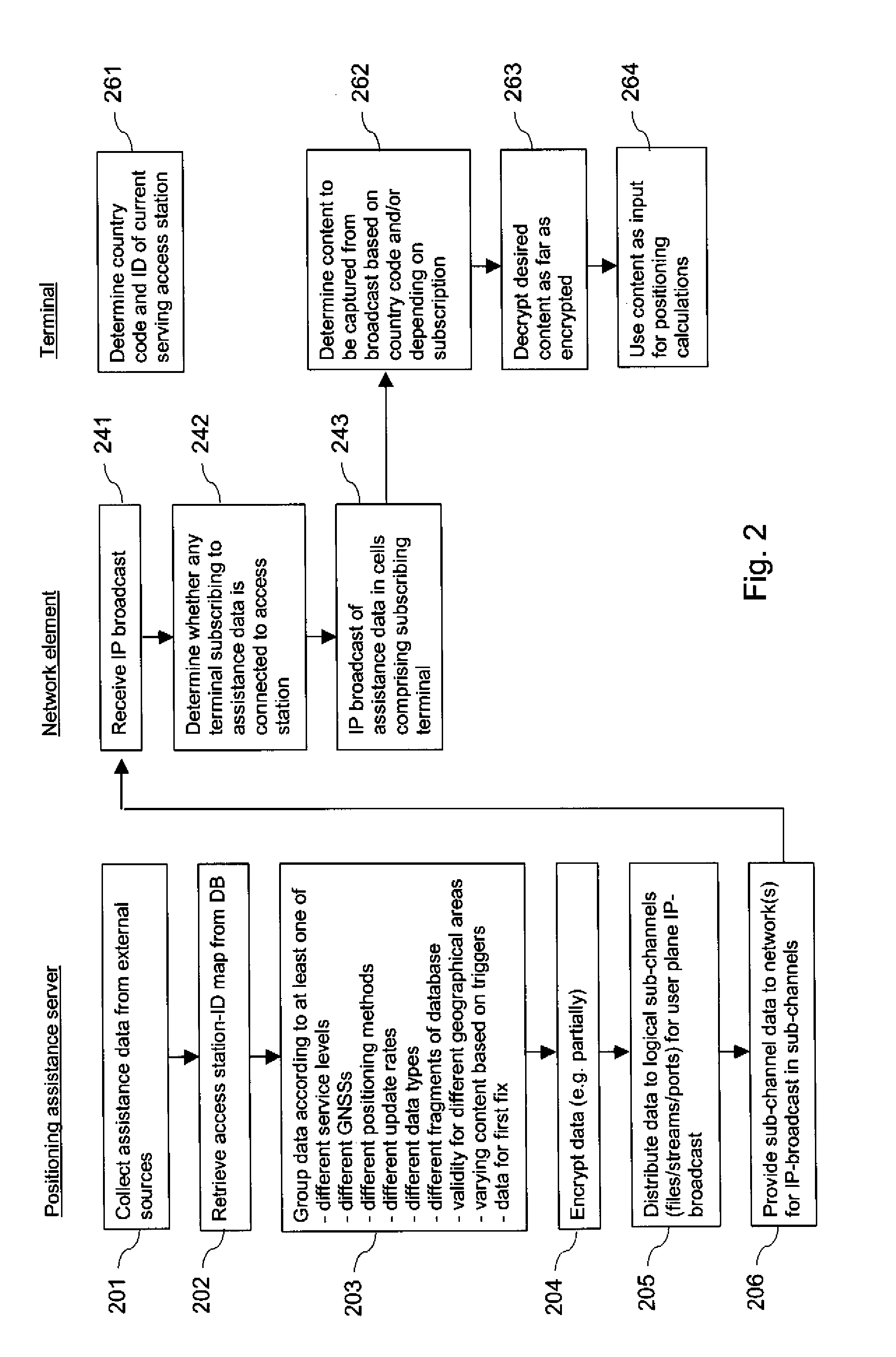
[0036]To present one example, during ionospheric storm it may be of advantage to update a ionospheric model, which is provided as assistance data, at a very high rate in order to ensure that the provided assistance data has the highest possible accuracy. Such high-update rate assistance may be delivered efficiently in a broadcast, since point-to-point deliveries would increase the network load significantly. Since the high-update rate may not be required constantly, the assistance data may further be provided at this high-update rate for instance in a sub-channel that is provided for varying assistance content. That is, this sub-channel may be used for delivering other content in the case of other triggers. In general, the broadcasting using sub-channels may enable dynamic scheduling of the broadcast content depending on various factors.
[0042]In one embodiment of the invention, the broadcast using a plurality of logical sub-channels is a broadcast in a user plane, using for example user plane data bearers. Compared to a broadcast in a control plane or management plane, for example, a broadcast in a user plane may have less bandwidth restrictions. Certain assistance data may require a high bandwidth, for instance three-dimensional ionosphere maps providing highly accurate corrections to GNSS measurements, or assistance data that is provided at high update rates. Further, terminals are not required to be in an idle state to receive user plane broadcasts. Further, broadcasts in the user plane may not suffer from a low priority due to some high priority messages, like system information and control messages that are transmitted in other planes.
[0047]The invention can further be used for providing any kind of positioning assistance data, in particular, though not exclusively, assistance data for a satellite signal based positioning. Such satellite signals may comprise satellite signals transmitted in a GNSS, like GPS, GLONASS, GALILEO, SEAS, QZSS, LAAS or a combination of these. LAAS makes use of pseudolites instead of true satellites, but these pseudolites are to be understood to be covered as well by the term satellite as used in this application. LAAS has the advantage that it enables a positioning under indoor conditions as well.

Problems solved by technology

Some of these methods may profit from the availability of assistance data.
In some environments, a GNSS receiver may be able to acquire and track sufficient satellite signals for a positioning based on the PRN codes, but the quality of the signals may not be sufficiently high for decoding the navigation messages.
Further, the decoding of navigation messages requires a significant amount of processing power, which may be limited in a mobile GNSS receiver.
Moreover, a satellite signal is distorted on its way from a satellite to a receiver due to, for instance, multipath propagation and due to influences by ionosphere and troposphere.
While the GNSS satellites may transmit ionosphere models for correcting the signals accordingly, the provided models may be not very accurate or up-to-date.

Method used


Image

  • Providing positioning assistance data
  • Providing positioning assistance data
  • Providing positioning assistance data

Examples


Embodiment Construction

[0013]A method is described which comprises causing a broadcast of positioning assistance data in a plurality of different logical sub-channels. The positioning assistance data has been distributed to the plurality of different logical sub-channels depending on its content.

[0014]Moreover, a first apparatus is described, which comprises a processor configured to cause a broadcast of positioning assistance data in a plurality of different logical sub-channels, wherein the positioning assistance data has been distributed to the plurality of different logical sub-channels depending on its content.

[0015]The apparatus may comprise for example exclusively the described processor, but it may also comprise additional components. The apparatus could further be for example a module provided for integration into a device, like a processing component, a chip or a circuit implementing the processor, or it could be such a device itself. In the latter case, it could be for instance a server, which ...


PUM


Abstract

For supporting the use of positioning assistance data, the positioning assistance data is broadcast in a plurality of different logical sub-channels. The positioning assistance data is distributed to the plurality of different logical sub-channels depending on its content.

Description

FIELD OF THE INVENTION[0001]The invention relates in general to the field of assisted positioning. More particularly, the invention relates to the provision of positioning assistance data.BACKGROUND OF THE INVENTION[0002]A position of a device can be determined by means of various positioning methods. Some of these methods may profit from the availability of assistance data.[0003]A positioning of a device is supported for instance by various Global Navigation Satellite Systems (GNSS). These include for example the American Global Positioning System (GPS), the Russian Global Navigation Satellite System (GLONASS), the future European system Galileo, the Space Based Augmentation Systems (SBAS), the Japanese GPS augmentation Quasi-Zenith Satellite System (QZSS), the Locals Area Augmentation Systems (LAAS), and hybrid systems.[0004]The constellation in GPS, for example, consists of more than 20 satellites that orbit the earth. Each of the satellites transmits two carrier signals L1 and L...

Claims


Application Information

Patent Timeline
IPC IPC(8): H04W40/00
CPCG01S19/05Y10S707/922Y10S707/919G01S19/258
Inventor WIROLA, LAURIHALIVAARA, ISMOSYRJARINNE, JARI
Owner NOKIA CORP
Learn More