Precise positioning using a distributed sensor network

a distributed sensor network and precise positioning technology, applied in direction finders, direction finders using radio waves, instruments, etc., can solve the problems of poor accuracy, difficult locating, and precise positioning of underground infrastructur

Active Publication Date: 2011-06-30
OPTIMAL RANGING
View PDF15 Cites 68 Cited by
  • Summary
  • Abstract
  • Description
  • Claims
  • Application Information

AI Technical Summary

Problems solved by technology

Precise positioning, locating, and tracking of underground infrastructure is difficult under many circumstances, especially in dense urban environments, where buried or obscured pipes and other utilities are co-located in conduits within constrained rights-of-way.
Lower frequency ranges are used for signal strength measurements, but poor accuracy results for situations when there are obstructions in the signal path between transmitter and receiver.

Method used


Image

  • Precise positioning using a distributed sensor network
  • Precise positioning using a distributed sensor network
  • Precise positioning using a distributed sensor network

Examples


Embodiment Construction

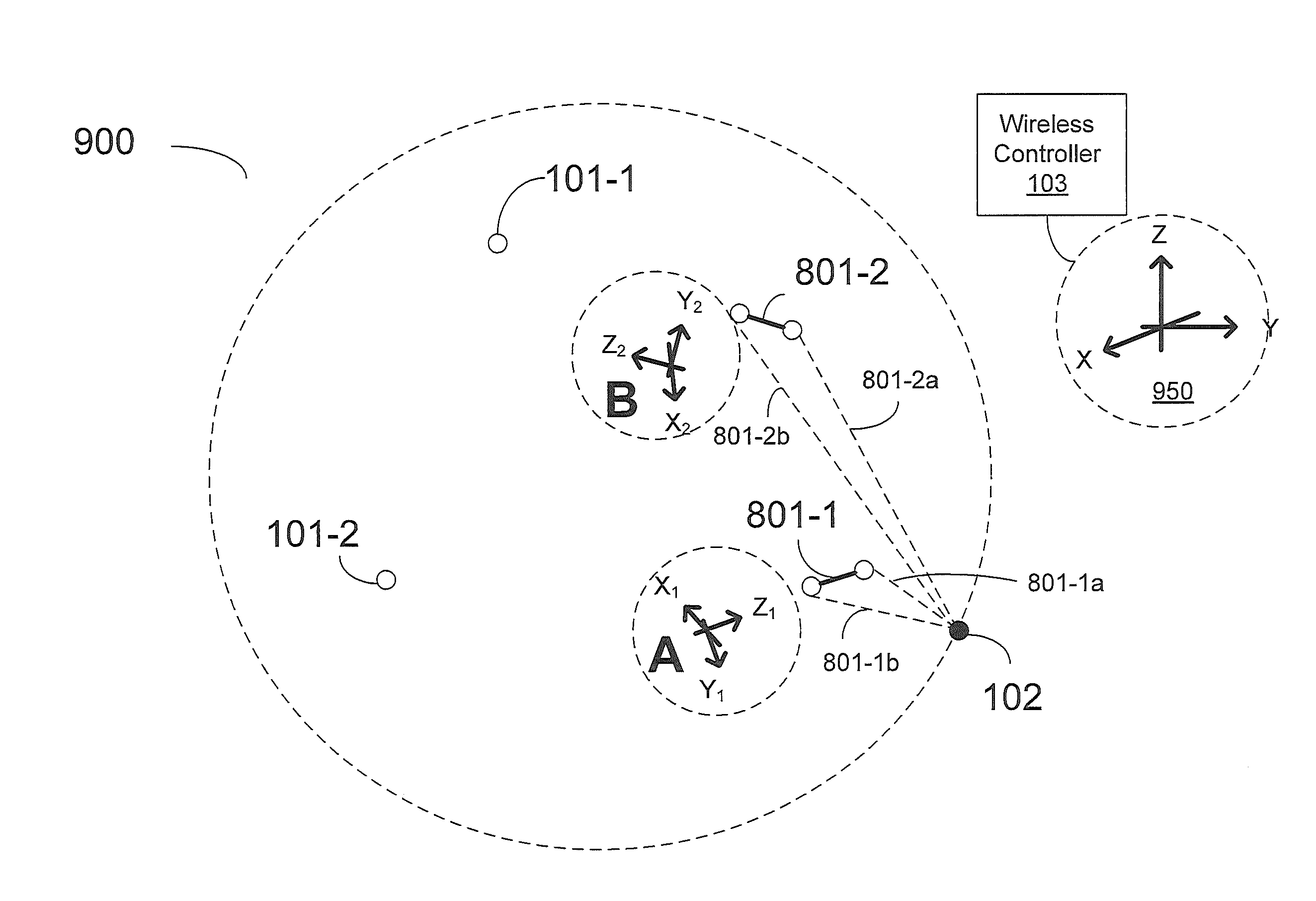
[0026]Precise location technology is based on the optimization of data from many sensors against a physical model of the magnetic field expected from a utility line or dipole antenna. The method eliminates the need to bring the measurement equipment to specific points related to the utility cable or pipe in order to validate position. Legacy instruments find the “peak” or “null” in the signal in order to confirm pipeline or cable position. Using the precise location method, the equipment need only be in the approximate vicinity to calculate position with corresponding confidence bounds. Using three-dimensional (3-d) magnetic field sensors, a triaxial accelerometer and digital compass, the method identifies the offset, depth, range, current, and yaw angle to the underground utility regardless of its position in the radiated field. In combination with a professional global navigation satellite system (GNSS), the utility position can be automatically geo-referenced in real-time, even w...


PUM


Abstract

A method for determining the location and orientation of a transmitter object by measuring a set of complex electromagnetic field magnitude and phase strengths within a space using one or more receivers is provided. The method includes modeling a set of expected complex electromagnetic strengths to estimated position and orientation of the transmitter object. And estimating parameters related to the transmitter object position based on the residual error between the measured set of complex electromagnetic field values and a set of expected electromagnetic field values. Further embodiments include a method as above including a plurality of receivers with known positions within a limited space including the transmitter object. A sensor network including a plurality of receivers to perform the above method is also provided. The receivers may communicate using a wireless channel.

Description

RELATED APPLICATIONS[0001]This application claims priority to Provisional Application No. 61 / 291,602, entitled “Precise Positioning in a Multiple Dipole Field,” by James W. Waite, Kun Li, Johan Overby, Dimitar Gargov, Philip Desjardins, and Thorkell Gudmundsson, filed on Dec. 31, 2009, the contents of which are hereby incorporated by reference in their entirety.BACKGROUND[0002]1. Field of the Invention[0003]Some embodiments of this invention relate to the field of precise location of concealed objects and linear utility conveyances, and, in particular, to precise positioning using a distributed sensor network.[0004]2. Discussion of Related Art[0005]Precise positioning, locating, and tracking of underground infrastructure is difficult under many circumstances, especially in dense urban environments, where buried or obscured pipes and other utilities are co-located in conduits within constrained rights-of-way. In those areas, active dipole transmitters, sometimes known as ‘sondes,’ ma...

Claims


Application Information

Patent Timeline
Patent Type & Authority Applications(United States)
IPC IPC(8): G01S5/02G06F19/00
CPCG01S5/0221G01S5/0226G01V3/081G01S5/0252G01S5/0247G01S5/02213
Inventor WAITE, JAMES W.GUDMUNDSSON, THORKELLGARGOV, DIMITAR
Owner OPTIMAL RANGING
Why Eureka
Try Eureka