Method and device of satellite navigation system's integrity control

a technology of integrity control and satellite navigation, applied in the field of space exploration, can solve the problems of system integrity control results, high cost of global allocation and maintenance of control stations, and inability to meet requirements

Active Publication Date: 2011-08-25
JOINT CO RUSSIAN SPACE SYST JSC RSS
View PDF3 Cites 0 Cited by
  • Summary
  • Abstract
  • Description
  • Claims
  • Application Information

AI Technical Summary

Benefits of technology

[0011]The technical result is achieved due to the fact that the method of GNSS navigation field integrity control assumes the check of navigation signal's digital data, insertion of uncertainty flag into the navigation signal, determination of estimated pseudo-range up to the other GNSS reference satellites, by each GNSS satellite, determination of discrepancies of pseudo-range measurements, determination of compliance of measurement discrepancies with targeted tolerance and logging by each satellite the navigation signal's uncertainty flag into digital data of the own navigation signal.
[0012]Besides, the satellites to be used as the reference ones are located within the visibility zone of the ground control segment. As the reference satellites the opposed satellites are used. The discrepancies in measurements of pseudo-ranges up to the other GNSS reference satellites shall be determined by each satellite of the GNSS at every current second. Measurement of the pseudo-range to selected reference satellites shall be accomplished sequentially or concurrently on the basis of system's almanac (SA) or in accordance with the program laid by the ground control segment.
[0013]For the purpose of realizing the method of the GNSS system's integrity control each satellite contains a transmitter-receiver unit, a computer, a navigation signal generator, a source of navigation signal, a pseudo-range measuring instrument, an unit for calculation of pseudo-range to the other reference GNSS satellites, an unit for comparison of estimated pseudo-range with the measured one, a control unit, a decision making unit, whereas the first output of the transmitter-receiver facility is connected with the input of the control unit, the second output of the transmitter-receiver facility is connected with the input of computer, the I/O of which is connected with the unit for calculation of pseudo-range to the other reference satellites, the computer's output is connected with the first inpu

Problems solved by technology

However, these control means are placed at the RF territory only and they are not accessible for the satellites being not visible from the Russian territory, therefore, they are unable to meet the requirement concerning the rapidity of introducin

Method used


Image

  • Method and device of satellite navigation system's integrity control
  • Method and device of satellite navigation system's integrity control
  • Method and device of satellite navigation system's integrity control

Examples


Embodiment Construction

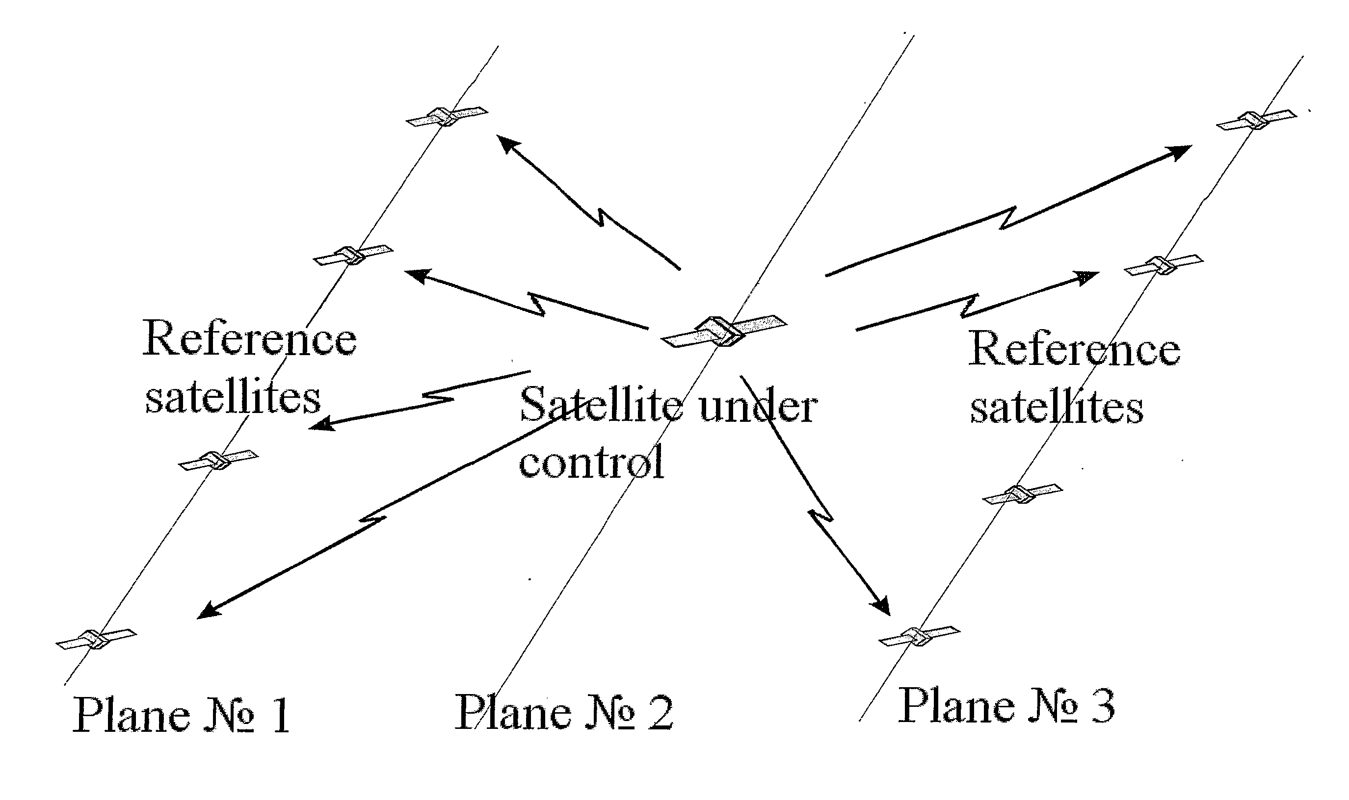
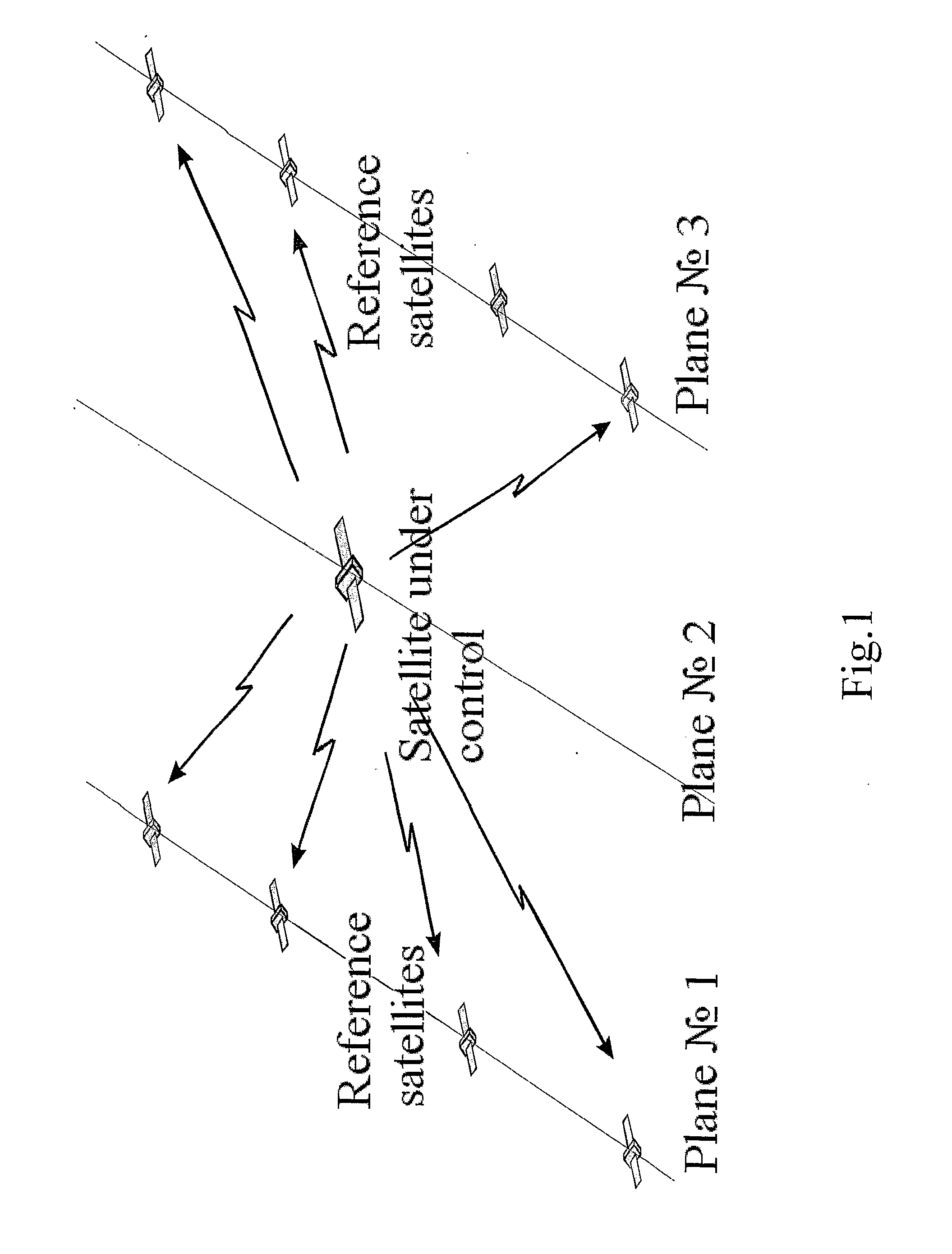
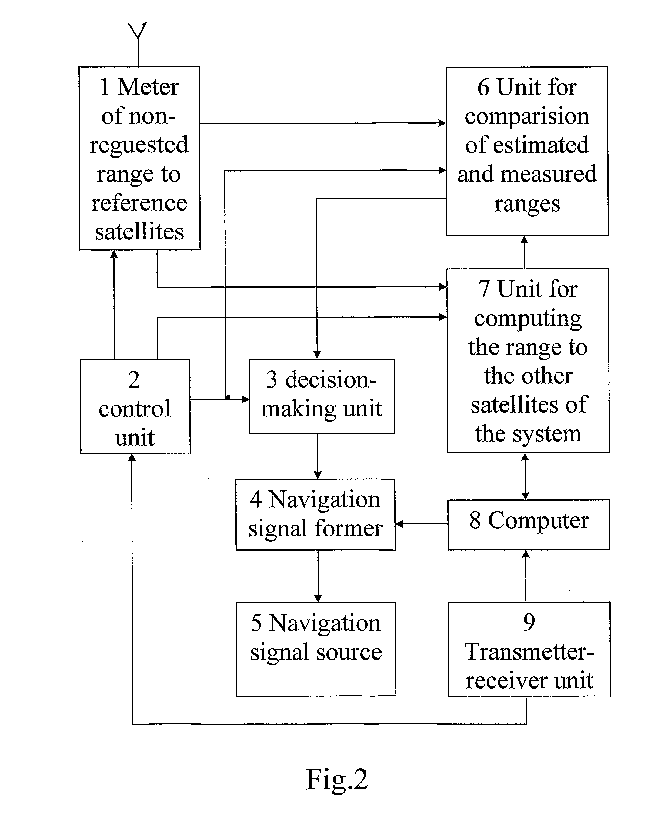
[0031]The essence of the technical solution lies in that each navigation satellite determines independently the integrity of its own radiated navigation signal.

[0032]An uncertainty can be caused by inadequate digital information in the navigation signal, its discordancee with the real state of the satellite or unauthorized breach of on-board frequency standard's stability.

[0033]The integrity shall be determined by estimating the value of navigation signal's discrepancies (comparison of pseudo-range estimated value with the measured one) for each satellite of the system relative to the other satellites.

[0034]When the value of discrepancy of pseudo-range measurement made by one satellite and measurements made by several other satellites of the system exceeds the target tolerance, it witnesses, that this satellite radiates an invalid (uncertain) navigation signal and lay down the uncertainty flag in its navigation frame.

[0035]As long as each satellite of the system performs the said op...


PUM


Abstract

This invention relates to domain of space activity and can be used for the Earth satellite aided radio navigation, particularly, for control (monitoring) the system integrity without attendance of means of the ground control complex and globally allocated reference stations. A technical result of the claimed technical solution is the responsiveness enhancement of a user's notification about navigation signal uncertainty; cutting-down of expenditures for solving the task of system's integrity control considering the lack of globally allocated ground-based control and monitoring complexes; elimination of additional radio links; increase of reliability of the system's integrity control, growth of reliability. The device for realizing the method of navigation satellite system's integrity control comprises a transmitter-receiver unit, a computer, a navigation signal generator, a navigation signal source, a range measuring instrument, an unit for computing the range to other reference satellites of the navigation satellite system, an unit for comparison of estimated range with the measured one, control unit and decision-making unit.

Description

FIELD OF INVENTION[0001]The present invention relates to the area of space exploration and can be used for satellite aided radio navigation, in particular, for the system integrity control operating without attendance of ground control segment's facilities and globally allocated control stations.STATE OF THE ART[0002]A time allowance has been established for the GLONASS system between the moment of appearing an inconsistency of the satellite's digital information with the true state of satellite and the moment of notifying the navigation signal's user about this signal inconsistency.[0003]This time allowance amounts to units of seconds independently on the satellite's location.[0004]The procedure of uncertainty determination in itself is adopted to be called as the system integrity control. The ground-based control segments incorporate the control means intended to determine the navigation signal integrity and to record the uncertainty flag to the satellite. However, these control m...

Claims


Application Information

Patent Timeline
IPC IPC(8): G01S19/20
CPCG01S19/20
Inventor URLICHICH, YURY MATEVICHNEMTSEV, VYACHESLAV IVANOVICHKRUGLOV, ALEXANDER VICTOROVICH
Owner JOINT CO RUSSIAN SPACE SYST JSC RSS
Why Eureka
Try Eureka