Methods, apparatuses and computer program products for converting a geographical database into a map tile database

Inactive Publication Date: 2012-06-21
PIECE FUTURE PTE LTD
View PDF4 Cites 15 Cited by
  • Summary
  • Abstract
  • Description
  • Claims
  • Application Information

AI Technical Summary

Benefits of technology

[0012]By creating and using an index with integer-type columns (e.g., xmin, ymin, xmax, ymax) for retrieving tile geographical data, an example embodiment may facilitate the use of a geographic database(s) without the usual requirement of spatial database management systems (e.g. PostgreSQL).
[0017]By utilizing an example embodiment, the usual tile size tradeoff problems encountered by current tile-indexing schemes may be alleviated. In this regard, an example embodiment may allow convenient translation of a query for a tile at any zoom level into a query for the relevant tiles at the zoom level that was used to transform the geographical database and may then retrieve the relevant geographical data from the geographical database.
[0018]An example embodiment of the invention may utilize smaller indexes which may translate to faster record retrieval times. As such, an example embodiment may yield better database performance. This, in turn, may enhance the overall performance of network devices (e.g., a server) that may enable provision of map services which may render map tiles as well as perform other map-based services that may be based on geographical databases such as, for example, retrieving and rendering live traffic data on a map. As such, an example embodiment may yield better database performance for map servers. For instance, an example embodiment may generate a tile index for the Navteq™ streets database that may use a memory (e.g., disk space) of 806 MB, which is an improvement over existing approaches. Additionally, an example embodiment may also improve response times to requests by a client (e.g., a mobile terminal) for location or map data.
[0020]In another example embodiment, an apparatus for converting geographical geometrical content of a geographical database to map tiles is provided. The apparatus may include a processor and a memory including computer program code. The memory and computer program code are configured to, with the processor, cause the apparatus to at least perform operations including modifying a geographical database based in part on adding items of data arranged in fields based on analyzing values corresponding to geometry information associated with geographical records of the geographical database. The computer program code may further cause the apparatus to determine a set of tiles, for each of the records, at a predetermined zoom level that includes at least a portion of the geographical information of respective records and updating each of the records to include data associated with minimum and maximum x and y values of the tiles that correspond to the geometrical information of a corresponding record. The computer program code may further cause the apparatus to determine that the minimum and maximum x and y values define one or more rectangular blocks of map tiles.
[0022]Embodiments of the invention may enhance cost efficiencies related to overhead in computing storage and processing associated with tile indexes of geographical databases. In this manner, an example embodiment may reduce the size of geographical data stored in a geographical database which may enable faster data retrieval. As such, mobile terminal users may enjoy improved mobile device functionality.

Problems solved by technology

While this approach may provide good performance for data retrieval with respect to mapping systems, it may also incur high overhead in computing storage costs and computing processing costs.
As such, one drawback with this approach of geometric data retrieval is that it may result in heavy use of computing storage resources (e.g., disk and memory) and processing resources for tile indexes.
This is a huge amount of space overhead especially in consideration of the size of the database itself.
To resolve the disk space issue, existing tile-indexing systems typically make tile size tradeoffs when indexing geographical data.
However, using smaller tiles in this manner typically requires large amounts of disk space to maintain the resulting indexes.
For instance, smaller tiles may result in more segment traversals requiring more space to be used.
On the other hand, larger tiles at lower zoom levels typically contain large amounts of geographical data per tile and thus may have worse selectivity for queries requesting map data than smaller tiles.
However, larger tiles typically require smaller amounts of disk space to maintain the resulting indexes.
For instance, at zoom level 9, the disk space for leaf index nodes is only about one megabyte (MB) but may result in poor performance for tile requests at zoom level 18, for instance, because the query for map data may typically return a large number of records as there are 218 (over 260,000 tiles) zoom 18 tiles contained in each zoom 9 tile.

Method used


Image

  • Methods, apparatuses and computer program products for converting a geographical database into a map tile database
  • Methods, apparatuses and computer program products for converting a geographical database into a map tile database
  • Methods, apparatuses and computer program products for converting a geographical database into a map tile database

Examples


Embodiment Construction

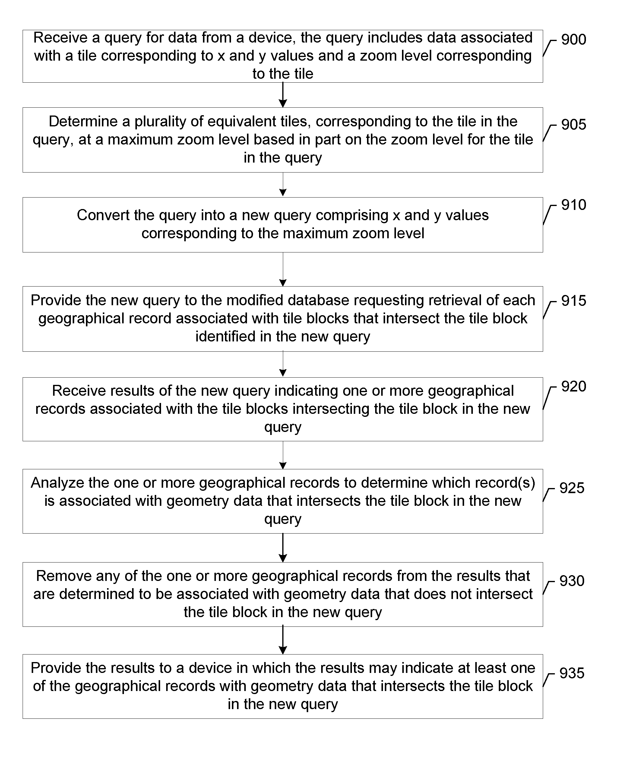
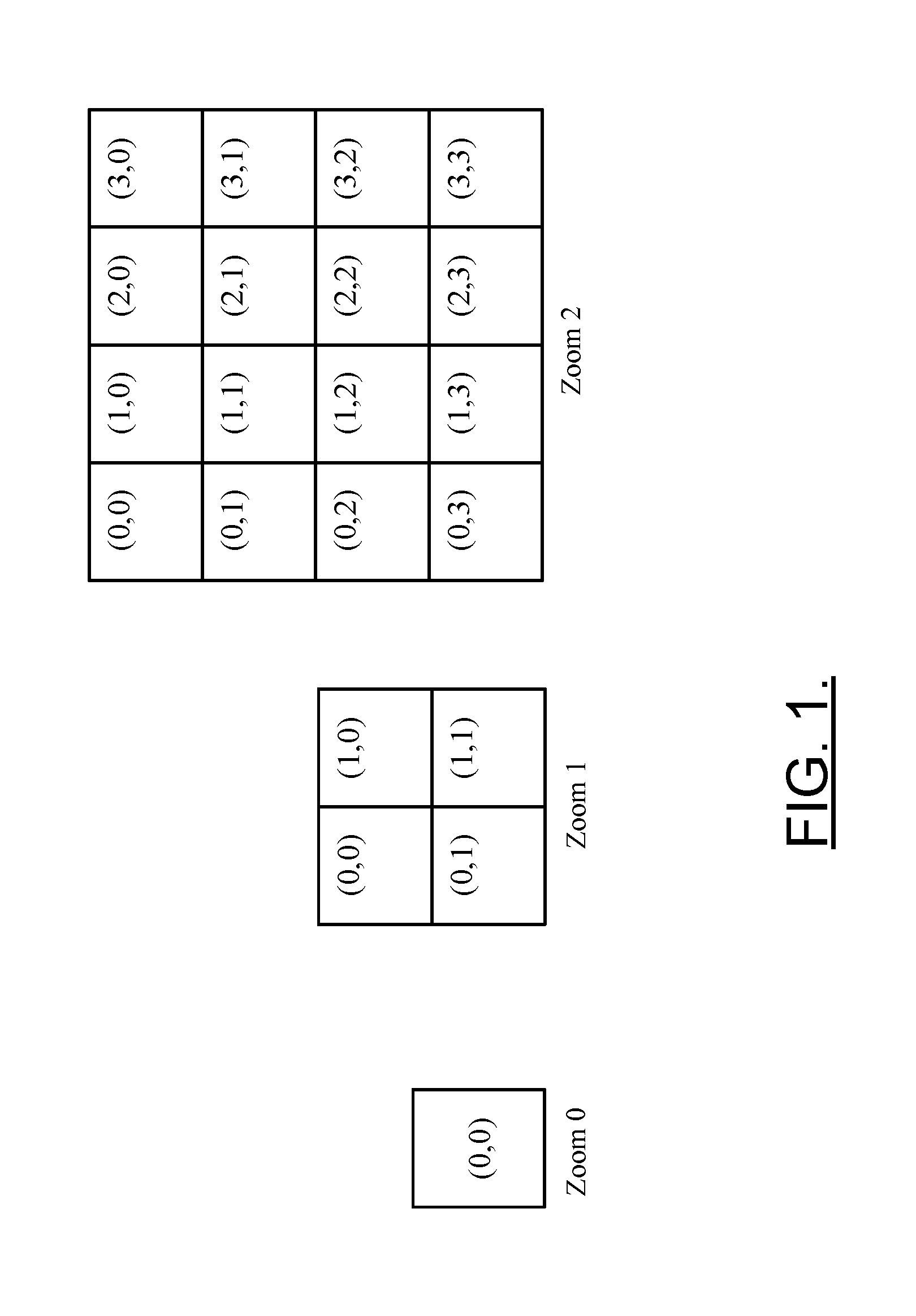
[0033]Some embodiments of the present invention will now be described more fully hereinafter with reference to the accompanying drawings, in which some, but not all embodiments of the invention are shown. Indeed, various embodiments of the invention may be embodied in many different forms and should not be construed as limited to the embodiments set forth herein. Like reference numerals refer to like elements throughout. As used herein, the terms “data,”“content,”“information” and similar terms may be used interchangeably to refer to data capable of being transmitted, received and / or stored in accordance with embodiments of the present invention. Moreover, the term “exemplary”, as used herein, is not provided to convey any qualitative assessment, but instead merely to convey an illustration of an example. Thus, use of any such terms should not be taken to limit the spirit and scope of embodiments of the present invention.

[0034]Additionally, as used herein, the term ‘circuitry’ refer...


PUM


Abstract

An apparatus for converting geographical geometrical content of a geographical database to map tiles may include a processor and a memory storing executable computer code that cause the apparatus to at least perform operations including modifying a geographical database based in part on adding items of data arranged in fields based on analyzing values corresponding to geometry information. The geometry information is associated with records of the geographical database. The computer program code may further cause the apparatus to determine a set of tiles at a predetermined zoom level including geographical information of respective records and may update the records to include data associated with minimum and maximum x and y values of the tiles. The computer program code may further cause the apparatus to determine minimum and maximum x and y values that define a rectangular block(s) of map tiles. Corresponding computer program products and methods are also provided.

Description

TECHNOLOGICAL FIELD[0001]An embodiment of the invention relates generally to database technology and more particularly relates to a method, apparatus and computer program product for optimizing a database to improve database performance for retrieval of location or map data by converting a geographic database into a map tile database.BACKGROUND[0002]The modern communications era has brought about a tremendous expansion of wireline and wireless networks. Computer networks, television networks, and telephony networks are experiencing an unprecedented technological expansion, fueled by consumer demand. Wireless and mobile networking technologies have addressed related consumer demands, while providing more flexibility and immediacy of information transfer.[0003]Current and future networking technologies continue to facilitate ease of information transfer and convenience to users. Due to the now ubiquitous nature of electronic communication devices, people of all ages and education leve...

Claims


Application Information

Patent Timeline
IPC IPC(8): G06F17/30
CPCG06F17/30241G06F16/29G06F3/048G06F16/23G06F16/245
Inventor IWUCHUKWU, TOCHUKWU
Owner PIECE FUTURE PTE LTD
Why Eureka
Try Eureka