Hybrid deterministic-geostatistical earth model

Active Publication Date: 2013-02-28
CHEVROU USA INC
View PDF10 Cites 36 Cited by
  • Summary
  • Abstract
  • Description
  • Claims
  • Application Information

AI Technical Summary

Benefits of technology

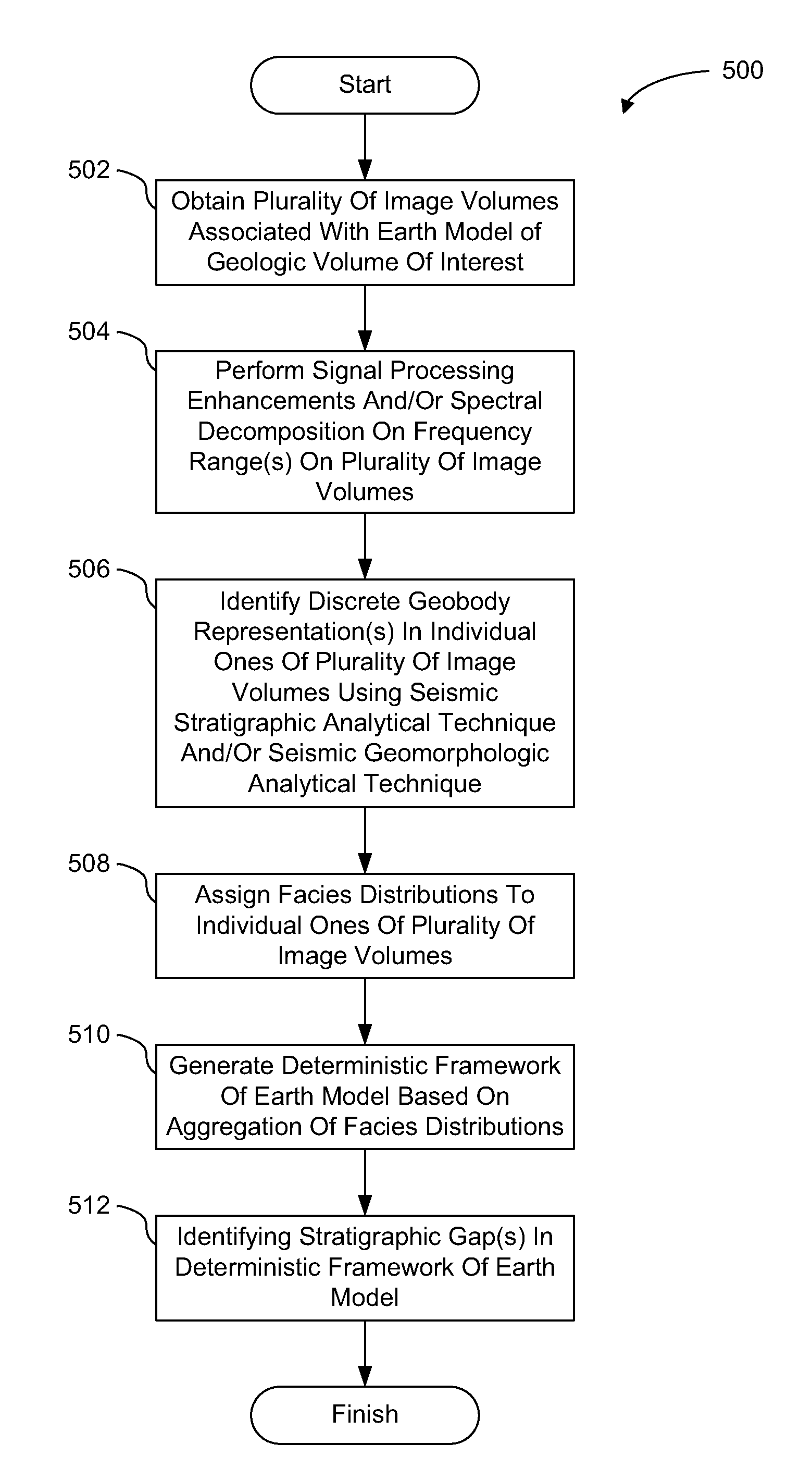
[0004]One aspect of the disclosure relates to a computer-implemented method for generating a deterministic framework for earth models through deterministic identification of discrete geobodies. The method includes obtaining a plurality of image volumes associated with an earth model of a geologic volume of interest that includes one or more geobodies. The earth model is based on seismic data representing energy that has propagated through the geologic volume of interest from one or more energy sources to one or more energy receivers. The seismic data includes one or more of at least one offset stack, at least one angle stack, or at least one azimuth stack. Individual ones of the plurality of image volumes correspond to different stack domains. The method includes performing one or both of signal processing enhancements or spectral decomposition on one or more frequency ranges on the plurality of image volumes associated with the earth model of the geologic volume of interest. The method includes identifying one or more discrete geobody representations in individual ones of the plurality of image volumes by analyzing one or more of the plurality of image volumes using one or both of a seismic stratigraphic analytical technique or a seismic geomorphologic analytical technique. Individual ones of the one or more geobody representations correspond to the one or more geobodies included in the geologic volume of interest. The method includes assigning facies distributions to individual ones of the plurality of image volumes. The facies distributions include spatially descriptive values and/or rock properties assigned to the identified one or more geobody representations based on one or both of borehole data and/or geophysical modeling. The method includes generating a deterministic framework of the earth model based on an aggregation of the facies distributions. The deterministic framework is a matrix associated with the earth model that extends over some or the entire earth model and includes individual ones of the identified one or more geobody representations and one or more undefined regions. The method includes identifying one or more stratigraphic gaps in the deterministic framework of the earth model. The one or more stratigraphic gaps are devoid of identified geobody representations.
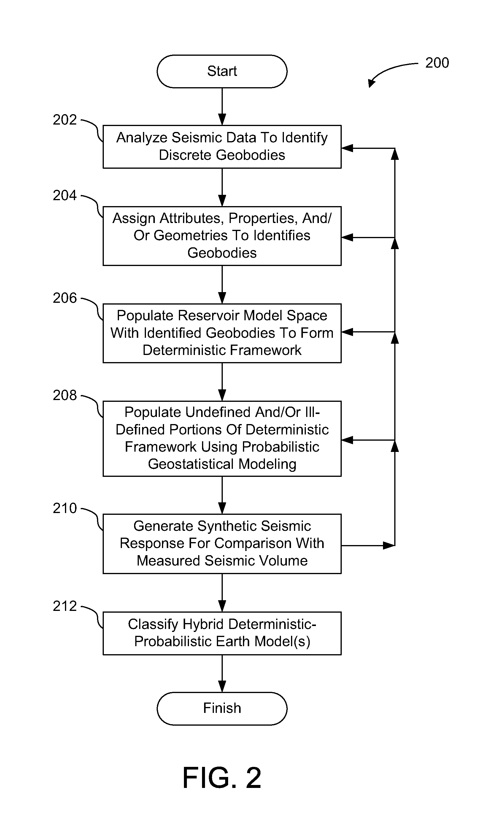
[0005]Another aspect of the disclosure relates to a computer-implemented method for generating hybrid deterministic-geostatistical earth models by filling stratigraphic gaps in deterministic frameworks using geostatistical information and/or seismic inversion. The method includes obtaining a deterministic framework associated with an earth model of a geologic volume of interest that includes one or more geobodies. The earth model is based on measured seismic data representing energy that has propagated through the geologic volume of interest from one or more energy sources to one or more energy receivers. The measured seismic data includes one or more of at least one offset stack, at least one angle stack, or at least one azimuth stack. The deterministic framework is a matrix associated with the earth model that extends over some or the entire earth model. The method includes identifying a set of one or more geobody representations associated with the geologic volume of interest. Individual ones of the geobody representations in the set are stochastically derived and represent individual ones of the one or more geobodies included in the geologic volume of interest. The set of one or more geobody representations is constructed based on geostatistical methodology using one or both of borehole data or interpreted dynamic production data. The method includes generating an initial hybrid deterministic-geostatistical earth model by filling one or more stratigraphic gaps in the deterministic framework of the earth model with individual ones of the geobody representations in the set. Individual ones of the one or more stratigraphic gaps are regions of the deterministic framework that are devoid of geobody representations. The method includes generating a synthetic seismic response of the initial hybrid deterministic-geostatistical earth model for comparison with the measured seismic data. The comparison facilitates validation of the initial hybrid deterministic-geostatistical earth model. The method includes iteratively refining the initial hybrid deterministic-geostatistical earth model to obtain a set of final hybrid deterministic-geostatistical earth models. The refining is based on successive comparisons between the geologic seismic response and synthetic seismic responses of refined hybrid deterministic-geostatistical earth models. A synthetic seismic response of individual ones of the set of final hybrid deterministic-geostatistical earth model approximates the measured seismic data. The method includes selecting a representative hybrid deterministic-geostatistical earth model from among the set of final hybrid deterministic-geostatistical earth models. The representative hybrid deterministic-geostatistical earth model has a range of uncertainties based on one or more of at least one reservoir parameter or geological plausibility.
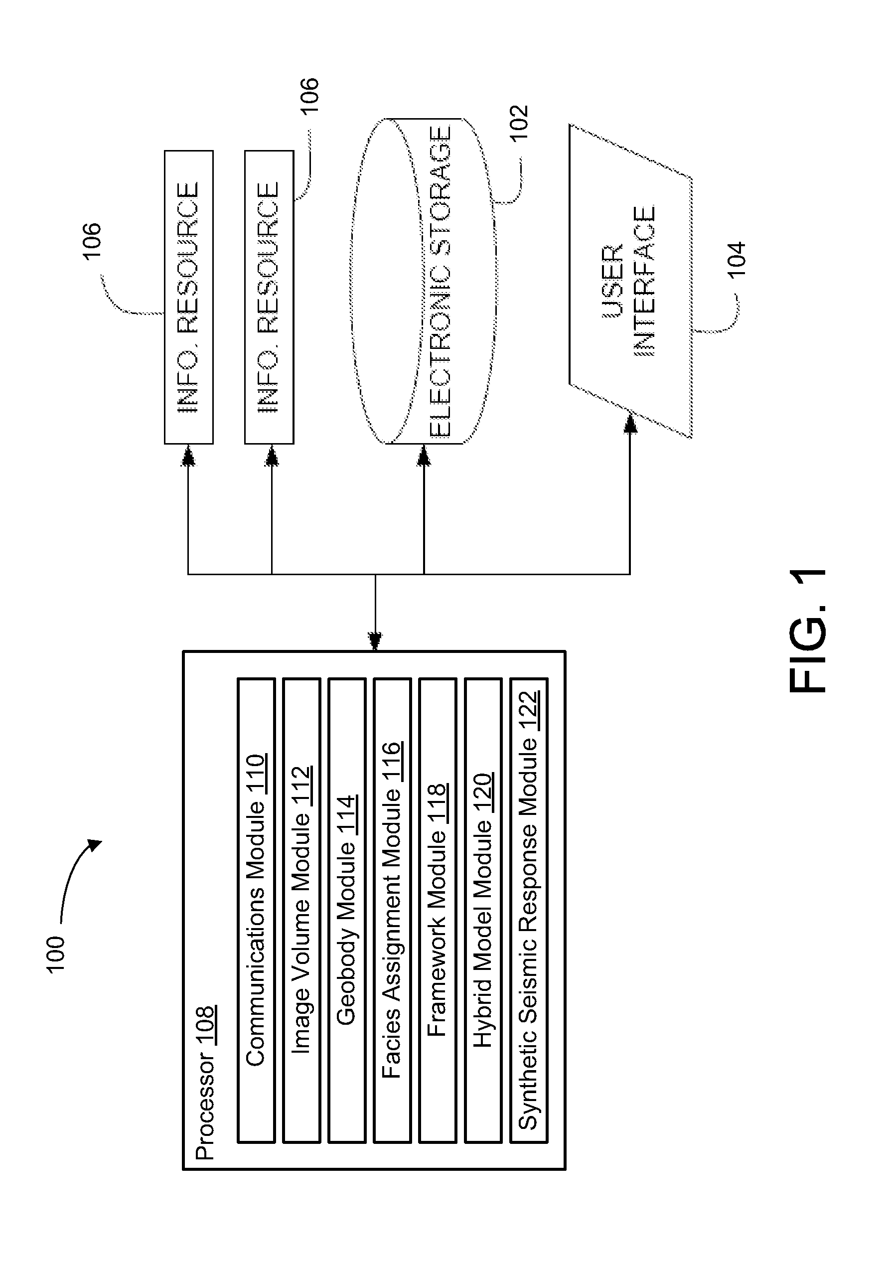
[0006]Yet another aspect of the disclosure relates to a system configured to generate a deterministic framework for earth models and to generate hybrid deterministic-geostatistical earth models. The system includes one or more processors configured to execute computer program modules. The computer program modules include an image volume module, a geobody module, a facies assignment module, a framework module, a hybrid model module, and a synthetic seismic response module. The image volume module is configured to generate or obtain a plurality of image volumes associated with an earth model of a geologic volume of interest that includes one or more geobodies. The earth model is based on seismic data representing energy that has propagated through the geologic volume of interest from one or more energy sources to one or more energy receivers. The seismic data includes one or more of at least one offset stack, at least one angle stack, or at least one azimuth stack. Individual ones of the plurality of image volumes correspond to different stack domains. The geobody module is configured to identify one or more discrete geobody representations in individual ones of the plurality of image volumes by analyzing one or more of the plurality of image volumes using one or both of a seismic stratigraphic analytical technique or a seismic geomorphologic analytical technique. Individual ones of the one or more geobody representations correspond to the one or more geobodies included in the geologic volume of interest. The facies assignment module is configured to assign facies distributions to individual ones of the plurality of image volumes. The facies distributions include spatially descriptive values and/or rock properties assigned to the identified one or more geobody representations based on one or both of borehole data and/or geophysical modeling. The framework module is configured to generate or obtain a deterministic framework of the earth model based on an aggregation of the facies distributions. The deterministic framework is a matrix associated with the earth model that extends over some or all of the earth model and including individual ones of the identified one or more geobody re

Problems solved by technology

Conventional industry workflows have limited reconciliation/integration of earth models used in imaging with interpretation of structure and stratigraphy, and with reservoir properties from seismic estimation.
Each process step has inherent uncertainties and non-uniqueness that cannot be well defined qua

Method used


Image

  • Hybrid deterministic-geostatistical earth model
  • Hybrid deterministic-geostatistical earth model
  • Hybrid deterministic-geostatistical earth model

Examples


Embodiment Construction

[0016]The present technology may be described and implemented in the general context of a system and computer methods to be executed by a computer. Such computer-executable instructions may include programs, routines, objects, components, data structures, and computer software technologies that can be used to perform particular tasks and process abstract data types. Software implementations of the present technology may be coded in different languages for application in a variety of computing platforms and environments. It will be appreciated that the scope and underlying principles of the present technology are not limited to any particular computer software technology.

[0017]Moreover, those skilled in the art will appreciate that the present technology may be practiced using any one or combination of hardware and software configurations, including but not limited to a system having single and / or multi-processer computer processors system, hand-held devices, programmable consumer el...


PUM


Abstract

Embodiments of the present technology integrate seismic data and geologic concepts into earth model building. More specifically, exemplary embodiments provide new ways to build an earth model based on information in the seismic data and geologic concepts to use as a context to interpret the seismic data and/or to add to the earth model in regions where the seismic data is missing (e.g., either no data or no data resolvability). In some embodiments, a deterministic framework is generated for an earth models through deterministic identification of discrete geobodies. A hybrid deterministic-geostatistical earth model is generated by filling stratigraphic gaps in a deterministic framework using geostatistical information and/or seismic inversion, in accordance with some embodiments.

Description

FIELD OF THE DISCLOSURE[0001]This disclosure generally relates to modeling a geologic volume of interest and, more specifically, to generating a hybrid deterministic-geostatistical earth model.BACKGROUND OF THE DISCLOSURE[0002]Seismic imaging and subsurface interpretation are performed to obtain, as accurately as possible, a geologic model of a subsurface volume of the earth. Conventional industry workflows generally include the following serial process steps: (a) process the seismic data into 3D seismic image volumes of the subsurface volume of the earth; (b) extract attributes (e.g., velocity, Poisson's ratio, density, acoustic impedance, etc.) at each subsurface point in the subsurface volume of the earth using tabulated and other known petrophysical data and rock properties; (c) interpret the geometry of the 3D seismic image volumes, log information, and geological analogs on an interpretation workstation to obtain the structure, stratigraphic, and geologic morphology; and (d) c...

Claims


Application Information

Patent Timeline
IPC IPC(8): G06F17/10G06K9/00G06F30/13G06F30/20
CPCG01V2210/665G01V99/005
Inventor POSAMENTIER, HENRY W.VU, CUNG KHACDISIENA, JAMES P.DYGERT, TODD
Owner CHEVROU USA INC
Why Eureka
Try Eureka