Deployable intelligence and tracking system for homeland security and search and rescue

a tracking system and homeland security technology, applied in the direction of direction finders, instruments, measurement devices, etc., can solve the problems of gps guidance systems being susceptible to jamming, affecting the positioning of sensors, and requiring expensive five-element null-steering antennas in guidance systems

Active Publication Date: 2013-04-18
ERA AS
View PDF0 Cites 51 Cited by
  • Summary
  • Abstract
  • Description
  • Claims
  • Application Information

AI Technical Summary

Problems solved by technology

However, terrestrial-based forms of tracking traditionally suffer over large water areas, which constrains the positioning of sensors.
However, GPS guidance systems are susceptible to jamming, such as via jamming transmitters located near the target.
In addition, GPS / inertial guidance systems often employ an expensive five element null-steering antenna.
Unfortunately, since many mariners do not accurately know their position, such self-reporting often results in inaccurate data being transmitted, and as a result, delays in rescue attempts.
In addition, false alarms by prank SOS announcements can waste valuable Coast Guard resources.
Lauderdale) is rather busy, oftentimes Coast Guard personnel cannot hear broadcasts from vessels in distress, as the signals may be “stepped on” by local recreational boaters.
Weak or intermittent signals, which often occur when a vessel is in distress (e.g., low or no battery power, engine room awash, or the like), or when the person in distress is using a hand-held portable radio, may be difficult to track.
The International Telecommunications Union Sector for Radiocommunications has indicated that excessive test calls on MF / HF DSC distress and safety frequencies are overloading the system to the point where interference to distress and safety calls has become a cause for concern.
To date, only a limited number of DSC receivers have been installed by the Coast Guard.
Although NMEA has no standard for the type of connector used, many if not most DSC and GPS receiver manufactures use bare wire connections.
Thus, the DSC system suffers from a number of systemic and implementation problems.
Many boaters have older radios without DSC capability, and it will be several years, if not decades, before all of these older-style radios are purged from the marketplace, as many recreational boaters do not see implementing DSC as a priority, and for many boaters, the cost of installing a new DSC radio is deemed excessive.
In addition, many older GPS systems do not have the two-wire interface needed to connect to a DSC-compatible radio.
Further, many boaters have not taken the time to make such connections, and, as noted above, since no standard connector exists, many connections are bare-wire type, which may not be reliable in a salt-water environment, or may be connected improperly, or become disconnected due to vibration and the like.
Even if connected, there is no guarantee the system will work.
Extensive testing if DSC signals, as previously noted, has resulted in clogging of the DSC system, so boaters are not encouraged to test their system to insure it works properly.
As a result, the DSC system suffers from the same implementation problems as many retrofit aircraft systems, such as collision avoidance (e.g., TCAS) or terrain sensing systems.
The system also will take time for such equipment to make its way though the existing vehicle inventory.
Aircraft owners, may be required to install such equipment, and the safety concerns may compel many owners to install such equipment, even if not required to do so.
However, unlike aircraft owners, most recreational boating owners are more lax about installation and maintenance of such equipment, and thus implementing and keeping installed DSC systems operational is more of a problem.
Although it has been discussed in the industry, airport noise monitoring systems have not generally employed methods to analyze the spectral content of aircraft noise for the purposes of classification (e.g., to distinguish between a jet or a turboprop).

Method used


Image

  • Deployable intelligence and tracking system for homeland security and search and rescue
  • Deployable intelligence and tracking system for homeland security and search and rescue
  • Deployable intelligence and tracking system for homeland security and search and rescue

Examples


Embodiment Construction

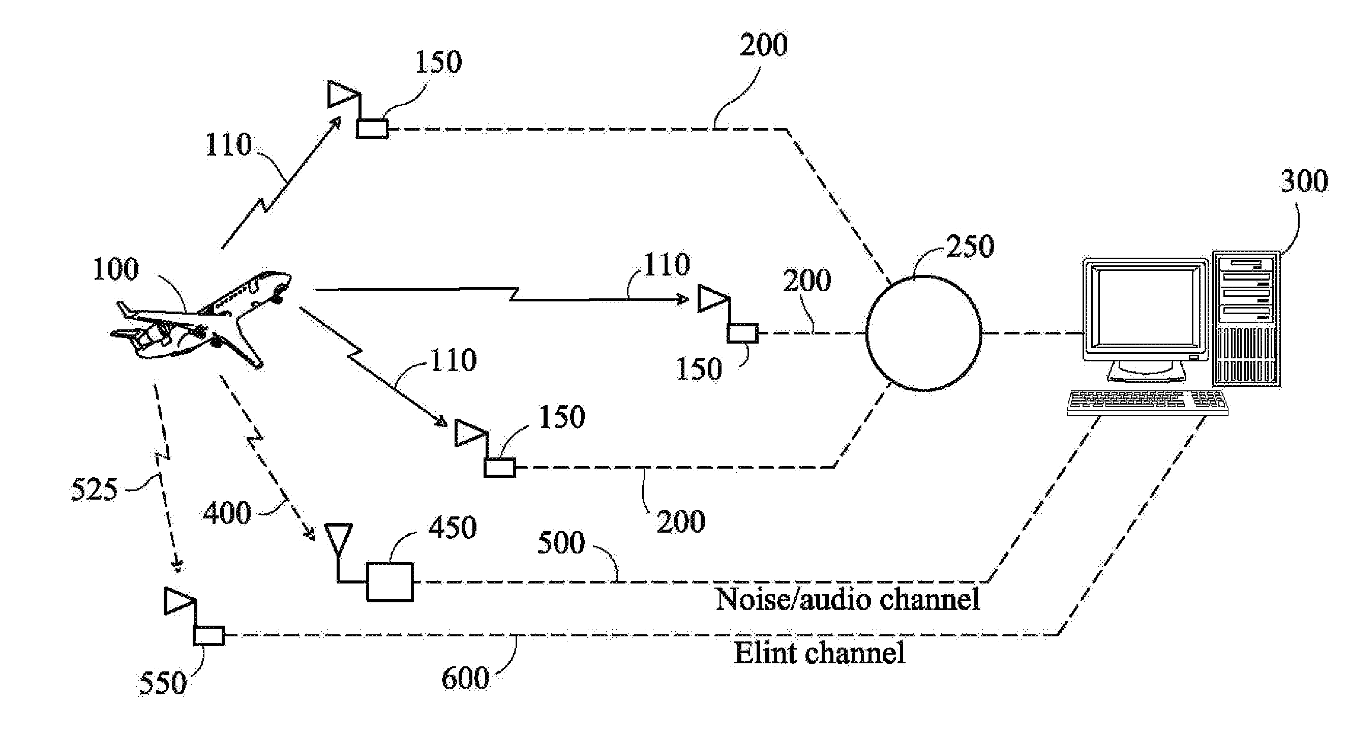
[0084]FIG. 12 is a block diagram illustrating the Coastal Defense and Homeland Security, Search and Rescue (Coastal and Mountainous Terrain) and ADS-B Back up and Validation of the present invention. In this embodiment there are essentially three channels of data from the aircraft 100 analyzed by the system in real time, one is flight tracking data based on multilateration of aircraft emitted signals 110 including transponder, DME, JTIDS, and various other pulse emitters located on the aircraft. The emitter signals are then time-stamped, either at the sensor 150 or at the central server 250 to perform TDOA analysis and pinpoint the location of the aircraft using multilateration techniques. Similarly, each sensor 150 may detect the aircraft's annunciated position as would be used by Automatic Dependent Surveillance Broadcast (ADS-B). The sensors 150 may be stationary and located on the ground, towers, or at sea on buoys, or they may be dynamic and located on marine vessels, aircraft,...


PUM


Abstract

This invention builds on previous industry techniques to correlate data from a variety of sources for the purposes of tracking and identifying aircraft, vehicles, and marine vessels in real time over a variety of different areas including oceans and mountainous terrain. Passive broadband tracking of aircraft emitters, and electronic fingerprinting of emitters, correlated with audio, video, infrared, primary radar and other information is employed to provide a comprehensive assessment of an aircraft's position, track and identification for a variety of applications including homeland security and search and rescue.

Description

CROSS-REFERENCE TO RELATED APPLICATIONS[0001]This application is a Continuation-In-Part of U.S. patent application Ser. No. 11 / 492,711, filed Jul. 25, 2006, and incorporated herein by reference; This application is a Continuation-In-Part of U.S. patent application Ser. No. 11 / 429,926, filed on May 8, 2006, and incorporated herein by reference; This application is a Continuation-In-Part of U.S. patent application Ser. No. 11 / 343,079, filed on Jan. 30, 2006, and incorporated herein by reference; This application is also a Continuation-In-Part of U.S. patent application Ser. No. 11 / 342,289 filed Jan. 28, 2006 and incorporated herein by reference; This application is a Continuation-In-Part of U.S. patent application Ser. No. 11 / 209,030, filed on Aug. 22, 2005, and incorporated herein by reference; This application is a Continuation-In-Part of U.S. patent application Ser. No. 11 / 257,416, filed on Oct. 24, 2005, and incorporated herein by reference; This application is a Continuation-In-P...

Claims


Application Information

Patent Timeline
Patent Type & Authority Applications(United States)
IPC IPC(8): G01S1/30
CPCG01S5/0081G01S1/30G01S5/22G01S5/06
Inventor SMITH, ALEXANDER E.
Owner ERA AS
Why Eureka
Try Eureka