Navigation signal transmitting apparatus, location information providing apparatus, method for transmitting navigation signal, and method for providing location information

a technology of location information and transmitting apparatus, which is applied in the direction of location information based services, navigation instruments, instruments, etc., can solve the problems of unstable reception state, degraded positioning accuracy, and inability to receive signals emitted from gps satellites, so as to improve positioning accuracy and reduce positioning time , the effect of reducing the time of positioning with a positioning signal from an indoor positioning transmitter

Active Publication Date: 2013-10-24
GNSS TECH INC
View PDF2 Cites 20 Cited by
  • Summary
  • Abstract
  • Description
  • Claims
  • Application Information

AI Technical Summary

Benefits of technology

[0046]In a certain embodiment, according to a navigation signal transmitting apparatus and a location information providing apparatus of the present invention, time of positioning with a positioning signal from an indoor positioning transmitter can be reduced in a receiver.
[0047]Further, in another embodiment, according to a navigation signal transmitting apparatus and a location information providing apparatus of the present invention, positioning accuracy can be improved and positioning time can be shorter in a receiver when handing over from indoor positioning to outdoor positioning.
[0048]The foregoing and other objects, features, aspects and advantages of the present invention will become more apparent from the following detailed description of the present invention when taken in conjunction with the accompanying drawings.

Problems solved by technology

It may often the case that the signal emitted from the GPS satellite cannot be received by a location information providing apparatus of the user, hindered by high buildings standing in large numbers.
Further, diffraction or reflection of the signal by a building may cause an error in the distance measurement using the signal and, as a result, positioning accuracy is often degraded.
Though a technique has been known to receive in a room a weak GPS signal that has passed through a wall or roof, state of reception is unstable and positioning accuracy is low.
According to the technique disclosed in Japanese Patent Laying-Open No. 2006-67086, however, the reader or writer is unique to the system for providing location information and lacks versatility.
In order to prevent interference, it is necessary to restrain transmission output, and therefore, the area in which location information is receivable is limited and it is difficult to obtain location information continuously.
Further, a very large number of transmitters are required to cover a wide area.
Wide-spread use of mobile phones, however, makes mobile communication more and more common and it becomes increasingly difficult to notify the location information of the caller, unlike in the case of a fixed telephone.
In a place where it is impossible to receive radio wave, such as in an underground mall or indoors, however, location information cannot be obtained by the conventional positioning technique.
Such an approach, however, requires that the transmitters are synchronized in time, increasing the cost of transmitters.

Method used


Image

  • Navigation signal transmitting apparatus, location information providing apparatus, method for transmitting navigation signal, and method for providing location information
  • Navigation signal transmitting apparatus, location information providing apparatus, method for transmitting navigation signal, and method for providing location information
  • Navigation signal transmitting apparatus, location information providing apparatus, method for transmitting navigation signal, and method for providing location information

Examples


first embodiment

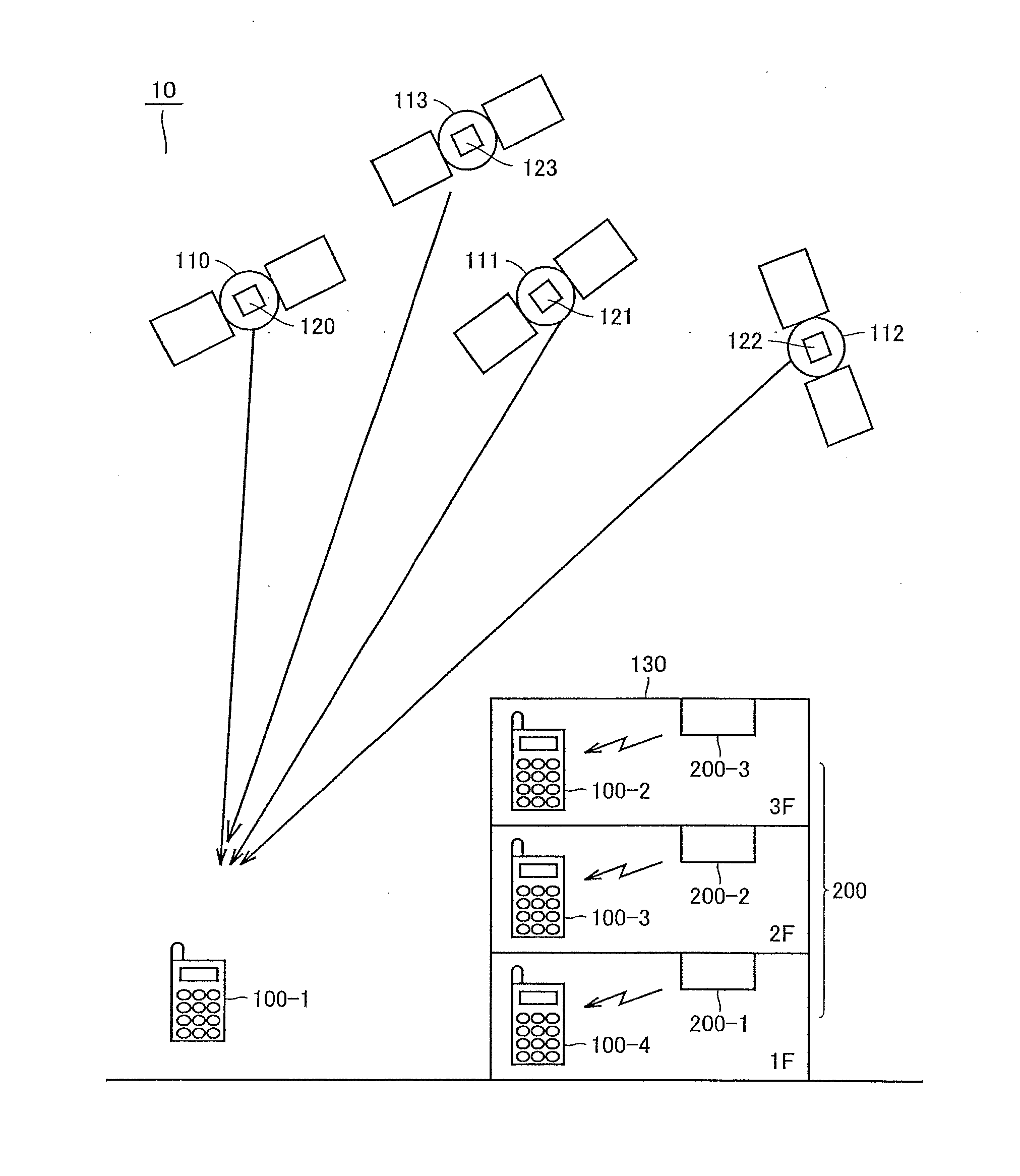
[0075]Referring to FIG. 1, a location information providing system 10 in accordance with a first embodiment of the present invention will be described. FIG. 1 shows a configuration of location information providing system 10. Location information providing system 10 includes: GPS satellites 110, 111, 112 and 113 flying at an altitude of about 20,000 km above the ground and emitting signals for positioning (hereinafter, referred to as “positioning signals”); and location information providing apparatuses 100-1 to 100-4 functioning as apparatuses for providing location information. Location information providing apparatuses 100-1 to 100-4 will be generally referred to as a “location information providing apparatus 100”. Location information providing apparatus 100 has a hardware configuration similar to that of a terminal having a conventional positioning apparatus such as a mobile phone, a car navigation system, or other mobile positioning apparatuses. However, location information p...

example 1

Gist of System of Example 1

[0243]As described above, the format of the signal transmitted from indoor transmitter 200 is not limited to one but various formats can be used.

[0244]However, in the description below, it is assumed that the transmitter ID, which is an identifier for identifying the location of indoor transmitter 200, is transmitted as a short ID (hereinafter, referred to as “SID”). However, the data format to transmit the identifier for identifying the location of indoor transmitter 200 is not limited to the SID. For example, a medium ID or the like can be used.

[0245]However, when the SID is used as the identifier, the SID is repeatedly transmitted in the shortest cycle among the formats of signal transmitted from the indoor transmitter. Hence, it is expected that the SID can be obtained in the shortest time by the receiver, i.e., location information providing apparatus 100.

[0246]The following describes gist of indoor positioning performed by indoor transmitter 200 and ...

example 2

[0306]Example 1 is concerned with the configuration in which the SVG map information is adapted to include the conversion table between the indoor transmitter's identifier transmitted from the indoor transmitter and the indoor transmitter's location information.

[0307]Example 2 is concerned with a configuration in which location information providing apparatus 100 also obtains orbit information of a positioning satellite to be used in outdoor positioning, when obtaining the SVG map information.

[0308]Specifically, for example, when location information providing apparatus 100 is started from a state in which it does not have orbit information (cold start), it is difficult to attain smooth positioning transfer because it requires a fair amount of time for obtainment of satellite data when handing over from indoors to outdoors. However, if the orbit information of the positioning satellite can be downloaded together with map information when obtaining the map information in indoors, pos...


PUM


Abstract

A navigation signal transmitting apparatus and a location information providing apparatus are provided for reducing time of positioning with a positioning signal from an indoor positioning transmitter. When an information providing server recognizes a transmitter ID of a transmitter from a mobile phone, the server makes reference refers to database associated with the transmitter ID, and reads SVG map information associated with the ID (including information for displaying a map and information of a correspondence relation between the transmitter ID and the location of the transmitter on the map). When the server transmits data of the SVG map information to a base station, the base station wirelessly emits the data of the SVG map information. When the mobile phone detects arrival of the data, the mobile phone can obtain the location of the transmitter from the data in accordance with a browsing operation of a user of the phone.

Description

TECHNICAL FIELD[0001]The present invention relates to a technique for providing location information, and relates to a navigation signal transmitting apparatus for transmitting a navigation signal and a location information providing apparatus. More particularly, the present invention relates to a technique for providing location information even in an environment out of reach of a signal transmitted from a satellite that emits a positioning signal.BACKGROUND ART[0002]GPS (Global Positioning System) has been known as a conventional positioning system. A satellite (hereinafter, referred to as “GPS satellite”) for emitting a signal used for the GPS (hereinafter, referred to as a “GPS signal”) flies at an altitude of about 20,000 km from the ground. By receiving and demodulating a signal emitted from the GPS satellite, a user can measure a distance between the GPS satellite and the user. Therefore, if there is no obstacle between the ground and the GPS satellite, positioning is possibl...

Claims


Application Information

Patent Timeline
Patent Type & Authority Applications(United States)
IPC IPC(8): H04B1/69H04W4/02H04W4/024
CPCH04B1/69G01C21/206G01S19/48G01S19/11H04W4/02H04W4/024
Inventor TORIMOTO, HIDEYUKIISHII, MAKOTOASAKO, MASAHIROOKANO, KAZUKIMATSUZAWA, YUZOTAKAHASHI, YOICHI
Owner GNSS TECH INC
Why Eureka
Try Eureka