Data fusion architecture

a data fusion and data technology, applied in the direction of steering initiation, instruments, transmission, etc., can solve the problems of loss of position beyond the acceptable limits, affecting the safety of personnel or equipment, or the environment, and the accuracy of the measurement data provided by a particular pme may not always be constant, so as to achieve the effect of reducing the accuracy of the measuremen

Active Publication Date: 2013-12-26
GE ENERGY POWER CONVERSION TECH
View PDF1 Cites 19 Cited by
  • Summary
  • Abstract
  • Description
  • Claims
  • Application Information

AI Technical Summary

Benefits of technology

[0028]The architecture requires that each sensor i provides accuracy data Hi indicative of the accuracy of the measurement data that it supplies, or that the accuracy of the measurement data provided by each sensor can be inferred from, or provided by, other means. Many sensors are capable of providing accuracy data directly. For example, the marine-standard NMEA (National Marine Electronics Association) message for GPS positions designated GGA includes data on the horizontal dilution of precision (HDOP) which is an indication of the effect of the prevailing satellite geometry on the accuracy of the fix. The NMEA standard LBP message for long baseline hydro-acoustic positioning systems includes data for error ellipse major axis, minor axis and orientation. Accuracy data can also be inferred from other means, including measurements provided by other sensors. For example, if the architecture forms part of a measuring system for measuring liquid levels within a tank onboard a marine vessel then the accuracy of the measurements will be reduced when the marine vessel is in rough seas and its motion causes the liquid to slosh about within the tank. In this case, an indication of the accuracy of the measurement data can be inferred from separate measurements of the attitude (pitch and roll) of the marine vessel. In other words, measurements of the attitude of the marine vessel provided by other sensors can be used as the accuracy data for the measuring system, optionally after pre-processing or filtering has been applied.
[0029]The fast-acting accuracy data enables the architecture to derive second estimates that take into account any sudden changes in the accuracy or quality of the measurement data being supplied by each sensor. However, it will be readily appreciated that the architecture also takes account of longer term changes in accuracy by using the measurement data to derive the first estimates as described above.

Problems solved by technology

In many applications a loss of position beyond the acceptable limits may have a severe impact either on the safety of personnel or equipment, or on the environment.
The main difference is the level of noise on the measurement data.
The accuracy of the measurement data provided by a particular PME may not always be constant.
Because it relies on previous position measurements, the accuracy estimate is slow to respond to sudden changes in the behaviour of the PME, e.g. when the receiver of a DPGS system loses sight of a number of satellites due to shading.

Method used


Image

  • Data fusion architecture
  • Data fusion architecture
  • Data fusion architecture

Examples


Embodiment Construction

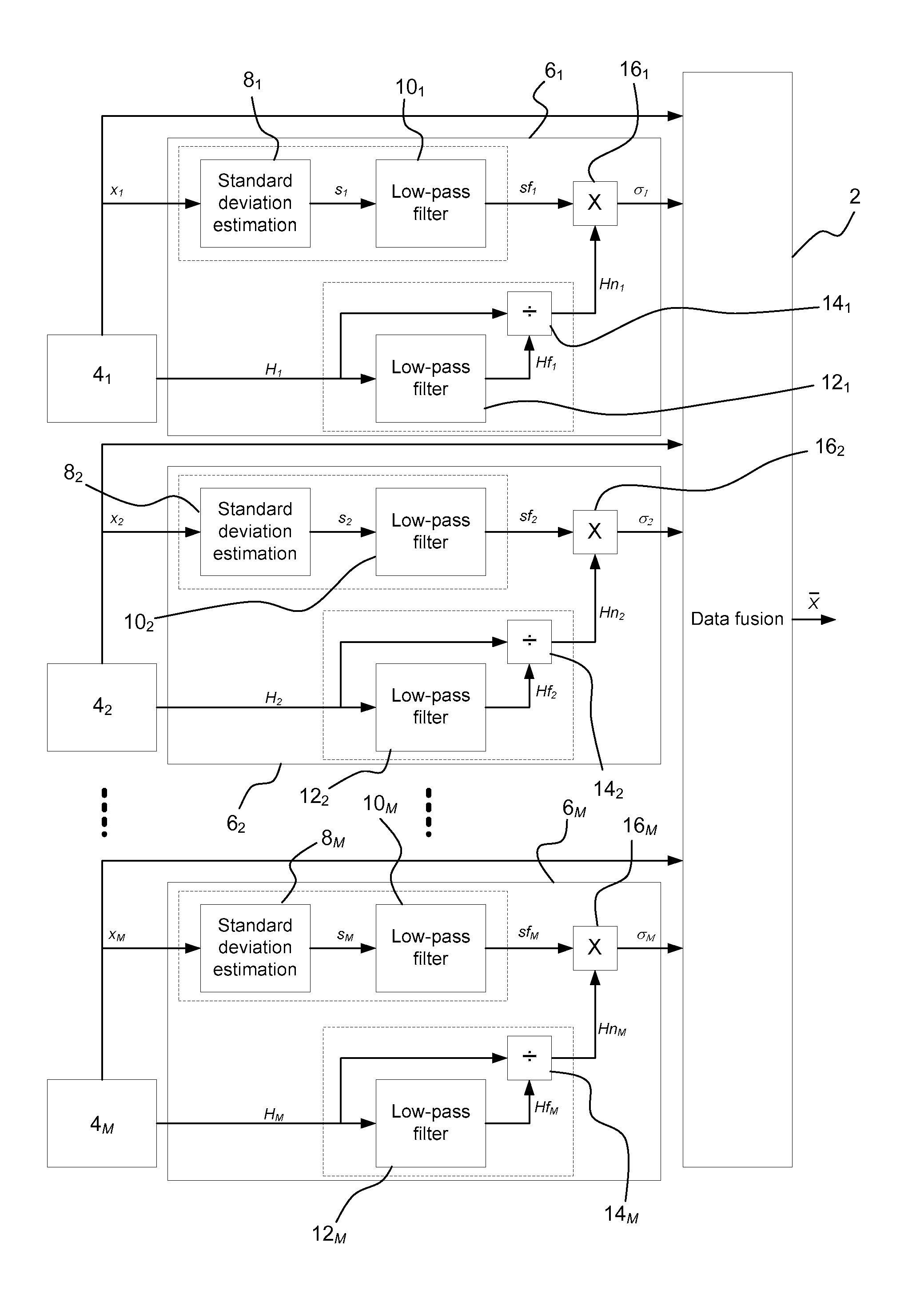
[0047]An improved architecture for a dynamic positioning (DP) system for a marine vessel will now be explained with reference to FIG. 1.

[0048]A DP system includes a Kalman filter 2 (labelled ‘Data fusion’) to combine position measurements to derive an estimate of the position and heading of the marine vessel. The output X of the Kalman filter 2 is supplied to a vessel control unit (not shown) that outputs a signal to thrusters to cause them to bring the position of the vessel closer to a desired reference position.

[0049]The position measurements are supplied by a plurality of sensors 41, 42 . . . 4M (where M≧2) or position measuring equipment (PME) located on the marine vessel. The sensors 41, 42 . . . 4M can be of the same or of different types including inter alia hydro-acoustic positioning systems providing long baseline (LBL) position measurements and / or ultra-short baseline (USBL) position measurements, satellite navigation systems providing GPS or differential GPS (DGPS) posit...


PUM


Abstract

A data fusion architecture with a plurality of sensors, optionally position measuring equipment (PMEs), is described. Each sensor supplies measurement data x1, x2 . . . xM and is associated with accuracy data H1, H2 . . . HM indicative of the accuracy of the supplied measurement data. Sub-processing units derives first estimates sf1, sf2 . . . sfM and second estimates Hn1, Hn2 . . . HnM of the variability of the measurement data supplied by the respective sensor. The first estimates are derived by processing the measurement data x1, x2 . . . xM and the second estimates are derived by processing the accuracy data H1, H2 . . . HM. The first and second estimates are combined in a multiplier to derive overall estimates σ1, σ2 . . . σM of the variability of the measurement data supplied by the respective sensor. Data fusion means such as a Kalman filter combines the measurement data supplied by each sensor and the overall estimates σ1, σ2 . . . σM for each sensor.

Description

FIELD OF THE INVENTION[0001]The invention relates to an architecture for data fusion, i.e. the combining of data or measurements from two or more sources. The architecture can be used as part of any system which requires the combination of data from a plurality of sensors, including a dynamic positioning (DP) system for marine vessels where thrusters are used to maintain the position of a vessel in the vicinity of a reference point and stabilise its heading, in opposition to environmental forces such as wind and current.[0002]The term “marine vessels” is intended to include ships, drilling rigs and any other surface-going vessels or platforms or submersible (submarine) vessels.BACKGROUND OF THE INVENTION[0003]The fundamental components of a dynamic positioning (DP) system are: one or more position reference systems to measure the vessel position and heading; thrusters to apply control action; and a controller to determine the required thrusts. The object of a DP system is not to hol...

Claims


Application Information

Patent Timeline
Patent Type & Authority Applications(United States)
IPC IPC(8): G01B21/16
CPCG01B21/16G01C21/20G01C21/28B63H25/04
Inventor STEPHENS, RICHARD IAN
Owner GE ENERGY POWER CONVERSION TECH
Why Eureka
Try Eureka