
System, method and computer program for dynamic generation of a radio map

a radio map and computer program technology, applied in the field of dynamic radio map generation, can solve the problems of difficult to provide a satisfactory level of accuracy for most locating applications, hardware installation or modification, unpredictable radio propagation channel, etc., and achieve satisfactory level of localization accuracy, reduce labor cost of fingerprint collection significantly, and evaluate performance

Active Publication Date: 2014-01-09
THE GOVERNINIG COUNCIL OF THE UNIV OF TORANTO
View PDF9 Cites 134 Cited by
  • Summary
  • Abstract
  • Description
  • Claims
  • Application Information

AI Technical Summary

Benefits of technology

The patent describes an approach to learning a radio map for a mobile device using a small number of fingerprint samples. This approach uses compressive sensing to build a graph structure and calculate the weight of each node in the map. By learning this map, the device can be located and provided with location-based services. The method reduces the cost of collecting fingerprints and maintains a satisfactory level of localization accuracy. The patent also discusses an indoor learning and positioning system that can evaluate the performance of the proposed approach. The technical effects of this patent are to provide a cost-effective and efficient way to learn a radio map for mobile devices, which can provide improved location-based services.

Problems solved by technology

However, due to the relative complexity of indoor environments, it is usually difficult to provide a satisfactory level of accuracy for most locating applications.
One of the key challenges that arise is how to design an accurate, real-time indoor positioning system that can be easily deployed on commercially available mobile devices without costly hardware installation or modifications.
However, in an indoor environment, the radio propagation channel may be unpredictable and time-varying, due to severe multipath, shadowing effects arising from reflection, refraction and scattering from obstacles and walls, and interference with other devices operated at the same frequency.
Hence, the direct translation from RSS to distance for positioning limits the algorithm applied in complicated indoor environment such as shopping mall, hospital, etc.
This method may only give a very rough position estimate, resulting large location ambiguity.
However, pre-collecting fingerprints, known as an RSS radio map, a complete table of RSS readings at defined grid points on the map, is time consuming and involves an extensive labor cost, which largely limits service site.
Obtaining accurate RSS-based positioning may be a challenge because of inherent variations in RSS which may result from the dynamic and unpredictable nature of radio transmissions due to shadowing, multipath, interference, the orientation of wireless device, etc.
Alternative means of determining the location of a device, such as global positioning systems (GPS), may not provide an optimal foundation for indoor LBSs because of potential signal outages resulting from building structures, positional inaccuracies, and other technical problems due to signal interference which prevents effective location determination and tracking.
However, many users may be concerned about the privacy implications of their movements being traced by a remote computer via their mobile devices.
Furthermore, some privacy breaches caused by dealings between individuals and web companies have become highly publicized and have heightened concern around possible privacy implications of location based services in particular.

Method used


Image

  • System, method and computer program for dynamic generation of a radio map
  • System, method and computer program for dynamic generation of a radio map
  • System, method and computer program for dynamic generation of a radio map

Examples


example # 1

Example #1

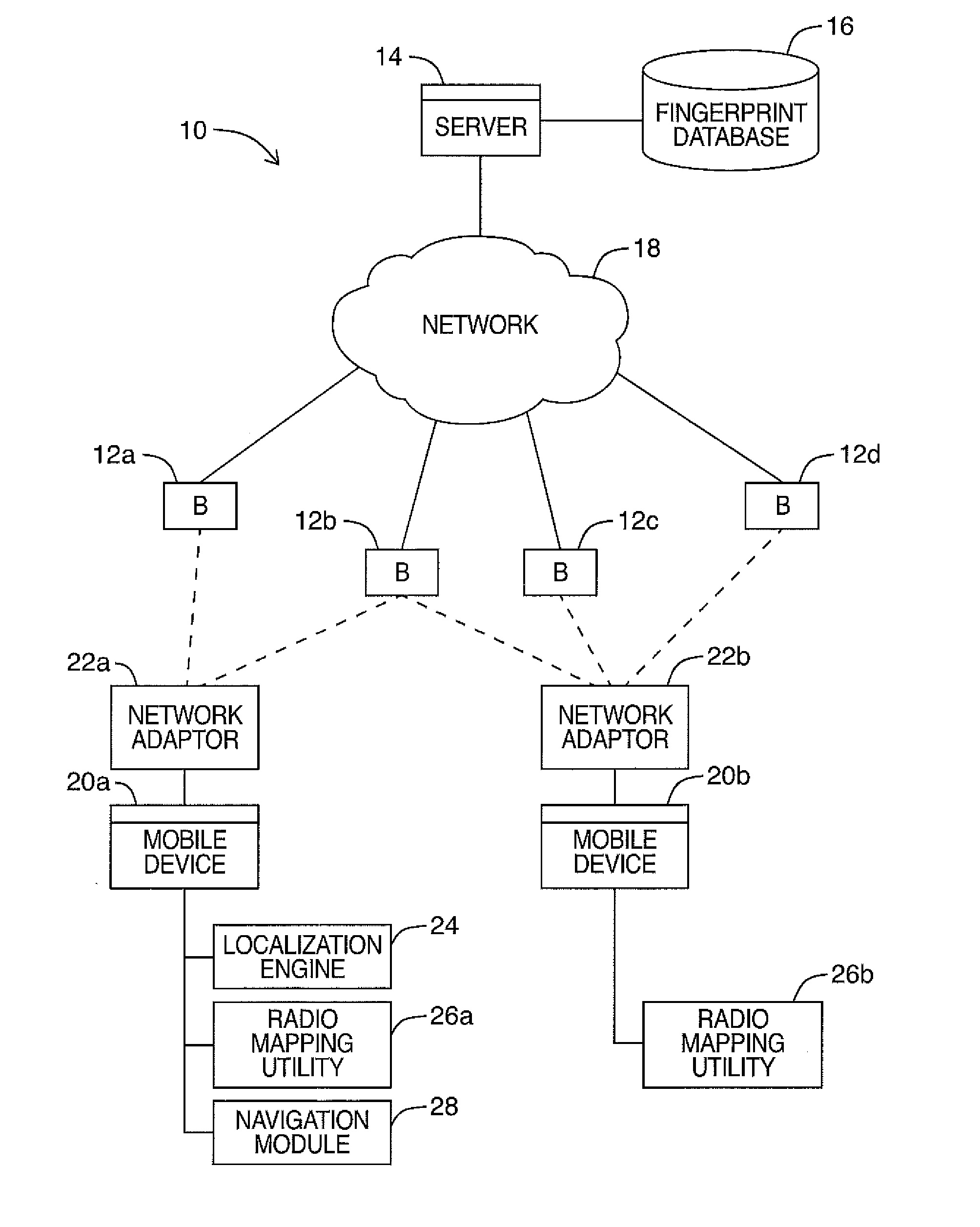
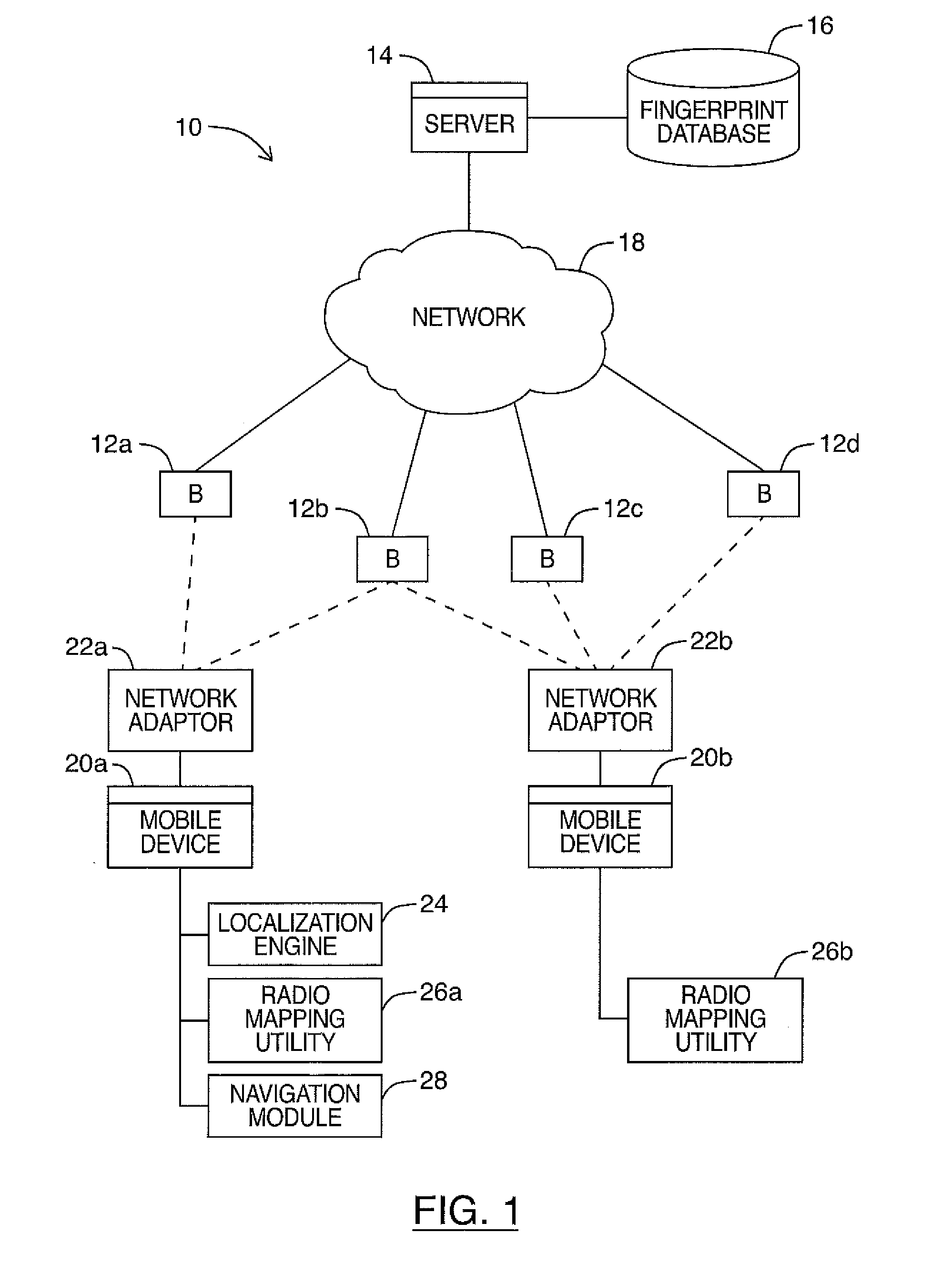
[0195]Real data were obtained from an office building. Specifically, the experiments were carried out on a 30 m×46 m area of the fourth floor of an eight-story building (Bahen Center at the University of Toronto). A total of 26 beacons 12 were detected throughout the area of interest.

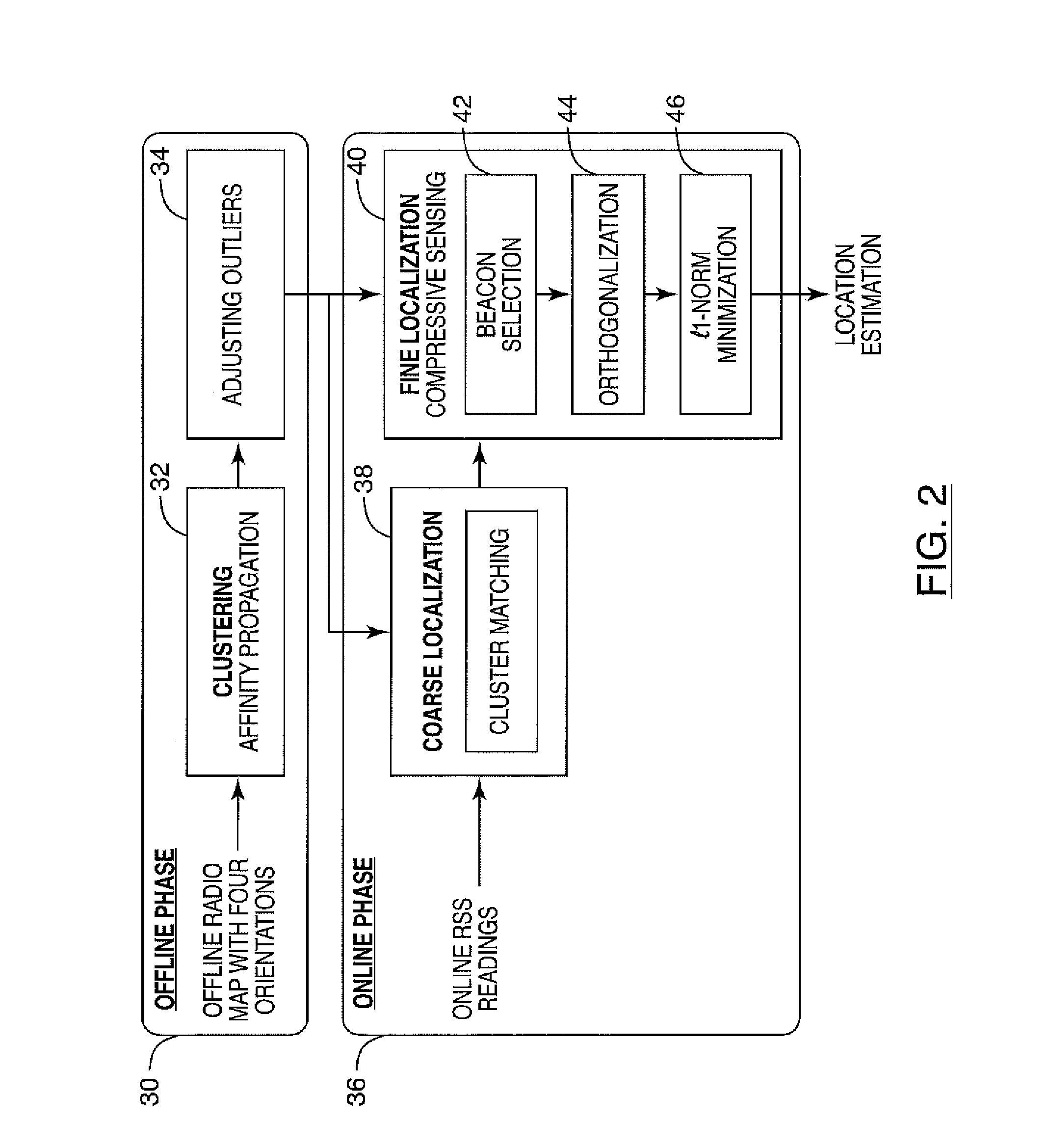
[0196]A personal digital assistant (PDA) or mobile device (HP iPAQ hx4700 with Windows Mobile 2003 pocket PC) was used to measure WLAN signal strength value, and a software was developed in Visual Studio C# to implement the CS-based positioning system on the device. The RSS values were collected on the device by using the open source library OpenNetCF, which provides access to MAC address and RSS values of WLAN APs. During the offline phase, the RSS observations from 26 beacons 12 were recorded for a period of 50 seconds (one sample per second) over 72 reference points with an average grid spacing of 1.5 m. At each reference point, RSS values from four orientations were recorded. The online ob...

example # 2

Example #2

[0207]A software application (e.g. indoor location resources) was developed on mobile devices 20 installed with Windows Mobile platform to implement the proposed indoor tracking and navigation system. The software was developed in C# using Microsoft .Net Compact Framework version 3.5. In addition, two open source libraries: OpenNetCF and DotNetMatrix were used to provide the RSS scanning function and matrix operations to the program. The software was tested on a mobile device 20 (e.g. PDA) manufactured by HP, hp iPAQ hx2750. The overview of the software and configured hardware is illustrated in FIG. 12.

[0208]The location determination system with prediction was tested at the second floor of the Canadian National Institute for the Blind (CNIB) with area dimensions of 18 m×36 m. During the offline phase, the developed software was run on the PDA to collect 100 RSS time samples for each of four orientations: North, East, South and West (with the sampling rate of 1 sample per ...

example # 3

Example #3

[0217]The embodiments described herein for generating a radio map dynamically may be implemented as a computer system that implements the disclosed techniques.

[0218]The embodiments described herein may be further applied in a number of practical systems that utilize the radio map prediction mechanism provided in this disclosure.

[0219]For example, a system and method may be constructed using the radio map prediction mechanism of the embodiments described herein that is configured to quickly monitor a person's location in an indoor environment to provide better security and protection services. Such a system may be used for example to monitor the location of a child in a kindergarten, a patient in a hospital, an elderly in an open indoor area, etc.

[0220]In another possible application of the system and method disclosed, a computer system may be configured to dynamically generate a radio map covering an indoor or outdoor area associated with one or more smart TVs. The compute...


PUM


Abstract

Embodiments described herein provide a system, method and computer program for dynamic radio map generation, which may be used for indoor positioning of one or more mobile devices based on received signal strength (RSS) in some examples. In an aspect, a dynamic scheme may be used to learn the RSS radio map from only a small number of fingerprint samples. Compressive sensing may be applied to build the graph structure and calculate the graph weight in some embodiments. Once the RSS radio map is learned, a mobile device may be located and location based services can be provided to the user in some example embodiments. An indoor learning and positioning system on a mobile device may be used to evaluate the performance. Embodiments described herein may not require a large amount of offline calibrations, which may reduce the labor cost of collecting fingerprints significantly while maintaining a satisfactory level of localization accuracy.

Description

PRIORITY CLAIM[0001]This application claims the priority of U.S. Provisional Application 61 / 664,459 filed Jun. 26, 2012, the entire contents of which is hereby incorporated by reference.FIELD[0002]Embodiments described herein relate generally to determining a dynamic radio map. More particularly, embodiments described herein relate to a system, method and computer program for dynamic generation of a radio map based on sets of data elements, such as received signal strength (RSS) readings, for example. As an illustrative and non-limiting example, the dynamic radio map may be used for indoor positioning of one or more mobile devices. In some example embodiments, the system, method, and computer program may further involve determining the indoor positioning of a network of connected wireless mobile devices using the dynamic radio map.INTRODUCTION[0003]Recent advances in smart phones have made it feasible to provide indoor Location-Based Services (LBSs) utilizing low cost Wireless Local...

Claims


Application Information

Patent Timeline
IPC IPC(8): H04W4/02H04W4/33
CPCH04W4/025H04W64/00G01S5/02526G01S5/02524H04W4/33H04B17/318
Inventor VALAEE, SHAHROKHFENG, CHEN
Owner THE GOVERNINIG COUNCIL OF THE UNIV OF TORANTO
Learn More