Method of rendering a terrain stored in a massive database

a database and database technology, applied in the field of rendering a terrain stored in a massive database, can solve the problems of inability to work on massive databases with conventional database management and access tools, high computation costs, and complex utilization of massive databases, and achieve the highest possible level of detail

Inactive Publication Date: 2014-06-05
THALES SA
View PDF4 Cites 18 Cited by
  • Summary
  • Abstract
  • Description
  • Claims
  • Application Information

AI Technical Summary

Benefits of technology

[0039]The invention has notably the main advantages of rendering a scene comprising a very extensive terrain, stored on complex visual databases with the richest possible level of detail as a function of the application of the rendering of images. Notably, the content of the image in a radius close to the observer is enriched, so as to be able to distinguish details on the elements close to the observer.

Problems solved by technology

One of the problems related to the rendering of terrain in an outside setting is that the outside environment is described by means of terrain data of significant size.
The utilization of massive databases is very complex and expensive in computation time and in cache memory in respect of the processors for handling these data.
Notably it is impossible to work on massive databases with conventional database management and access tools.
With respect to the original texture, the use of mipmaps introduces a memory cost overhead of the order of thirty percent.
However, recourse to these specific techniques complicates both the production of data and the development of the rendering software.
In particular, these techniques induce restrictions on the geometric representation of the data, which render them inapplicable to the urbanized zones of the terrain, comprising notably buildings.
Moreover it is then necessary to manage the continuity between the non-urbanized zones and the other zones, thereby further complicating the software.
Thus, the current solutions based on levels of terrain detail do not make it possible to manage elements such as buildings or even simple parapet walls.
This poses the following problems: the production of the terrain data and the development of the software utilizing these terrain data is particularly complex.
Also, a problem of continuity arises systematically at the boundary between the relief terrain zones managed by these techniques and the zones managed by other techniques, which in general, are discrete levels-of-details techniques.
Moreover, these techniques usually rely on a representation of the terrain in the form of regular grids, which are rather inefficient in terms of data compactness.
A drawback of geo-morphing is that it requires dynamic management of the intermediate representations.
Here again, in addition to a negative impact on the performance of the rendering computation by the graphics card, the impact on the complexity of the development of the rendering software can pose a problem.
Though the problems related to bandwidth are mentioned in the works on clipmapping, they do not propose any concrete strategy for predicting and distributing the updates efficiently over time, for example as a function of the displacement of the centre of interest.
Another problem with current techniques is related to the strategy chosen for refreshing the rendered image, and notably to the technique for transition between the levels of detail.
The current solutions therefore deal each time with only one of the aspects of the general problem of displaying massive terrain data in real time, with a significant risk of disturbance of the image.
This considerably impairs the realism of the scenes representing the evolving training setting.

Method used


Image

  • Method of rendering a terrain stored in a massive database
  • Method of rendering a terrain stored in a massive database
  • Method of rendering a terrain stored in a massive database

Examples


Embodiment Construction

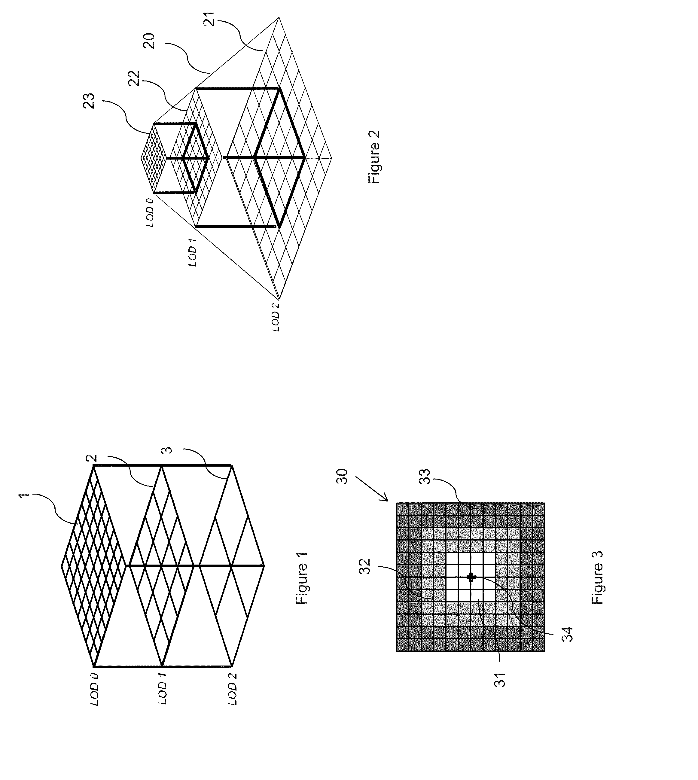
[0054]FIG. 1 represents an exemplary subdivision of a database into patches for several levels of details LOD0, LOD1, LOD2. LOD is an acronym for the expression Level Of Details.

[0055]The method according to the invention takes as input a description of terrain data stored in a massive database. The terrain data can notably be described in the database by means of one or more irregular meshes. These meshes can for example describe the relief of the terrain, as well as elements present on the terrain such as trees, buildings, highway maintenance elements, etc. A first step of the method according to the invention is a step of paving the database into tiles for several levels of different resolution. For example the paving can be analogous to the pavings used in clipmapping. The paving of the database can produce for example a first decomposition grid 1 of a terrain, for a first level of detail LOD0. The first grid 1 can be a square grid comprising eight rows and eight columns such as...


PUM


Abstract

A method of rendering a terrain stored in a massive database the said terrain rendering being displayed for an observer by a display device comprising at least one graphics card comprising a cache memory, comprises at least: a step of generating several regular grids of different resolution level terrain patches so as to represent the terrain data of the massive database; a step of extracting terrain data from the massive database for several resolution levels, the extracted terrain data forming an extraction pyramid, composed of an extraction window for each level of detail, placed in cache memory. Each window comprises an active zone intended to be displayed, and a preloading zone which makes it possible to anticipate the transfers of data; a step of selecting the patches of the extraction pyramid which contribute to the image; and a step of plotting the rendering on the basis of the selected patches.

Description

CROSS-REFERENCE TO RELATED APPLICATION[0001]This application claims priority to foreign French patent application No. FR 1203242, filed on Nov. 30, 2012, the disclosure of which is incorporated by reference in its entirety.FIELD OF THE INVENTION[0002]The present invention relates to a method of rendering a terrain stored in a massive database. The invention is notably applicable to the generation of synthesis images by simulation software within the framework of training a pilot to pilot a craft.BACKGROUND[0003]The generation of synthesis images representing an outside setting can apply to numerous contexts: for example, for the training of pilots of craft using a simulator of the craft and of its environment evolving in real time. The training can apply to helicopter pilots, and also to drivers of terrestrial craft. The generation of synthesis images can also apply to computer games so as to simulate an outside environment. Most simulation systems using the generation of synthesis ...

Claims


Application Information

Patent Timeline
Patent Type & Authority Applications(United States)
IPC IPC(8): G06T3/40
CPCG06T3/40G06T17/05
Inventor LE MEUR, GILDAS
Owner THALES SA
Why Eureka
Try Eureka