
Geographic layout of petroleum drilling data and methods for processing data

a technology for petroleum drilling and data, applied in data processing applications, instruments, computing, etc., can solve the problems of limited petroleum industry application of these maps, difficulty in collecting proper data on production and collection of various crude oil and natural gas volumes, and loss of particular clients in all the data

Inactive Publication Date: 2014-06-05
DRILLMAP
View PDF3 Cites 297 Cited by
  • Summary
  • Abstract
  • Description
  • Claims
  • Application Information

AI Technical Summary

Benefits of technology

This patent describes a system and method for collecting and displaying petroleum activity data in a customizable way. The system can geospatially model the data and filter it based on user needs. The data can be displayed over a network system using a web-based interface. The system allows users to access and update the information continuously. Overall, this invention provides a more efficient and flexible way to collect and display petroleum activity data.

Problems solved by technology

Collecting proper data on production and collection of various crude oil and natural gas volumes is often a difficult task; the data is often not organized in a manner that allows users to view various data efficiently.
The data may be organized by region (e.g., country, state, county, etc.), type of activity (e.g., drilling for oil or gas, geothermal, etc.), location (e.g., land or offshore), or well type (e.g. development, exploration, or infill), but to view the overall collection process or to appreciate how the data may impact a particular client is often lost in all the data.
The proliferation of web-based systems allow for the geographic display of maps, such as Google Maps, Bing Maps, Yahoo Map, and Mapquest.com, but the application of these maps are limited in the petroleum industry.
Both the oil and gas industries require recordation of a vast amount of data which is difficult to geographically represent and document.
The current state of the prior art shows no ability to create user-specific filters to organize the vast amount of information and to visually display user-specific activity of petroleum collection data, and such.
There are currently many disadvantages to traditional methods of collecting and analyzing petroleum data.
For one thing, it is extremely time-consuming for a client to scour all the various public information to obtain the necessary information that they need.
Furthermore, it is often difficult to visualize any of the production levels or petroleum data by viewing tables of data that are offered by the numerous websites.
The system disclosed by Arango et al. falls short of being able to provide a full picture of petroleum data.
The publicly available petroleum data is vast, which includes a large number of fields outside rig data.
Furthermore, Arango et al fails to provide a versatile user specific capability to generate customizable reports and geospatial maps in accordance with those customer preferences.
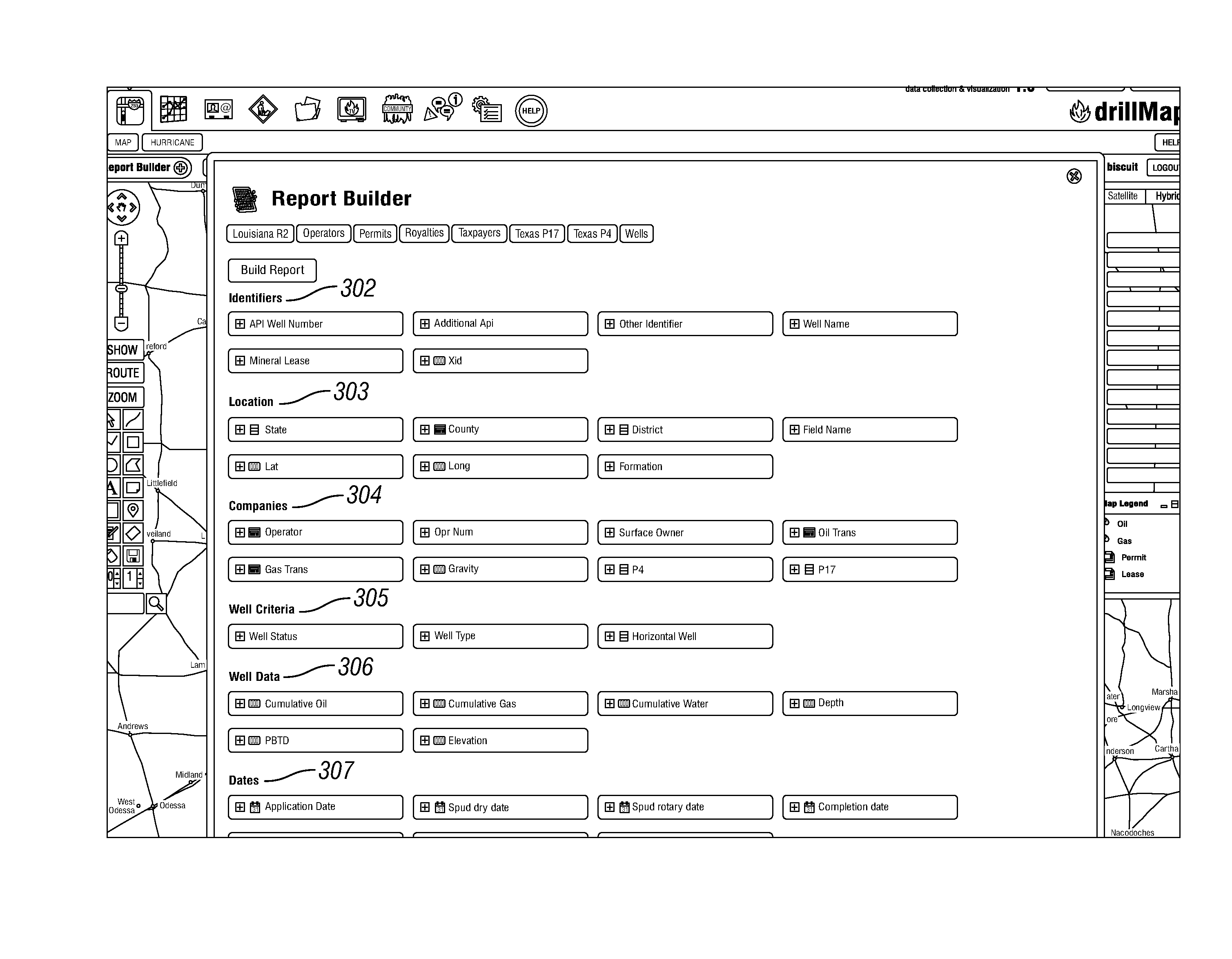
There is currently no system that allows for the versatile customization of individual reports and the ability to visualize petroleum data, such as petroleum based bids, contact information for the various operators, petroleum quality, petroleum tax or tariff information, production, collection, leasing, permits, and pipeline layout information for each of the clients.

Method used


Image

  • Geographic layout of petroleum drilling data and methods for processing data
  • Geographic layout of petroleum drilling data and methods for processing data
  • Geographic layout of petroleum drilling data and methods for processing data

Examples


Embodiment Construction

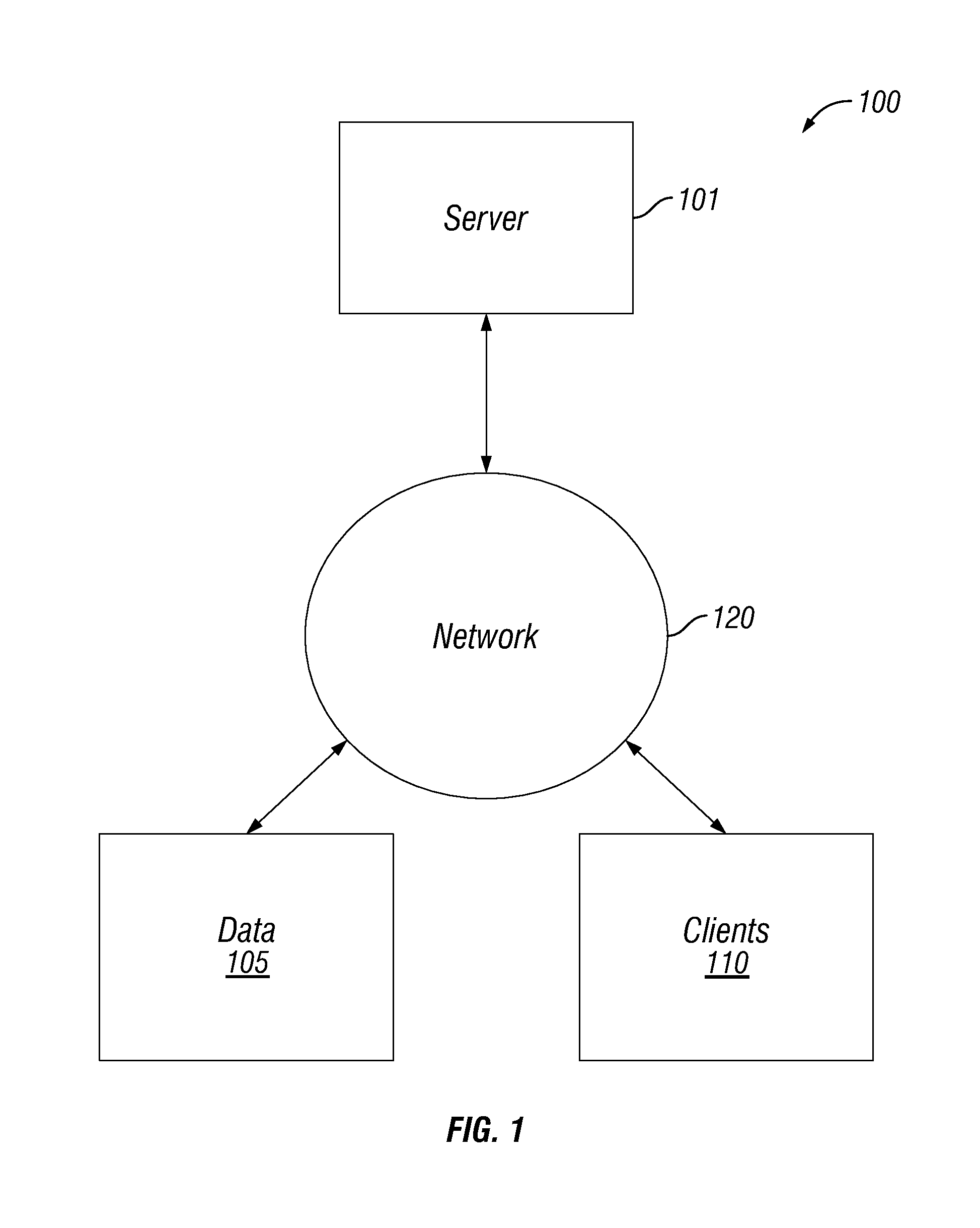
[0023]FIG. 1 is a general schematic block diagram in accordance with the embodiments of the present invention. The system 100 includes one or more clients 110 that are in communication with server 101 via one or more networks 120. Although multiple clients 110 and a single server 101 are illustrated in FIG. 1, there can be more servers and more or fewer clients. For instance, some of the functions performed by the server 101 can be performed by one or more other servers such that the server 101 can represent several devices, such as a network of computer processors and / or servers. Additionally, in some implementations, the server 101 can perform a function of a client. The client 110 is representative of an end user that can implement many different types of devices, such as a personal computer, a wireless telephone, a personal digital assistant, a smart phone, a lap top computer, a tablet, or another type of computation or communication device, a thread or process running on one th...


PUM


Abstract

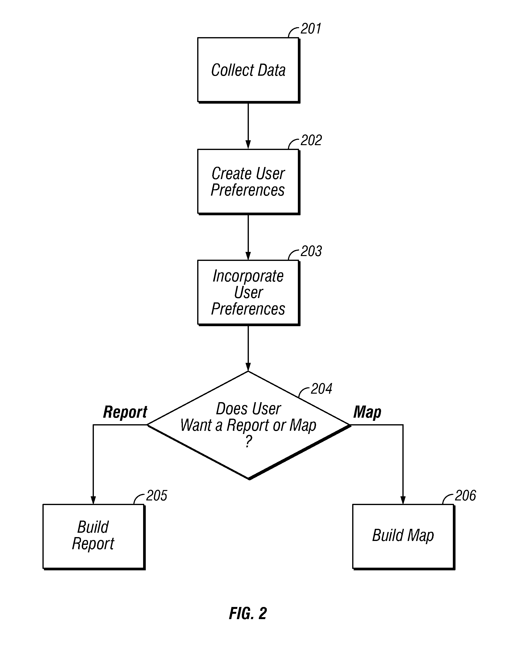
The embodiments of the present invention provide systems and methods which update petroleum activity data and allows for geospatial modeling of the data in an interactive fashion or for the creation of a report to display customizable reports in accordance with user-preferred fields. Embodiments of the present invention also provide methods for collection of data from various Internet resources, including Federal Energy Regulatory Commission, and specifically allow user-friendly interaction to select various fields, such as bids, contract information, well production, and produce graphical representation or generate reports that accounts for the organization of the data.

Description

[0001]This application claims priority from U.S. Provisional Patent Application Nos. 61 / 731,787, filed Nov. 30, 2012, and 61 / 737,317, filed Dec. 14, 2012, both titled “Geographic Layout of Petroleum Drilling Data and Methods for Processing Data” which are hereby incorporated by reference.TECHNICAL FIELD OF THE INVENTION[0002]The present invention relates to methods and processes of generating user-friendly geographic layouts and reports that collects petroleum drilling and production data, filters the data, provides user-specific analysis of the data, and displays and summarizes the data in a report or geospatial map through a web-based service, or the like.BACKGROUND OF THE INVENTION[0003]Information relating to petroleum supply, processing of petroleum, production of petroleum, permits, licenses, and petroleum collection is offered on various governmental websites and independent sources. Drilling data of crude oil or natural gas drilling activity can be found on websites offered ...

Claims


Application Information

Patent Timeline
IPC IPC(8): G06F3/0484G06F3/0481
CPCG06F3/04817G06F3/0484G06Q50/02G06Q10/10
Inventor PEERY, AARON ROSSRICHARDS, ROBERT
Owner DRILLMAP
Learn More