Positioning apparatus and global navigation satellite system, method of detecting satellite signals

a positioning apparatus and satellite technology, applied in the field of vehicle positioning apparatus, can solve the problems of inability of gnss receiver to provide in real time information of correct positions, electromagnetic signals supplied by satellites can only be partially received, and the position defined by gnss receiver is not corr

Active Publication Date: 2016-02-11
STMICROELECTRONICS INT NV
View PDF19 Cites 36 Cited by
  • Summary
  • Abstract
  • Description
  • Claims
  • Application Information

AI Technical Summary

Problems solved by technology

In many real cases, for example in an urban environment, possible noises, radio frequency (RF) interferences, reflections of signals, errors in the transmission or spurious transmissions of signals prevent or degrade the integrity of the signals received from the satellites and / or the continuity of the received data, and therefore the positions defined by the GNSS receiver are not correct.
In the standard navigation applications, the calculated latitude and longitude are matched on a one-level (two-dimensional) map and, in the presence of the above mentioned errors, this is difficult.
Moreover, in indoor environments such as parking lots, underground garages, tunnels and similar, the electromagnetic signals supplied by the satellites can completely disappear or are only partially received, and the GNSS receiver is not capable of providing in real time information of correct positions.
Despite the fact that the inertial sensors are adequate under several aspects, they are not very reliable in the long term.
Even though the inertial sensors are reliable in the short term and insensitive to environmental problems typically troubling the electromagnetic signals, they are prone to errors (caused by the measuring noise and calibration errors) building up with time.
Therefore, their performances deteriorate in the long term and the supplied information, such as the position, in other words the longitude and latitude, the altitude, and the speed or heading of the vehicle, are not reliable.
Further, it is well to observe that a navigation device with signals received from a satellites constellation is reliable in the long term, however the obtained data can be incorrect in the short term, for example due to an incorrect or absent reception of signals.

Method used


Image

  • Positioning apparatus and global navigation satellite system, method of detecting satellite signals
  • Positioning apparatus and global navigation satellite system, method of detecting satellite signals
  • Positioning apparatus and global navigation satellite system, method of detecting satellite signals

Examples


Embodiment Construction

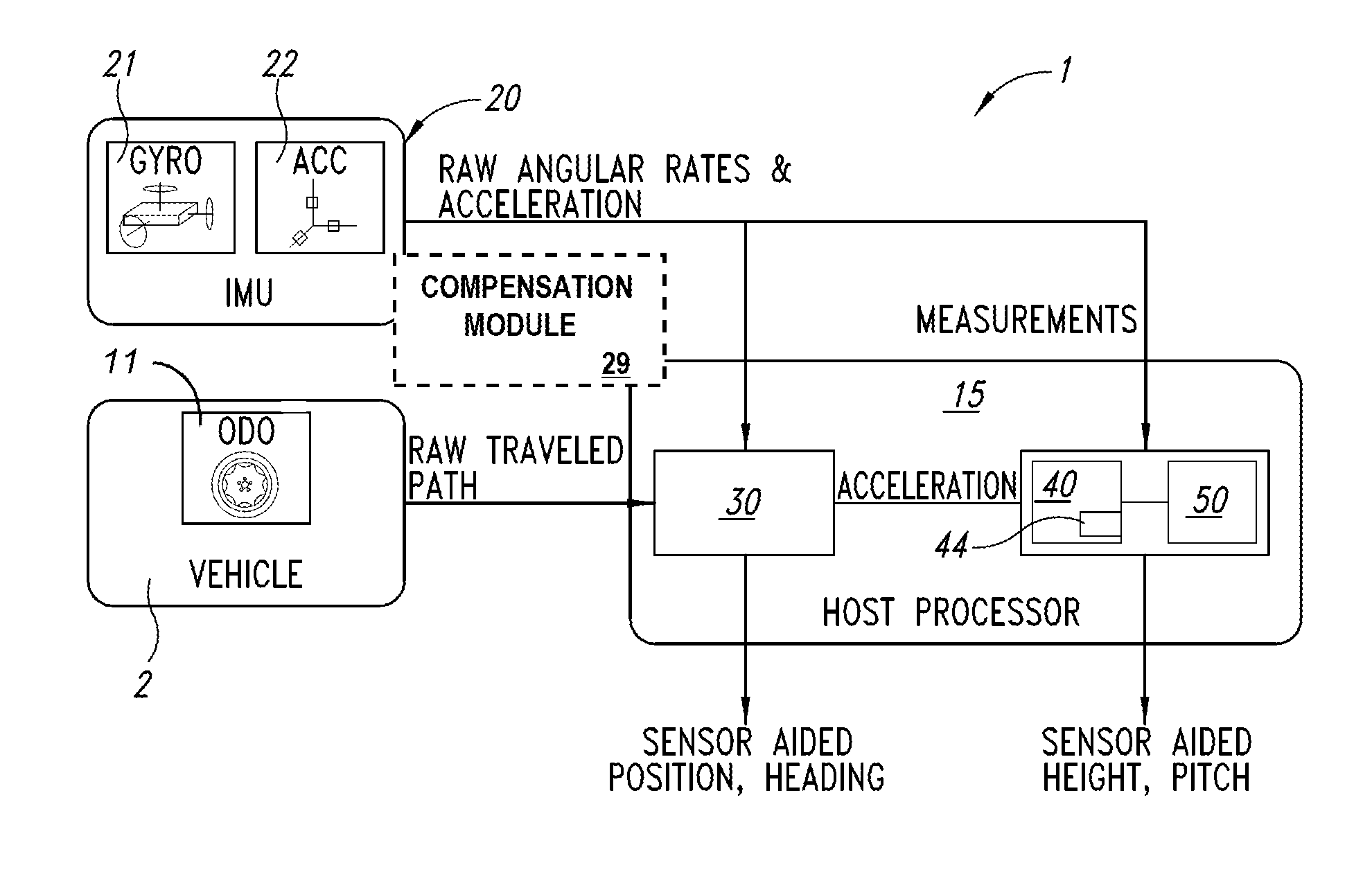
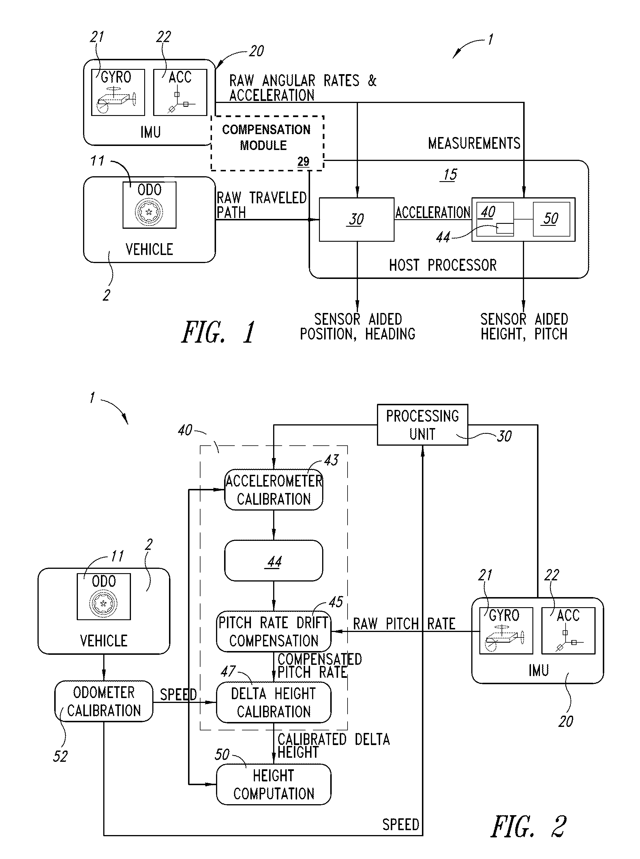
[0036]FIG. 1 schematically shows a positioning apparatus 1 according to a first embodiment, which can be installed on a vehicle 2. The positioning apparatus 1 enables acquisition of a current position of the vehicle 2 at a current time t, in other words the latitude, longitude and altitude, and to calculate the difference in level with respect to an absolute position relative to a previous time tt-1.

[0037]The positioning apparatus 1 enables calculation of the 3-D position, in other words a three-dimensional position: latitude, longitude and altitude of the vehicle 2, by using a system configured for detecting a current 2-D position and for obtaining the altitude of the vehicle at current time t from a previous altitude calculated at time tt-1.

[0038]The used system is of the Dead Reckoning type provided with inertial sensors. In the present embodiment, it is also used a non-inertial sensor such as an odometer sensor that in the following description will be simply indicated as odomet...


PUM


Abstract

A positioning apparatus of a vehicle includes a measuring module and a triaxial orientation sensor to provide measured axial accelerations in a Cartesian reference system during a certain time interval. The apparatus also includes a triaxial movement sensor to supply at least one angular variation signal proportional to the axial angular speed of the vehicle during the time interval. A processing unit receives a distance signal proportional to the distance traveled by the vehicle in the time interval, receives the at least one angular variation signal, and supplies at least one reference acceleration of the vehicle. An estimator-calibrator block recursively estimates at least one calibrated acceleration as a function of the measured axial accelerations and of the at least one reference acceleration. The estimator-calibrator block includes a calculation unit to calculate an altitude variation as function of the distance signal and recursively calculates an estimated pitch angle as a function of at least one calibrated acceleration.

Description

BACKGROUND[0001]1. Technical Field[0002]The present disclosure refers to a vehicle positioning apparatus.[0003]The present disclosure refers also to a global navigation satellite system of the hybrid-inertial type, comprising such positioning apparatus.[0004]Further, the present disclosure refers to a method of detecting satellite signals of a global navigation satellite system.[0005]2. Description of the Related Art[0006]As it is known, the global navigation satellite systems or GNSSs, English acronym standing for Global Navigation Satellite Systems, are widely used for locating in real time the position of a vehicle and guiding a vehicle to a requested destination.[0007]The electromagnetic signals supplied by several satellites, are received by a GNSS receiver, are formatted and processed and are capable of supplying an accurate estimate of the vehicle position in terms of: latitude, longitude and altitude above sea level.[0008]In many real cases, for example in an urban environme...

Claims


Application Information

Patent Timeline
Patent Type & Authority Applications(United States)
IPC IPC(8): G01C21/16G01S19/07
CPCG01S19/07G01C21/165G01C5/06G01C21/005G01C22/00G01C25/005G01S19/49G01C21/188B60W40/107
Inventor PALELLA, NICOLA MATTEOCOLOMBO, LEONARDO
Owner STMICROELECTRONICS INT NV
Why Eureka
Try Eureka