Groundwater beneath many farmed regions throughout the United States (e.g., the central United States) has become polluted with quantities of
nitrate far exceeding safe drinking water standards.
For example, one or more areas of the agricultural field may have less favorable growing conditions than one or more other areas of the agricultural field.
Unfortunately, in practice, the costs of implementing localized sensing may negate some or all of the savings that might be realized from reduced
fertilizer expenses and / or increased income from enhanced yields that may result from using the localized sensing.
For example, the equipment infrastructure needed to sample soil at the multiple separate soil sampling locations may be expensive and / or difficult to install, operate, and / or maintain.
Meanwhile, because the accuracy of localized sensing depends on the quantity of soil sampling locations analyzed, attempts to reduce the costs of implementing localized sensing by limiting a quantity of soil sampling locations would result in a corresponding decrease in the accuracy, and consequently the effectiveness of implementing localized sensing.
Unfortunately, the accuracy of using the NDVI as a graphical indicator from one period of time (e.g., a minute, an hour, a day, a week, a month, a year, etc.) to the next, such as, for example, in expressing growth curves or in comparing agricultural fields over periods of time may be compromised by the effects of atmospheric aerosols and / or soil background.
Consequently, many conventional systems using the NDVI as a
vegetation index have been unreliable for prescribing and delivering
fertilizer over areas of agricultural fields having varying growing conditions because the NDVI only reliably permits comparison and calculation of
vegetation across agricultural fields at contemporaneous moments in time and does not reliably permit comparison of
vegetation between or over periods of time.
However, in addition to using the
remote sensing data, this conventional
system relies on ground-based measurements of reflectance to calibrate an NDVI to remove atmospheric
aerosol effects, and thus, is poorly scalable and suffers from similar shortcomings to those of localized sensing as discussed above.
In particular, many farming operations lack the proper equipment and / or scientific know-how to calibrate and use the NDVI using ground-based measurements of reflectance.
Further, such equipment and / or training is expensive and may be cost prohibitive for many farming operations.
Meanwhile, this conventional
system does nothing to account for soil background effects on the NDVI.
Although avoiding the error-inducing effects of atmospheric aerosols on the NDVI, this conventional
system suffers from other problems that still prevent this conventional system from addressing the shortcomings of using NDVI as a
vegetation index.
For example, the close proximity to the ground of the sensors mounted on farm equipment may cause inconsistencies in
remote sensing measurements taken by the sensors throughout the day due to changes in lighting resulting from changes in the positon of the sun,
cloud cover,
haze, and / or twilight.
These problems may become particularly significant where an agricultural field is sufficiently large such that fertilizing the agricultural field requires extended periods of time to complete.
Meanwhile, sensors mounted on
center pivot irrigation systems may require many days to make full circles and may necessitate nighttime measurements that this conventional system does not address.
However, this conventional system does not correct the effects of soil background on the NDVI that may result in erroneous values of the NDVI applied to
remote sensing measurements for agricultural fields having little or no vegetation.
By failing to account for the effects of soil background, this conventional system may be unable to reliably analyze
early season remote sensing measurements (e.g., when crops are in early stages of development and / or before the
canopy of the crops closes) and yet accurately analyzing
early season remote sensing measurements may be critical to determining the timing of
crop development.
While this conventional system may use bare soil reflectance to map soil brightness, normalized from zero to one, soil brightness is not a correction for soil background and is not an appropriate tool to judge
soil properties or
fertility.
Meanwhile, this conventional system is unreliable for prescribing and delivering fertilizer over areas of agricultural fields having varying growing conditions because the remote sensing analysis implemented by this conventional system may be insufficiently sensitive to evaluate a
spatial distribution of crops in an agricultural field, such as, for example, when a
leaf area index (LAI) of the crops is within an
upper third of a potential LAI of the crops.
However, the relationship between NDVI and LAI for cultivated crops saturates at values of LAI of approximately four or five at which point NDVI no longer provides a reliable measure of LAI, and yet values of LAI exceeding seven are common for cultivated crops.
Further, this conventional system is unreliable for prescribing and delivering fertilizer over areas of agricultural fields having varying growing conditions because the conventional system does not determine when to obtain remote
sensing data to analyze yield patterns of an agricultural field.
Because yield patterns of an agricultural field may vary, reliance on yield patterns during a particular window of time may cause an erroneous understanding of spatial yield and, therefore, any fertilizer prescription determined from it may be erroneous as well.


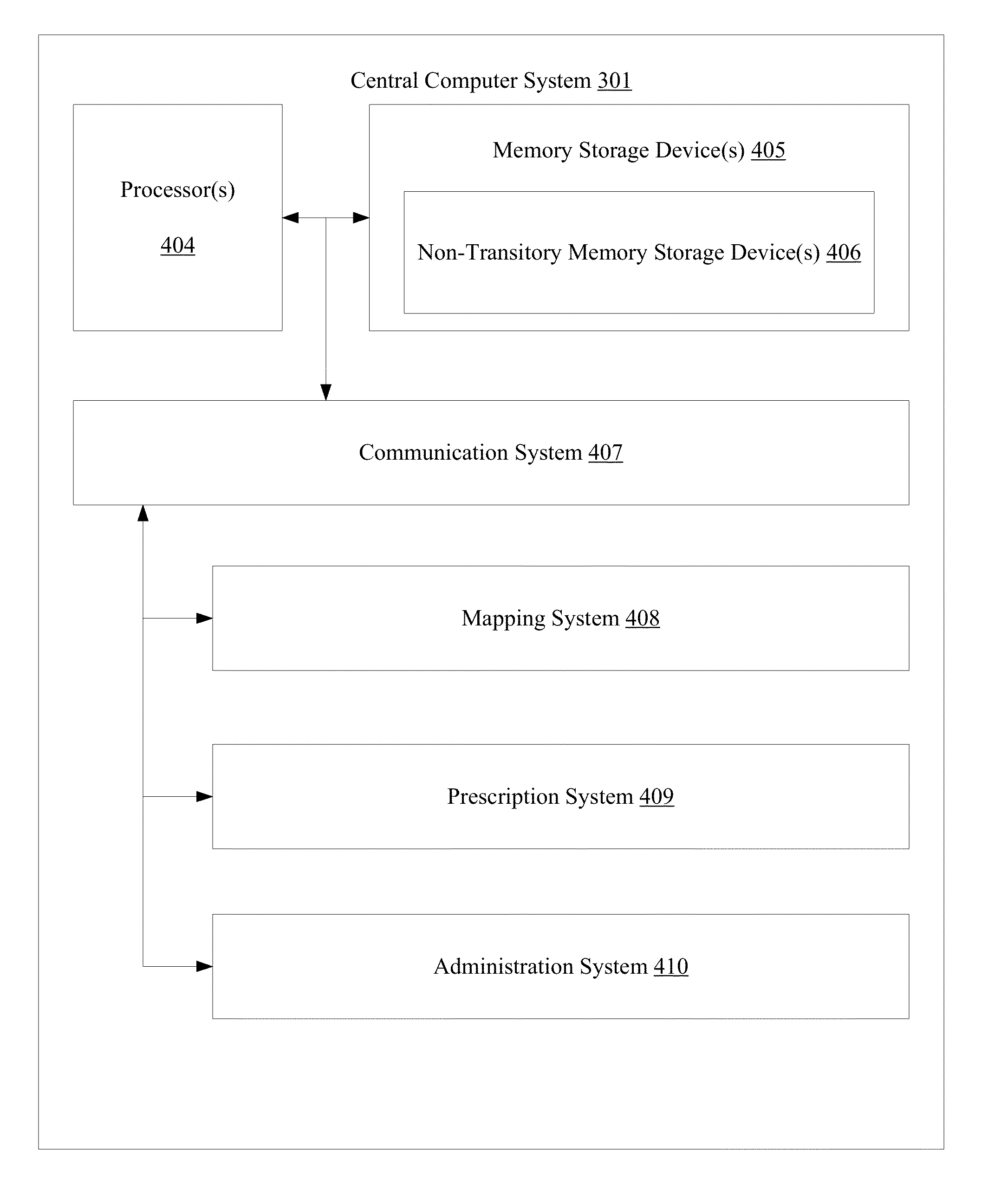