Methods and Devices For Determining The Location of Remotely Emplaced Objects, Such as Munitions

Active Publication Date: 2016-10-06
OMNITEK PARTNERS LLC
View PDF0 Cites 6 Cited by
  • Summary
  • Abstract
  • Description
  • Claims
  • Application Information

AI Technical Summary

Benefits of technology

[0033]12. Multi-cavity PGCOS enable individual emplaced objects to establish a directional link with the SPRS. This further reduces the power requirements and increases the signal to noise ratio.
[0034]13. Directional point to point links, which include an active return signal, eliminate multipath fading.
[0035]14. Since the SPRS has a very low profile with no protruding antennas the handling overhead an

Problems solved by technology

In particular, the use of high power beacons is undesirable in a battlefield environment as it is immediately visible to an enemy.
While this technology is proving useful in a controlled environment, its utilization for geolocation of EMs is fraught with difficulties.
RFID readers and tags are omnidirectional and thus require considerably more power during transmission compared with directional systems.
For the outdoor environment, coax cables could be replaced by a wireless link, but the technology is short range and heavily dependent on a large number of readers, which are essentially relatively high power and omnidirectional beacons, thereby making it unsuitable for many applications, including in the battlefield.
There does not appear to be a practical path to adaptation of this technology for EM geolocation application.
Wireless Wi-Fi sensor networks (WSN) suffer from the lack of localization technologies.
Deployment of wireless sensor node technology has some serious concerns in a non-cooperative battlefield environment.
In particular, the geolocation of EMs will be based on the relative location of other EMs, potentially leading to large positional uncertainties.
Main shortcoming of the WSN technology is the requirement of large number of widely dispersed base no

Method used


Image

  • Methods and Devices For Determining The Location of Remotely Emplaced Objects, Such as Munitions
  • Methods and Devices For Determining The Location of Remotely Emplaced Objects, Such as Munitions
  • Methods and Devices For Determining The Location of Remotely Emplaced Objects, Such as Munitions

Examples


Embodiment Construction

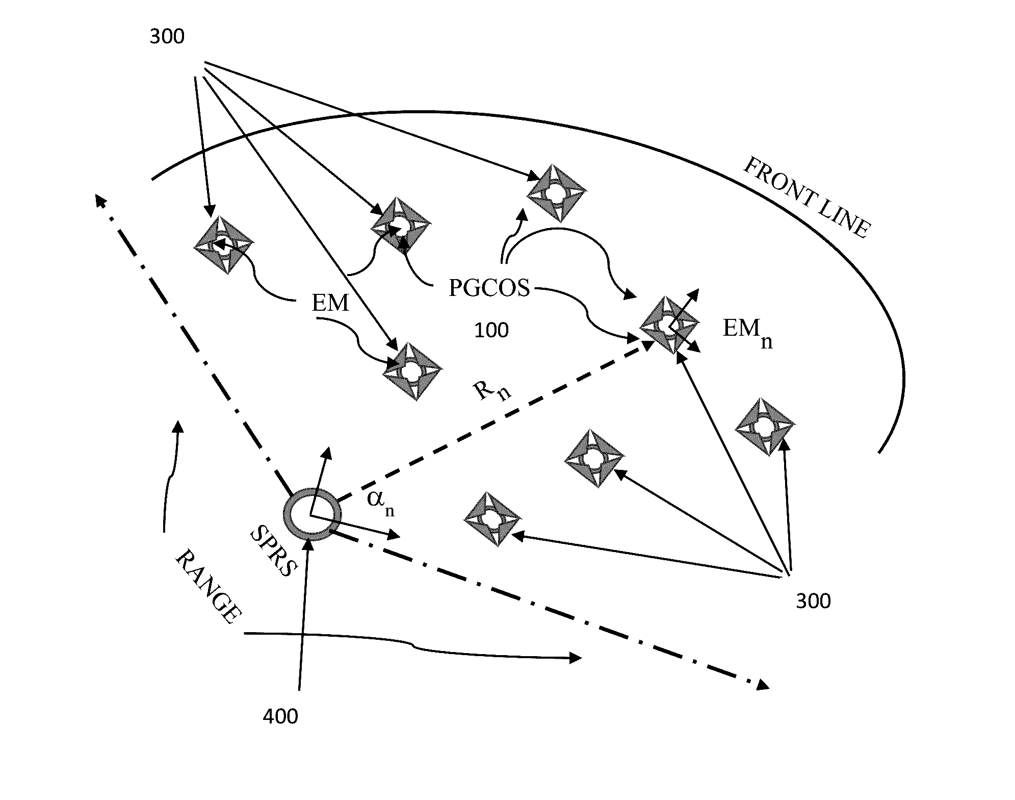
[0062]While the present methods and devices for determining the location of remotely emplaced objects may have particular utility with regard to determining the location of remotely emplaced munitions, such methods and devices for determining the location of remotely emplaced objects also have utility in determining the location of other objects, such as construction equipment, live animals / people (such as pets and toddlers), tracking and controlling driverless cars, collision avoidance systems for cars (whether or not they are driverless), whether such objects move with time or are fixed for certain periods. Thus, without limiting the applicability of the methods and devices for determining the location of remotely emplaced objects to munitions, the present disclosure will discuss embodiments with regard to determining the location of remotely emplaced munitions (EM).

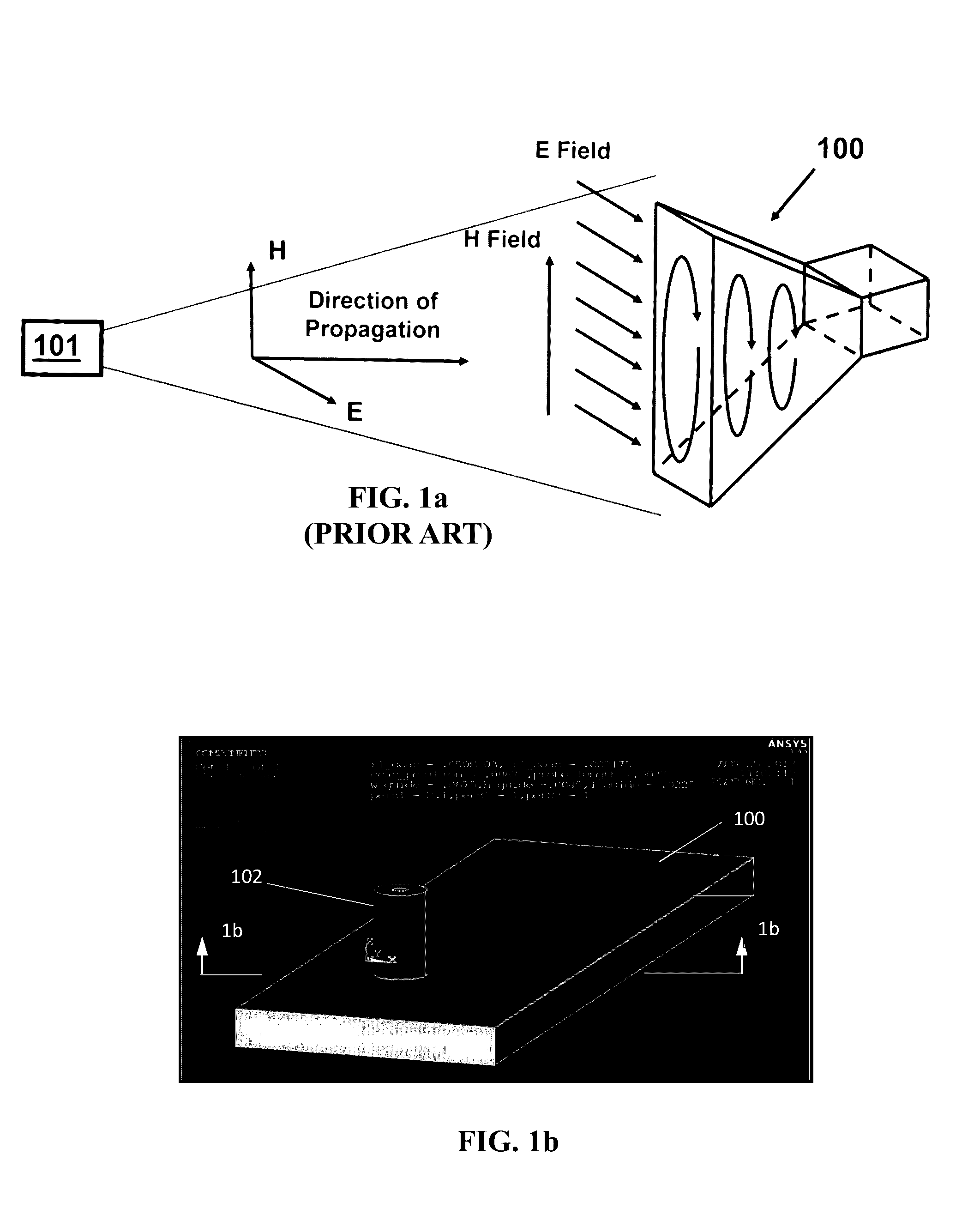
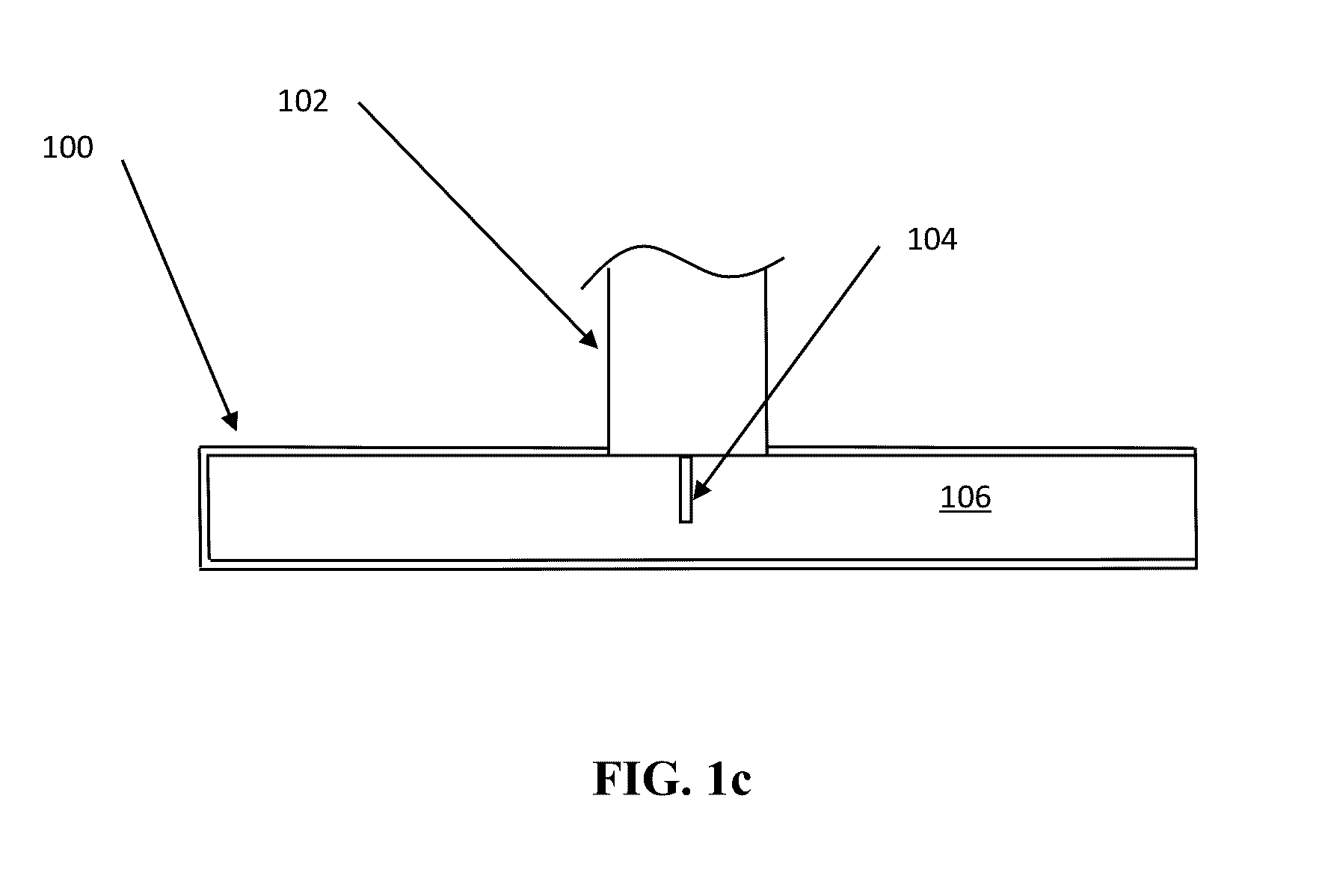
[0063]Briefly, referring to FIG. 1a, there is shown a representation of a waveguide sensor (PGCOS) 100 and its opera...


PUM


Abstract

A method for determining a location of remotely emplaced objects. The method including: (a) scanning a field for one or more remotely emplaced objects with a reference source signal from a reference source; (b) detecting the signal at one or more orientation sensors associated with each of the one or more remotely emplaced objects; (c) determining an angular direction of each of the one or more remotely emplaced objects relative to the reference source based on the signal received at the one or more orientation sensors associated with each of the one or more remotely emplaced objects; (d) directing a range signal from the reference source towards each of the remotely emplaced objects at a corresponding determined angular direction; (e) in response to the range signal, transmitting a response signal from each of the remotely emplaced objects to the reference source; and (f) determining a range for each of the one or more remotely emplaced objects relative to the reference source at the determined angular direction based at least partially on the range and response signals.

Description

CROSS REFERENCE TO RELATED APPLICATION[0001]This application claims priority to U.S. Provisional Application No. 62 / 129,792, filed on Mar. 7, 2015, the entire contents of which are incorporated herein by reference.BACKGROUND OF THE INVENTION[0002]1. Field of the Invention[0003]The present invention relates to determining the location of remotely emplaced objects, and in particular, to methods and devices for determining the location of remotely emplaced objects, such as munitions.[0004]2. Prior Art[0005]Geolocation and navigation in GPS denied environments, particularly indoors, has attracted the interest of researchers from very diverse fields. Many of the contemporary technologies are based on trilateration, triangulation, received signal strength, signal-of-opportunity, and frequency of arrival. The latter requires relative motion between the target and the known source. Trilateration requires highly accurate clocks and time synchronization, while triangulation requires precise k...

Claims


Application Information

Patent Timeline
IPC IPC(8): G01S5/02
CPCG01S5/0221G01S5/0252G01S13/88G01S13/751
Inventor RASTEGAR, JAHANGIR SDHADWAL, HARBANS
Owner OMNITEK PARTNERS LLC
Why Eureka
Try Eureka