Ponding water detection on satellite imagery

a satellite imagery and ponding technology, applied in scene recognition, television systems, instruments, etc., can solve the problems of severe damage or total loss, overwatering of crops, and water being extremely detrimental to the growth of certain crops

Active Publication Date: 2017-03-23
THE CLIMATE CORP
View PDF2 Cites 82 Cited by
  • Summary
  • Abstract
  • Description
  • Claims
  • Application Information

AI Technical Summary

Problems solved by technology

Although ponding water typically dissipates after some time, either through evaporation or absorption into the soil, in the meantime ponding water can be extremely detrimental to the growth of certain crops.
For example, the ponding water may be pooled on top of the crops and cause the crops to become overwatered.
Newly emerged seedlings, or crops such as turf grass that are short even at maturity, can become inundated and oxygen starved, resulting in severe damage or total loss under the ponded area.
This is especially dangerous during early growing seasons when overwatering can cause a drastic decrease in crop yield come harvest.
However, modern farms can span extremely large areas and it may not be practical to physically visit all the potential areas where ponding water might appear.
However, such techniques translate poorly to detecting within-field ponding water.
There are many challenges to differentiating water signals from other land cover signals in remotely sensed data, such as satellite imagery data.
Another issue comes from the fact that most high-resolution remote sensing imagery is not atmospherically corrected, so that the water content or aerosol depth impacts the sensed signals.
Given these issues, within-field ponding water detection becomes an extremely challenging problem.

Method used


Image

  • Ponding water detection on satellite imagery
  • Ponding water detection on satellite imagery
  • Ponding water detection on satellite imagery

Examples


Embodiment Construction

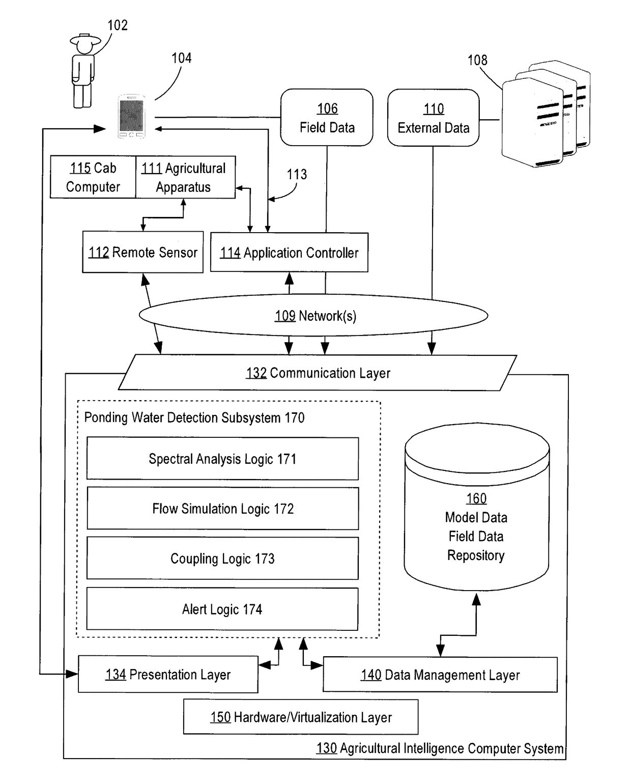
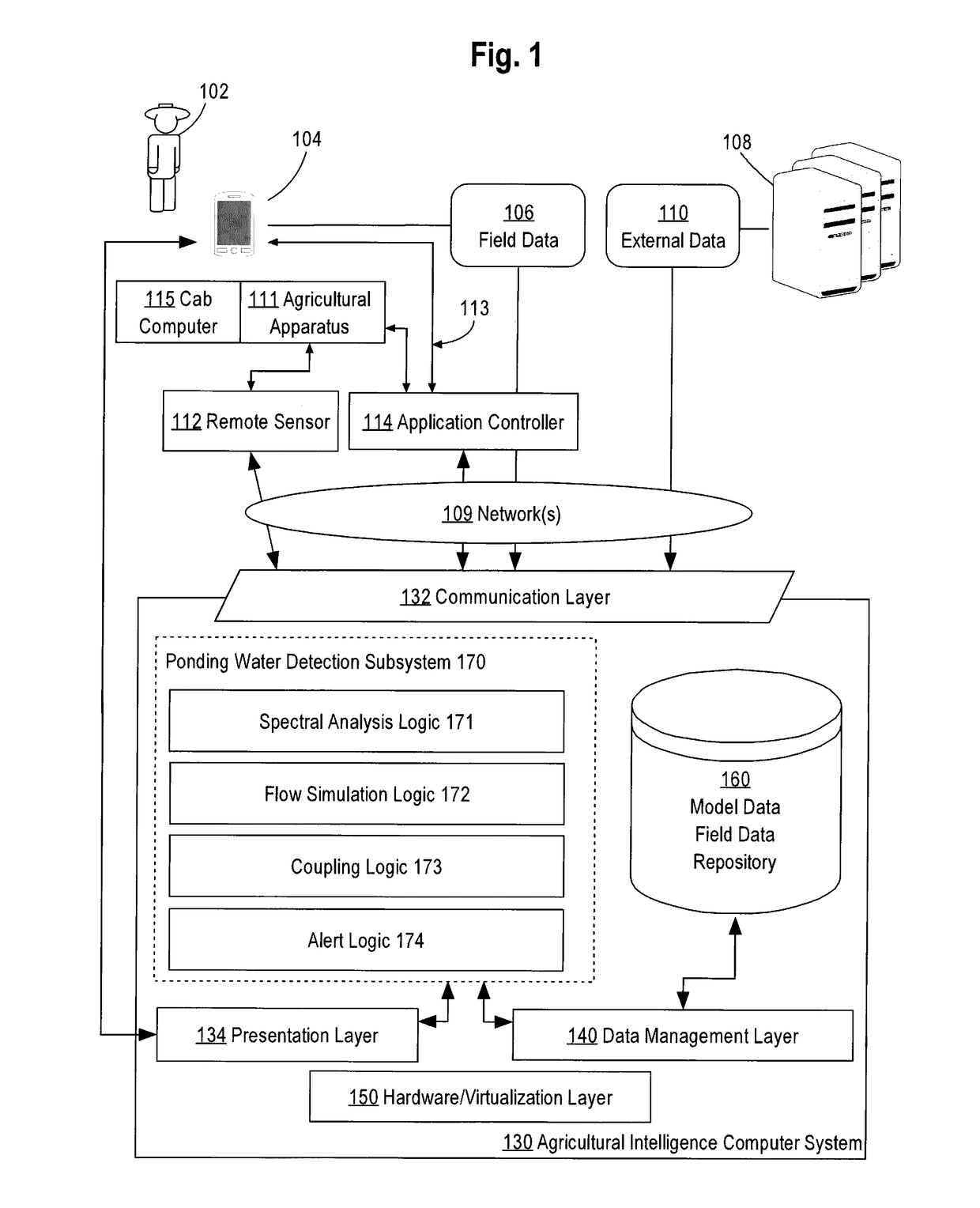
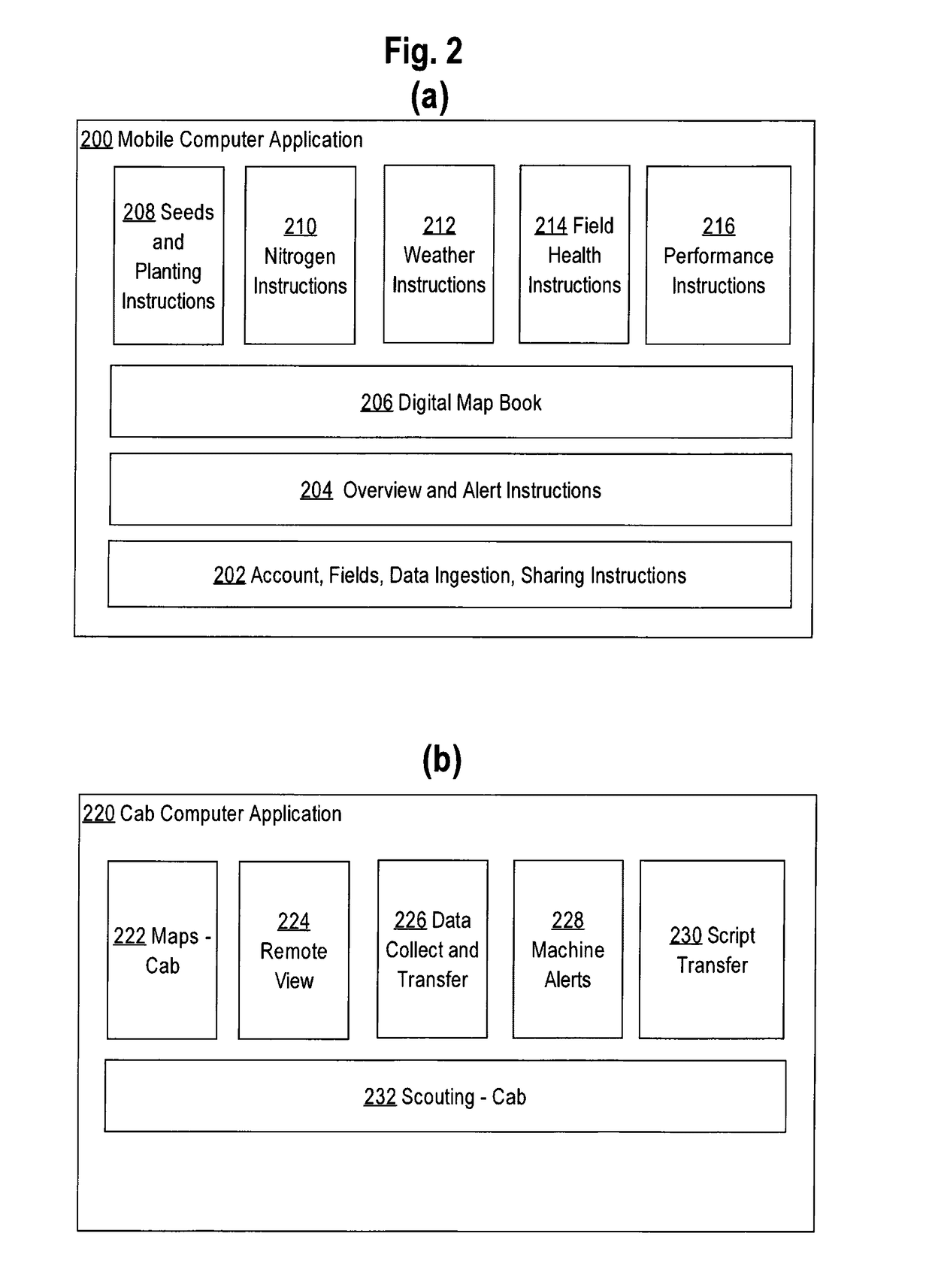
[0017]In the following description, for the purposes of explanation, numerous specific details are set forth in order to provide a thorough understanding of the present disclosure. It will be apparent, however, that embodiments may be practiced without these specific details. In other instances, well-known structures and devices are shown in block diagram form in order to avoid unnecessarily obscuring the present disclosure. The description is provided according to the following outline:[0018]1.0 General Overview[0019]2.0 Example Agricultural Intelligence Computer System[0020]2.1 Structural Overview[0021]2.2 Application Program Overview[0022]2.3 Data Ingest to the Computer System[0023]2.4 Process Overview—Agronomic Model Training[0024]2.5 Ponding Water Detection Subsystem[0025]2.6 Implementation Example—Hardware Overview[0026]3.0 Example System Inputs[0027]3.1 Remote Sensing Data[0028]3.2 Precipitation Data[0029]3.3 Elevation Data[0030]3.4 Soil Property Data[0031]3.5 Cropland Data[0...


PUM


Abstract

A system for identifying ponding water located on a field from image data is described. In an approach, an image of an agricultural field is analyzed using a classifier that has been trained based on the spectral bands of labeled image pixels to identify a probability for each pixel within the image that the pixel corresponds to water. A flow simulation is performed to determine regions of the field that are likely to pool water after rainfall based on precipitation data, elevation data, and soil property data of the field. A graph of vertices representing the pixels and edges representing connections between neighboring pixels is generated. The probability of each pixel within the graph being ponding water is set based on the probability pixel being water, the likelihood that water will pool in the area represented by the pixel, the probability of neighboring pixels being ponding water, and a cropland mask that identifies which pixels correspond to cropland. A class for each pixel is then determined that maximizes the joint probability over the graph.

Description

COPYRIGHT NOTICE[0001]A portion of the disclosure of this patent document contains material which is subject to copyright protection. The copyright owner has no objection to the facsimile reproduction by anyone of the patent document or the patent disclosure, as it appears in the Patent and Trademark Office patent file or records, but otherwise reserves all copyright or rights whatsoever. © 2015 The Climate Corporation.FIELD OF THE DISCLOSURE[0002]The present disclosure relates to detecting ponding water within agricultural fields using programmed computer systems to analyze digital images. More specifically, the present disclosure relates to detecting ponding water within agricultural fields by analyzing satellite imagery of said agricultural fields.BACKGROUND[0003]The approaches described in this section are approaches that could be pursued, but not necessarily approaches that have been previously conceived or pursued. Therefore, unless otherwise indicated, it should not be assume...

Claims


Application Information

Patent Timeline
Patent Type & Authority Applications(United States)
IPC IPC(8): G06K9/00G08B21/18H04N5/232H04N7/18H04N5/28
CPCG06K9/0063H04N7/185G08B21/182H04N5/23238H04N5/28G06V20/194G06V20/188A01G7/00G06T7/00G06T3/0031
Inventor GUAN, WEIKHADKA, PRAMITHUS
Owner THE CLIMATE CORP
Why Eureka
Try Eureka