Positioning and navigation receiver with a confidence index

Active Publication Date: 2017-07-13
CENT NAT DETUD SPATIALES C N E S
View PDF1 Cites 1 Cited by
  • Summary
  • Abstract
  • Description
  • Claims
  • Application Information

AI Technical Summary

Benefits of technology

The invention is a GNSS signal reception system that allows for precise position measurement and processing operations based on the current and future needs of the user. The precision information is delivered to the user continuously, either in graphical or numerical form. The system is also flexible and can be adapted to different hardware and software configurations and can be combined with multiple constellations, correction broadcasting systems, and telecommunications systems. Additionally, the receiver of the invention includes a Kalman filter that can integrate errors due to various effects, such as signal loss, to ensure better continuity of the localization process.

Problems solved by technology

The calculation of the PVT data by a receiver from signals from satellites is affected by many errors of various types: the impact of the passage by the electromagnetic signals through the various layers of the atmosphere (troposphere, ionosphere), errors due to reflection of the signals from objects in the vicinity of the receiver (multipaths), clock errors, errors in the electronic processing circuits, etc.
However these solutions are restricted and expensive.
In the case of actual use, buildings, trees, and other elements of the environment will greatly degrade the reception and processing conditions of the positioning signals.
Therefore, the measurements will be less good, to the point of causing the signal to be lost.
Thus, no prior-art system allows, at the present time, a measurement precision to be determined for the current and future position of a receiver of navigation signals depending on the hardware and software configuration of the receiver and its current position, so as to adapt, if needs be, the processing of the signals to obtain a given precision.

Method used


Image

  • Positioning and navigation receiver with a confidence index
  • Positioning and navigation receiver with a confidence index
  • Positioning and navigation receiver with a confidence index

Examples


Embodiment Construction

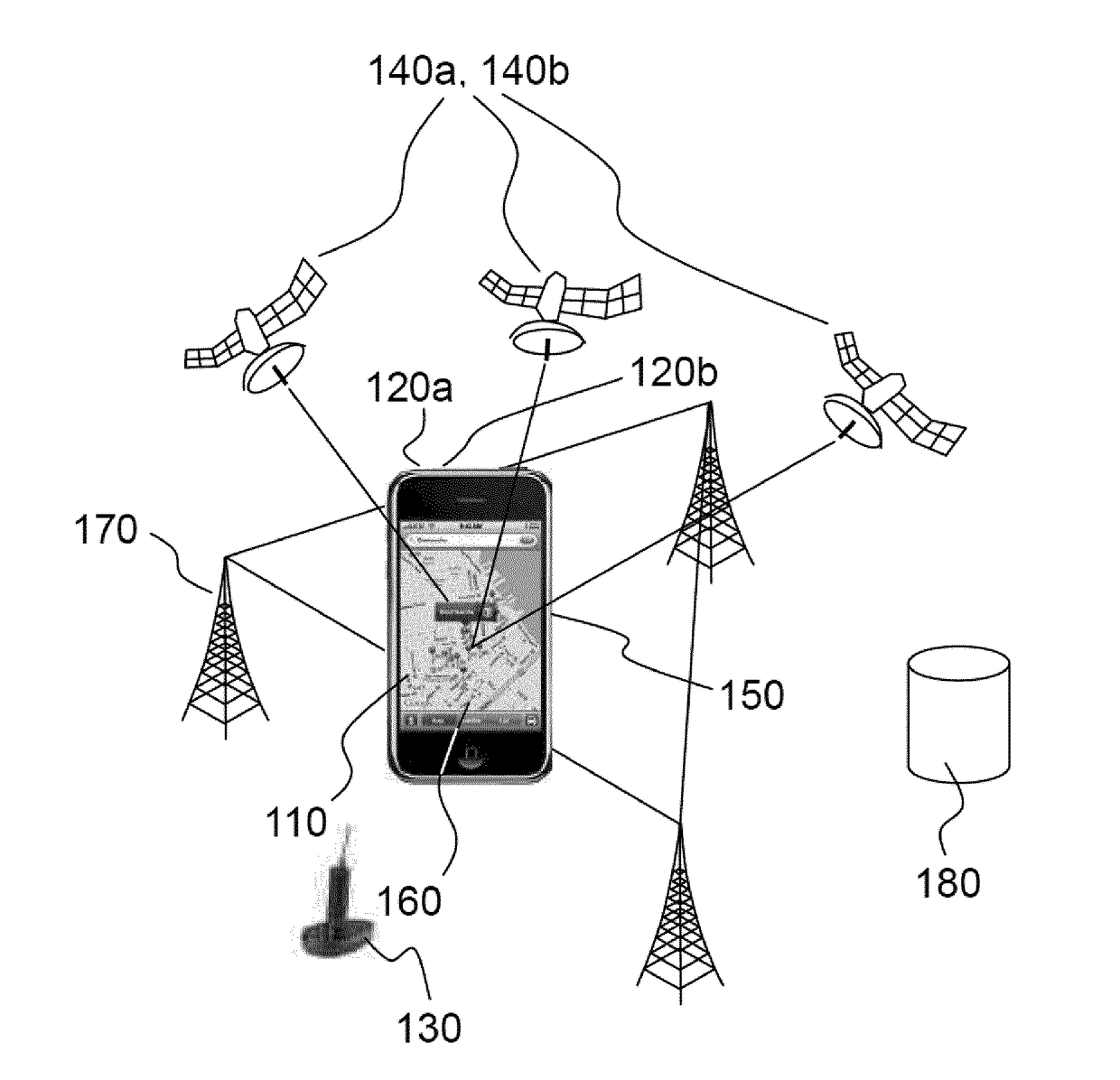
[0039]FIG. 1 illustrates an architecture of a system configured to implement the invention in a plurality of its embodiments.

[0040]There are many different types of GNSS receivers, which may be relatively compact. By way of purely illustrative and nonlimiting example of the field of application of the invention, FIG. 1 shows a terminal consisting of a smartphone 110 provided with functionalities allowing signals to be acquired from at least one satellite navigation constellation 140. The terminal must be equipped with a specific antenna 120a, 120b to acquire the one or more signals from the satellites. It is possible to provide an exterior antenna 130 that improves the conditions of acquisition and tracking of the navigation signal. The interior antenna and the remote antenna may be mono-, bi- or tri-frequency antennae. The position of the remote antenna is chosen to optimize reception (notably for an automotive vehicle, a boat or an aeroplane) and may be mounted in a radome to limi...


PUM


Abstract

The positioning receiver according to the invention comprises means for storing configuration information and information on its reception conditions, which is processed in order to calculate a current and / or predicted precision of the positioning calculation. Advantageously, at least some of this information is integrated into a variation model of a Kalman filter integrated into the receiver. The invention notably allows a more rapid convergence on a reference precision in a mono-frequency operating mode and transitions between a mono-frequency and bi-frequency mode to be smoothed. Advantageously, the precision information is delivered graphically or in numerical form to the user.

Description

FIELD OF THE INVENTION[0001]The present invention relates to satellite navigation systems. More precisely, the aim of the invention is to produce information allowing the precision that may be guaranteed by a system depending on present and future operating conditions to be predicted, given the hardware and software configuration of the receiver of a user.BACKGROUND[0002]The first satellite constellation emitting positioning signals was put in place for military applications by the American state (global positioning system or GPS) from the start of the eighties. Since then, GPS signals have been used by professional civil applications (management of fleets of trucks, aerial navigation aids, geodetic surveys, etc.) and more recently in mass-market applications (automotive navigation with on-board terminals and pedestrian navigation with smartphone type terminals). Other constellations have been put in place by the Russian state (GLONASS) and Chinese state (Baïdou). A European satelli...

Claims


Application Information

Patent Timeline
IPC IPC(8): G01S19/37G01S19/27
CPCG01S19/27G01S19/37G01S19/393G01S19/396G01S19/39
Inventor LAURICHESSE, DENIS
Owner CENT NAT DETUD SPATIALES C N E S
Why Eureka
Try Eureka