System and method for semantic simultaneous localization and mapping of static and dynamic objects

Inactive Publication Date: 2018-06-14
CHARLES STARK DRAPER LABORATORY
View PDF0 Cites 66 Cited by
  • Summary
  • Abstract
  • Description
  • Claims
  • Application Information

AI Technical Summary

Benefits of technology

[0007]The present invention overcomes disadvantages of the prior art by providing an object-based SLAM approach that defines a novel paradigm for simultaneous semantic tracking, object registration, and mapping (referred to herein as the system and method/process, “STORM”) according to an illustrative embodiment. While building a dense map of a dynamic environment, STORM identifies and tracks objects and localizes its sensor in the map. In contrast to most SLAM approaches, STORM models the trajectories of objects rather than assuming the objects rem

Problems solved by technology

Additionally, the object detection system suffers from the same inherent issues as bag-of-words-based models, ignoring spatial information between visual words (See Appendix item [12]).
However, this approach does not leverage the semantic knowledge to improve localization and mapping.
However, this technique cannot handle moving or repetitive objects.
None of these approaches leverage prior semantic knowledge of objects mobility and identity to self-localize in an environment.
However, SLAMMOT creates sparse 2D maps that are insufficient for tasks using the map such as

Method used


Image

  • System and method for semantic simultaneous localization and mapping of static and dynamic objects
  • System and method for semantic simultaneous localization and mapping of static and dynamic objects
  • System and method for semantic simultaneous localization and mapping of static and dynamic objects

Examples


Embodiment Construction
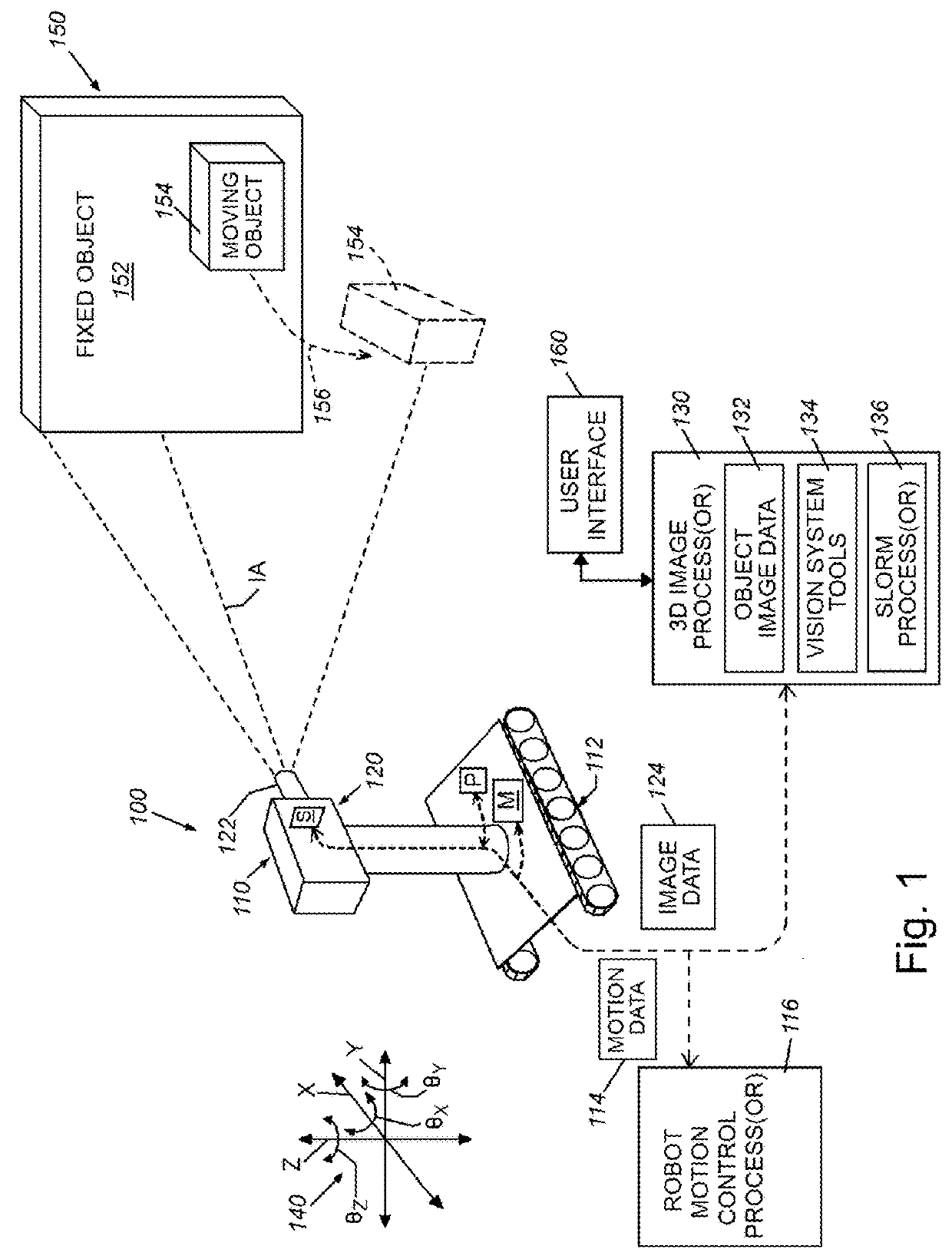
A. System Overview

[0016]In various embodiments, the present invention can provide a novel solution that can simultaneously localize a robot equipped with a depth vision sensor and create a tri-dimensional (3D) map made only of surrounding objects. This innovation finds applicability in areas like autonomous vehicles, unmanned aerial robots, augmented reality and interactive gaming, assistive technology.

[0017]Compared to existing Simultaneous Localization and Mapping (SLAM) approaches, the present invention of Simultaneous Tracking (or “localization”), Object Registration, and Mapping (STORM) can maintain a world map made of objects rather than 3D cloud of points, thus considerably reducing the computational resources required. Furthermore, the present invention can learn in real time the semantic properties of objects, such as the range of mobility or stasis in a certain environment (a chair moves more than a book shelf). This semantic information can be used at run time by the robo...


PUM


Abstract

A system for Semantic Simultaneous Tracking, Object Registration, and 3D Mapping (STORM) can maintain a world map made of static and dynamic objects rather than 3D clouds of points, and can learn in real time semantic properties of objects, such as their mobility in a certain environment. This semantic information can be used by a robot to improve its navigation and localization capabilities by relying more on static objects than on movable objects for estimating location and orientation.

Description

FIELD OF THE INVENTION[0001]This invention relates to camera-based vision systems, and more particularly to robotic vision systems used to identify and localize three-dimensional (3D) objects within a scene, build a map of the environment imaged by a sensor of a robot or other camera-guided device, and localize that sensor / device in the map.BACKGROUND OF THE INVENTION[0002]For an autonomous mobile robot, building an accurate map of its surroundings and localizing itself in the map are critical capabilities for intelligent operation in an unknown environment using sensor data. Such sensor data can be generated from one or more types of sensors that sense (e.g.) visible and non-visible light, sound or other media reflected from the object in an active or passive mode. The sensor data received is thereby defined as point clouds, three-dimensional (3D) range images or any other form that characterizes objects in a 3D environment. This problem has been the focus of robotics research for ...

Claims


Application Information

Patent Timeline
IPC IPC(8): B25J9/16G06T7/73G06T17/05G06K9/00G06V10/84
CPCB25J9/1697G06T7/75G06T17/05G06K9/00671G06V20/10G06V10/82G06V10/84G06N3/045G06F18/29G06V20/20
Inventor KEE, VINCENT P.MARIOTTINI, GIAN LUCA
Owner CHARLES STARK DRAPER LABORATORY
Why Eureka
Try Eureka