Slam method and apparatus robust to wireless environment change

a wireless environment and wireless technology, applied in the field of slam methods and apparatuses, can solve the problems of low resolution, low resolution, and high cost of a very high resolution, and achieve the effect of accurately estimating reducing time and cost consumed in map creation, and accurate estimation of the position of the moving nod

Active Publication Date: 2020-01-30
KOREA INST OF SCI & TECH
View PDF0 Cites 16 Cited by
  • Summary
  • Abstract
  • Description
  • Claims
  • Application Information

AI Technical Summary

Benefits of technology

[0028]a relative position of a moving node is estimated based on motion sensing of the moving node, the relative position of the moving node is corrected based on a comparison between a change pattern of at least one signal strength received over a plurality of time points and a signal strength distribution in a region in which the moving node is located, a route of the region is represented by using the relative position corrected as described above, and thereby, it is possible accurately estimate a position of the moving node and to create a map in which very accurate route information is recorded throughout the entire region at the same time, even if a wireless environment change such as signal interference between communication channels, expansion of an access point, and occurrence of a failure or an obstacle is made or a poor wireless environment such as lack of the number of access points occurs. In this way, since position estimation of the moving node and map creation can be performed at the same time, time and cost consumed in the map creation can be greatly reduced compared with a method in which a person directly collects terrain information or signal information.
[0029]A reception position of the moving node is estimated for at least one signal received at a current time point among a plurality of time points, based on a comparison between a change pattern of at least one signal strength received over the plurality of time points and signal strength distribution in a region where the moving node is located, a coordinate value of a relative position of the moving node is corrected by using a coordinate value of the reception position estimated in this way, and thereby, it is possible to accurately estimate a position of the moving node and to simultaneously create a map in which very accurate route information is recorded throughout the entire region by performing mutual complementing between defects in the relative localization and defects in the wireless localization even in various environment changes such as a wireless environment change and a route change.
[0030]Unlike the SLAM of related art, a physical landmark is not required, and instead, similarity between a change pattern

Problems solved by technology

The LiDAR has a very high resolution but is expensive and hard to be applied to a small and light device such as a smartphone due to a limitation in miniaturization.
In the same manner, the camera is hard to be applied to the smartphone having a low image data processing capability because the camera outputs image data.
The ultrasonic sensor can be miniaturized, but has a very low resolution, and thereby, there is a limitation to create a map with high accuracy.
Due to this, the SLAM is attracting attention for a special purpose such as a moving robot put in a disaster region but is not attracting attention for creating a map for localization of a navigation system of a smartphone or a vehicle except for the moving robot.
The map of related art has a problem that takes a lot of time and cost to create a map because a person creates the map by collecting terrain information or signal information while moving around a region in which a localization service is provided.
Particularly, the GPS cannot perform the localization in an indoor space where a radio wave emitted from a satellite cannot reach, and there is a problem that accuracy of the localization in a city is seriously decreased due to blocking, reflection or the like of the radio wave by a high-rise building.
However, partial autonomous driving in an outdoor space makes some results, but autonomous driving in the indoor space and the outdoor space is still impossible due to inability of an indoor localization of the GPS.
The wireless localization technology is currently being commercialized and serviced, but localization accuracy is very low compared with the GPS, and thus, various

Method used


Image

  • Slam method and apparatus robust to wireless environment change
  • Slam method and apparatus robust to wireless environment change
  • Slam method and apparatus robust to wireless environment change

Examples


Embodiment Construction

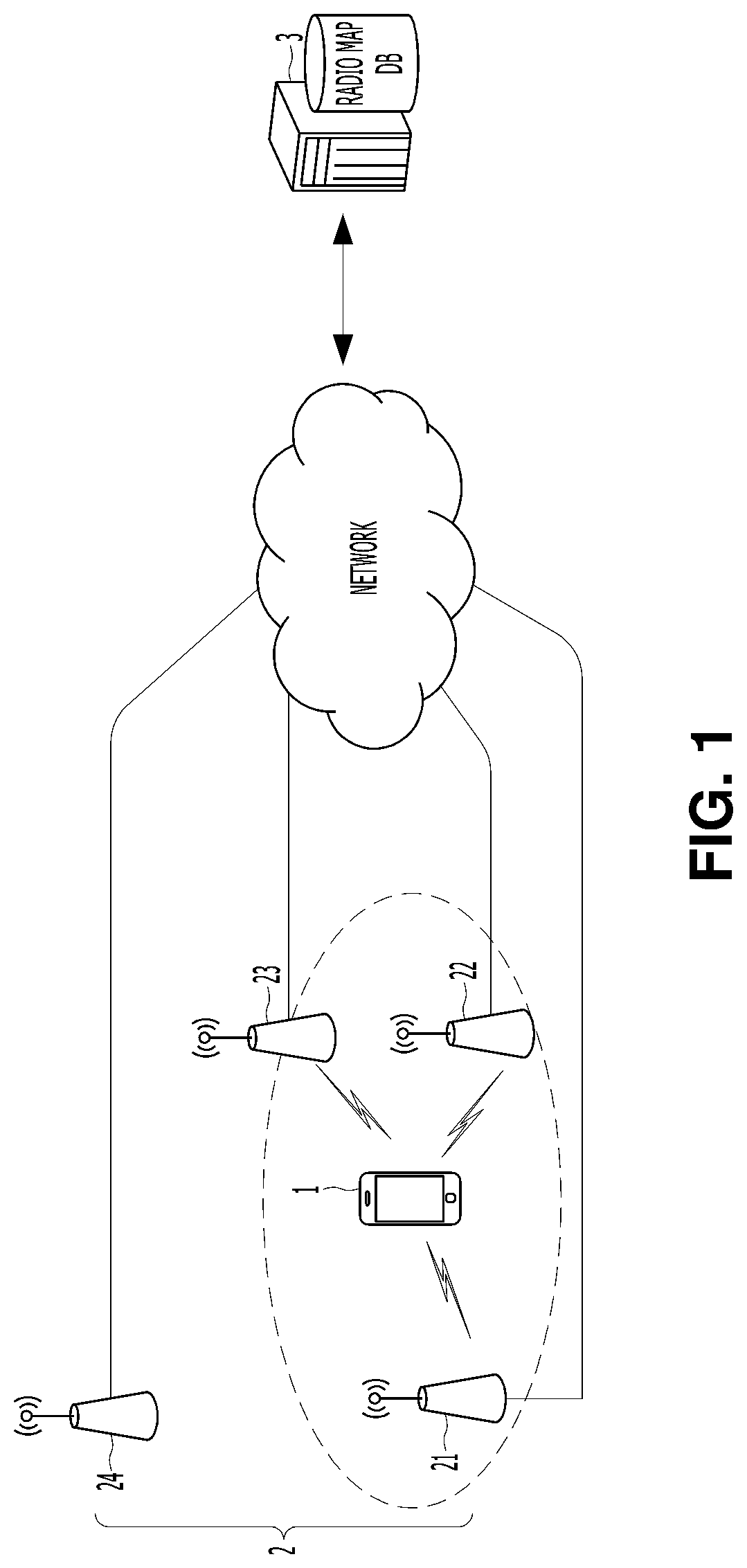
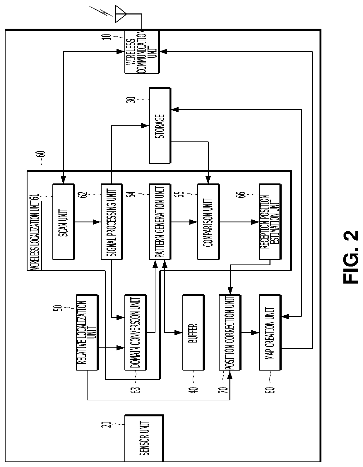
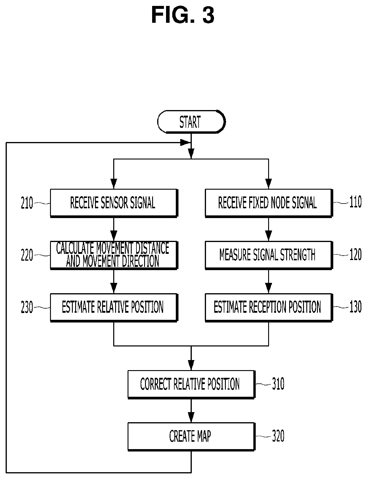
[0048]Hereinafter, embodiments of the present invention will be described in detail with reference to the drawings. Hereinafter, all moving objects, which are localization targets, such as a smartphone carried by a user, a navigation system mounted on a vehicle, and a moving robot that moves by itself as an independent object will be collectively referred to as a moving node. In addition, communication devices, which are fixedly installed in regions and relay wireless communication of a moving node, such as an access point (AP) of a WiFi network and a base station of an LTE network, will be collectively referred to as a “fixed node”. In addition, a radio frequency (RF) signal transmitted from the fixed node will be briefly referred to as a “signal”.

[0049]An embodiment of the present invention that will be described below relates to simultaneous localization and mapping (SLAM) method and apparatus which can estimate a position of a moving node in an unknown environment and create a m...


PUM


Abstract

The present invention relates to SLAM (simultaneous localization and mapping) method and apparatus robust to a wireless environment change. A relative position of a moving node is estimated based on motion sensing of the moving node, the relative position of the moving node is corrected based on a comparison between a change pattern of at least one signal strength received over a plurality of time points and a signal strength distribution in a region in which the moving node is located, a route of the region is represented by using the relative position corrected as described above, and thereby, it is possible accurately estimate a position of the moving node and to create a map in which very accurate route information is recorded throughout the entire region at the same time, even if a wireless environment change such as signal interference between communication channels, expansion of an access point, and occurrence of a failure or an obstacle is made or a poor wireless environment such as lack of the number of access points occurs.

Description

TECHNICAL FIELD[0001]The present invention relates to SLAM method and apparatus which can estimate a position of a moving node in an unknown environment and simultaneously create a map for the unknown environment.BACKGROUND ART[0002]Recently, interest in a simultaneous localization and mapping (SLAM) technology is increasing in a field of moving robot such as a drone. SLAM is a technology for creating a map for the unknown environment while a robot walks around and recognizes a position thereof using only a sensor attached to the robot without external help, and emerges as a key technology for an autonomous navigation. SLAM of related art estimates a position of a moving robot on the basis of several physical landmarks. In order to identify the landmarks, a sensor such as a LiDAR, a camera, or an ultrasonic sensor is required.[0003]The LiDAR has a very high resolution but is expensive and hard to be applied to a small and light device such as a smartphone due to a limitation in mini...

Claims


Application Information

Patent Timeline
IPC IPC(8): G01S11/06G01S5/02
CPCG01S11/06G01S5/0252H04W64/00H04W88/18G05D1/02G01S5/0264G01S5/02526G01S5/021G05D1/0274H04W64/006
Inventor LEE, TAIKJINJHON, YOUNGMINKIM, JAEHUNSEO, MINAHSHIN, BEOMJU
Owner KOREA INST OF SCI & TECH
Why Eureka
Try Eureka