Process for correcting atmospheric influences in multispectral optical remote sensing data

a multi-spectral optical and remote sensing data technology, applied in image enhancement, scene recognition, instruments, etc., can solve the problems of inability to use automatic atmospheric correction of remotely sensed data, inability to automatically identify validation areas, and inability to routine automatic processing of multi-spectral remote sensing data from a wide variety of sensors, etc., to achieve precise correction calculation, good time-space correlation of atmospheric data, inventive process fast

Inactive Publication Date: 2002-11-19
DEUTSCHES ZENTRUM FUER LUFT & RAUMFAHRT EV
View PDF3 Cites 57 Cited by
  • Summary
  • Abstract
  • Description
  • Claims
  • Application Information

AI Technical Summary

Benefits of technology

In accordance with the invention, which relates to a process of the above type, this aim is met in such a way that in a first partial process, a pre-classification of the raw data takes place for an automatic recognition of predefined classes, that, in a second partial process, a correction calculation is performed to convert the uncorrected reflectances into corrected reflectances on the ground, and that current and essentially complete supplementary data on the current atmospheric conditions are incorporated. The pre-classification permits a more precise correction calculation by generating required a priori knowledge.
Pre-tabulated / parameterized radiative transfer calculations make the inventive process fast and, therefore, suitable for operational applications. To attain a good time-space correlation of the atmospheric data with the data in need of correction, these values are estimated, as far as possible, from the data in need of correction. Additional supplementary data that cannot be obtained from the data in need of correction can be acquired externally from operational processing chains via an external interface, and interpolated with suitable methods.

Problems solved by technology

Popp: Correcting atmospheric masking to retrieve the spectral albedo of land surfaces from satellite measurements, Int. J. Rem. Sens., 16, pages 3483-3508, 1995), which does not permit a routine automatic processing of multispectral remote sensing data from a great variety of sensors.
These processes, therefore, cannot be used for an automatic atmospheric correction of remotely sensed data.
Furthermore, until now there is no automatic identification of validation areas, e.g., of reference areas of a low reflectance and of areas of known reflectance behavior.
Furthermore, in the known industrial samples and most laboratory samples, the anisotropy of the reflectance on the ground is not taken into consideration.
A further, hitherto unsolved problem in the processing of remotely sensed data lies in the fact that, while it is true that measurements of the current atmospheric condition can be incorporated for the correction of individual data sets, as a rule, a large-scale incorporation of current atmospheric parameters can not take place within these processes.

Method used


Image

  • Process for correcting atmospheric influences in multispectral optical remote sensing data
  • Process for correcting atmospheric influences in multispectral optical remote sensing data

Examples


Embodiment Construction

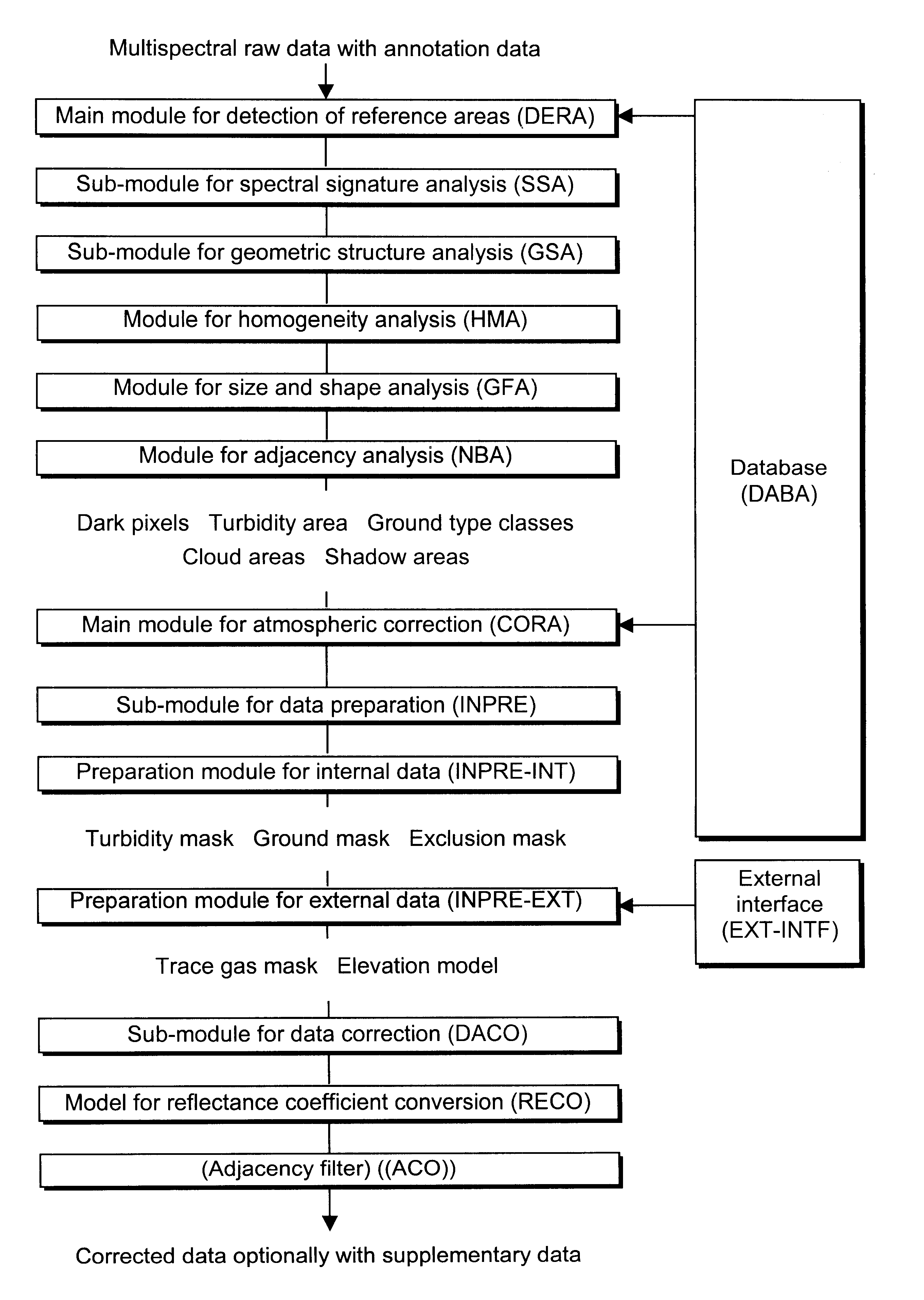
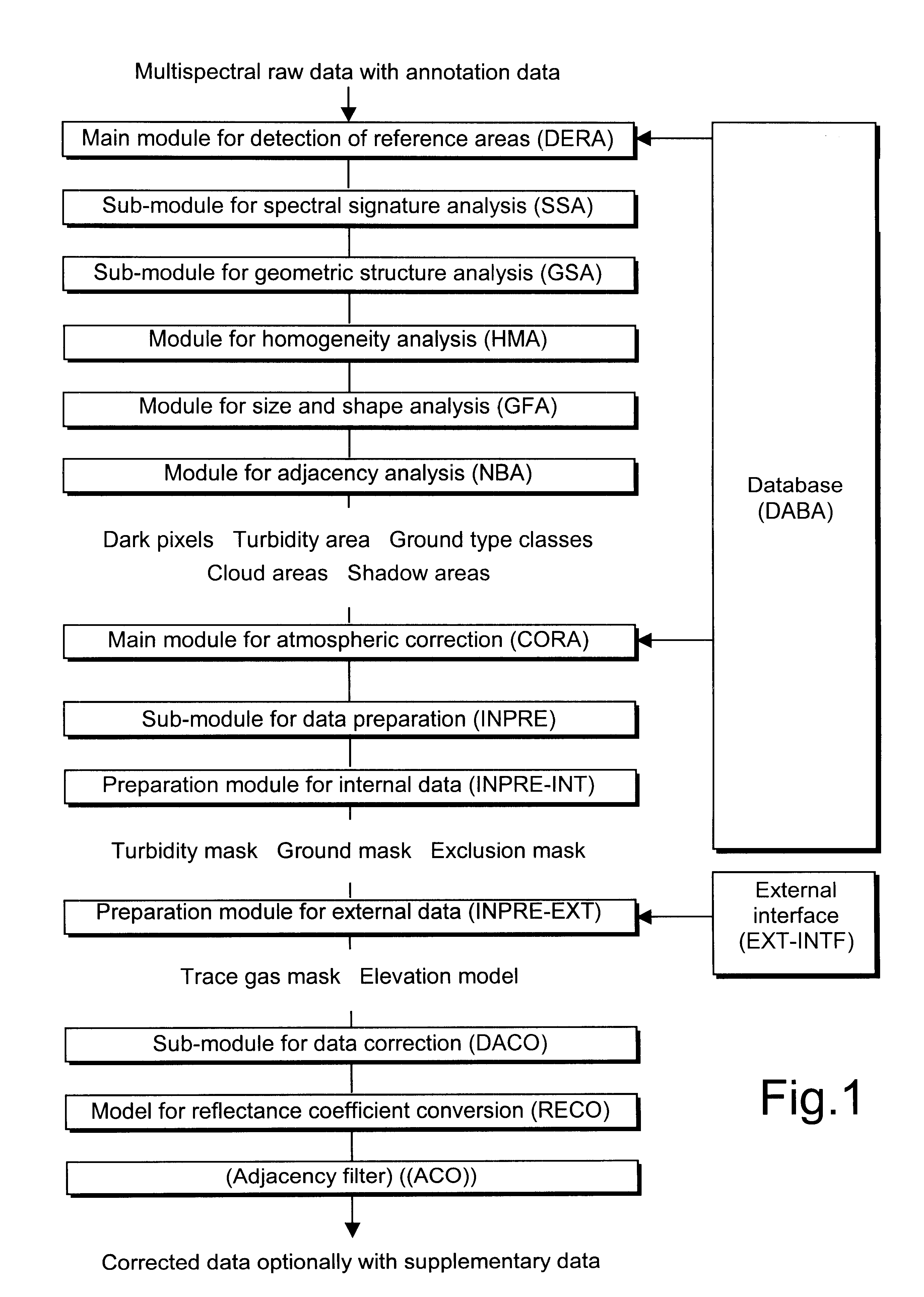
The process shown in the FIGURE for an automatic atmospheric correction according to the invention consists of two different partial processes, which are combined as main modules DERA and CORA. The main module DERA ("Detection of Reference Areas") is used for the detection and identification of dark areas and areas of significant spectral behavior in the remotely sensed data, and the main module CORA ("Correction of Atmosphere") is used for the atmospheric correction of the remotely sensed data. Both main modules DERA and CORA access a database DABA with stored methods and parameters. The process provides the result in the form of a pixel image of the atmosphere-corrected ground reflectance with incorporated supplementary atmospheric data, anisotropic reflectance characteristics of different ground type classes, and terrain elevation. Data from different sensors with different geometric and / or spectral resolutions can be read in as raw data and processed.

The main module DERA consist...


PUM


Abstract

The inventive process for correcting atmospheric influences in multispectral optical remote sensing data, which are acquired as raw data in satellite or airborne sensors for earth observation, comprises the combination of a pre-classification (DERA) of the raw data for an automatic identification of predefined classes, a correction calculation (CORA) for a conversion of the uncorrected to corrected reflectances on the ground, including an incorporation of current atmospheric data for a precise description of the atmospheric condition. The pre-classification (DERA) permits a more precise correction calculation (CORA) by generating required a priori knowledge. The method has applications in satellite or airborne remote sensing of the earth's surface.

Description

1. Technical Field of the InventionThe present invention relates to a process for correcting atmospheric influences in multispectral optical remote sensing data that are acquired in different types of satellite or airborne sensors for earth observation with different geometric and / or spectral resolutions, and read in and precessed as raw data to generate an image.2. Prior ArtA fundamental prerequisite for deriving quantitative parameters and indicators from remotely sensed data, apart from geo-referencing, is the atmospheric correction.A number of basic processes for the atmospheric correction of multispectral remote sensing data already exists. However, some of these processes are only on a scientific level of development (laboratory samples, e.g., H. Rahman, G. Dedieu: "SMAC", A simplified method for atmospheric correction of satellite measurements in the solar spectrum, Int. J. Rem. Sens., 15, 1, pages 123-143, 1994, and "EXACT", Th. Popp: Correcting atmospheric masking to retrie...

Claims


Application Information

Patent Timeline
Patent Type & Authority Patents(United States)
IPC IPC(8): G01C11/00G06T5/00G06V20/13
CPCG01C11/00G06K9/0063G06T5/003G06T5/50G06T2207/10036G06T2207/30181G06V20/13
Inventor HOLZER-POPP, THOMASBITTNER, MICHAELBORG, ERIKDECH, STEFANEBERTSEDER, THILOFICHTELMANN, BERNDSCHROEDTER, MARION
Owner DEUTSCHES ZENTRUM FUER LUFT & RAUMFAHRT EV
Why Eureka
Try Eureka