Transmission of geographic information to mobile devices

a technology of geographic information and mobile devices, applied in direction finders using radio waves, navigation instruments, instruments, etc., can solve problems such as failures, inability to accurately predict the location of the location, so as to improve the likelihood of successful receipt, the overall picture is built up quickly, and the likelihood of receiving llod data elements is higher.

Inactive Publication Date: 2003-02-25
IBM CORP
View PDF3 Cites 115 Cited by
  • Summary
  • Abstract
  • Description
  • Claims
  • Application Information

AI Technical Summary

Benefits of technology

The data elements each include a map reference which is sufficient to uniquely locate them in a map. This independent self-identification of map location within each data element ensures that the data elements can be transmitted and received independently of each other and received elements can then be processed at the mobile device to build up a meaningful representation of received geographic information even if one or more of the transmitted data elements is not received. Thus, the present invention is more robust than an "all or nothing" approach to broadcasting of geographic information.
In a fourth aspect, the invention provides a mobile data communication and data processing device including: a receiver for receiving wireless broadcast transmissions including receiving data elements which each include geographic information related to a specific single segment of a segmented map and an identifier of said map segment; a memory for storing a representation of the segmented map; a processing component implementing functions to process the map segment identifier of a received data element to determine which segment of a map the geographic information included in the data element relates to, and for adding the geographic information of the data element to the respective segment of the segmented map representation within the mobile data receiver device. The functions implemented by the processing component provide the capability to process a plurality of received data elements which may be received in any order, and to add the geographic information of the received data elements to the respective segments of the segmented map representation to build up a map over time.
In a preferred embodiment of the invention, data is transmitted for receipt by the mobile devices as a plurality of separate broadcast data streams, such as on a plurality of different communication channels. A channel in this context is a particular operating frequency band and associated transmission parameters, or a timeslot within a frequency band). The plurality of channels preferably include a low level of detail (LLoD) channel and one or more high level of detail (HLoD) channels. The data elements sent via the LLoD channel provide a basic map outline and major features, whereas the data elements of the HLoD channels provide finer resolution information supplementary to the LLoD channel. The data elements sent via the LLoD channel typically include only a small number of bytes of information (for example, 5 or 10 bytes). This enables an overall picture to be built up quickly. The HLoD data elements may be considerably larger (for example, 50 bytes), with successful receipt of the HLoD data elements enabling a detailed picture to be built up. Alternatively, the HLoD data elements may be small but the map segment size relevant to their information content may be smaller than for LLoD data elements.
As noted above, in certain embodiments of the invention the geographic data is transmitted as a data carousel with periodic retransmission of each data element. In such an embodiment, the LLoD data elements may be retransmitted more frequently than HLoD data elements, so that there is a higher likelihood of LLoD data elements being received within a time period acceptable to users. This can be independent of whether or not the LLoD and HLoD data elements differ in size or map segment size, but a smaller number or smaller size of data elements on a LLoD channel further improves the likelihood of successful receipt within an acceptable timescale.

Problems solved by technology

The main disadvantages of such solutions are that the finite space of the storage medium restricts the scale of the information and, being static, the information is inherently dated.
The storage capacity issue is being worked on by Matsushita Communication Industrial Co., Ltd. and others, but this and the lack of currency of information remain significant issues especially for supplementary data such as hotel guides and services information which is associated with a map.
However, such solutions require the user to either download the pertinent information to their laptop or other portable device before leaving on a journey, or having to browse the information over an expensive dialup service to the Internet during the journey.
Significant problems with the solution suggested in GB-A-2195868, and with many other dynamic solutions, include the problems inherent in currently available wireless communications of potential failures to receive a complete transmission.
Such failures may occur for example because the mobile device is temporarily shielded during receipt of a transmission, such as when a user drives into a tunnel, or because the mobile device moves out of the range of the transmitter during receipt of a transmission.
These problems are emphasized by the typically large amount of geographic information which has to be successfully transmitted in order to give reasonable map detail, since this is relevant to both the likelihood of a failure before transfer is complete and the time required for retransmission.
Although such a solution increases the likelihood of map data being transferred before a communication failure occurs and reduces the transfer time, the Matsushita map reduction solution does not solve the problems of communication failures which occur during a data transfer.

Method used


Image

  • Transmission of geographic information to mobile devices
  • Transmission of geographic information to mobile devices
  • Transmission of geographic information to mobile devices

Examples


Embodiment Construction

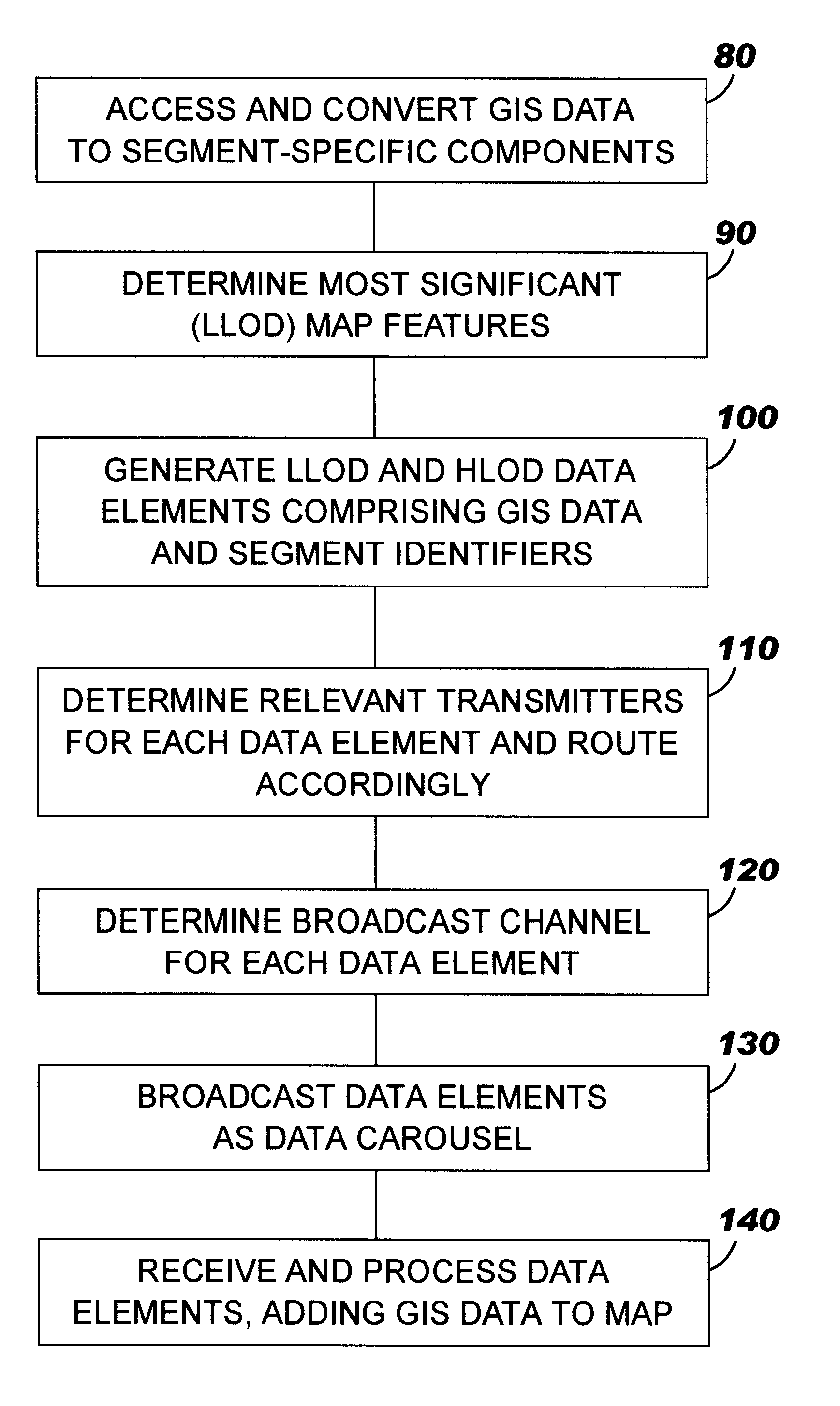
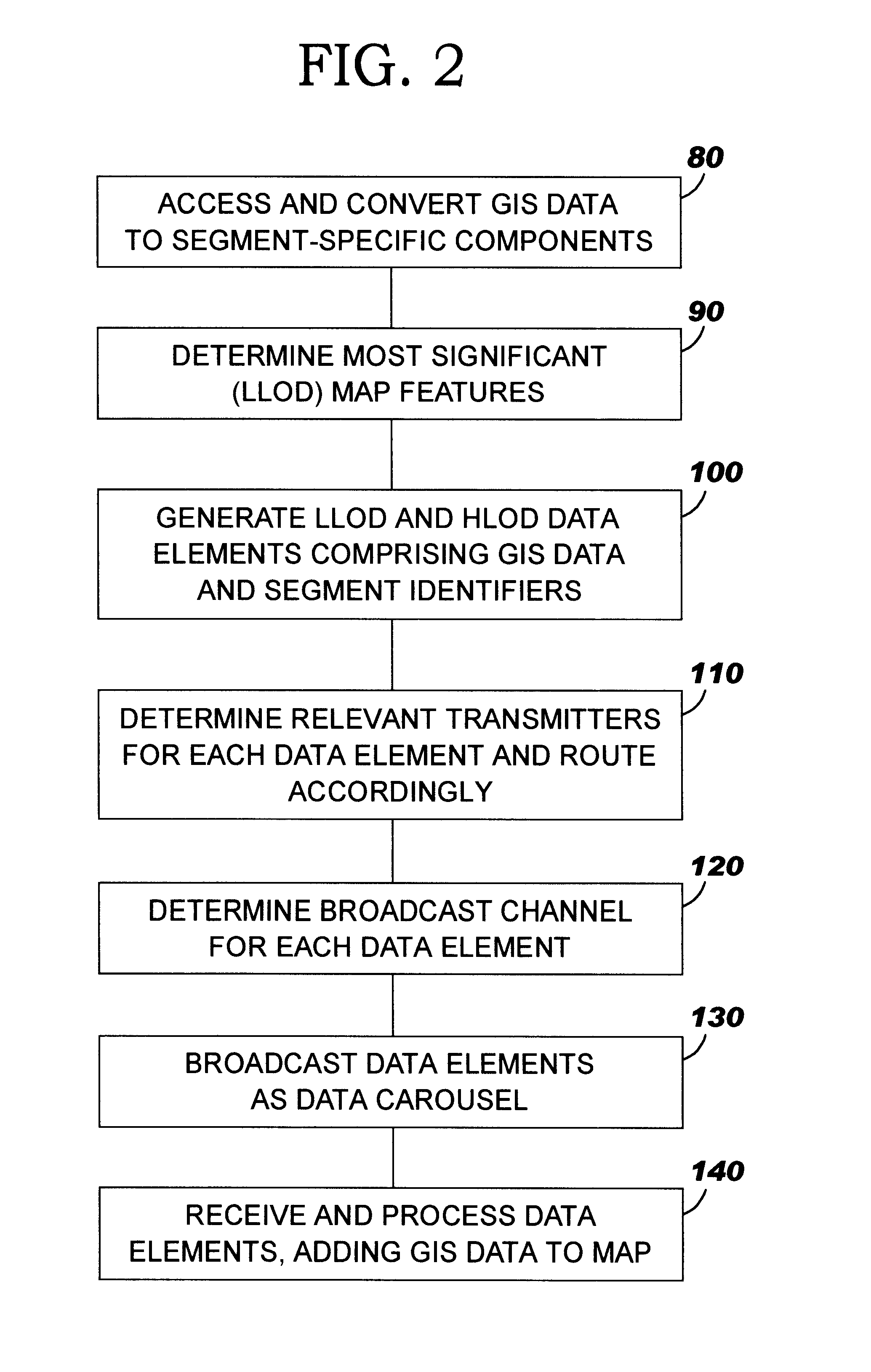
The present invention may be implemented in a public broadcast network, such as a Digital Audio Broadcasting (DAB) network or a standard analogue FM network such as is currently used for broadcasting the Radio Data Services (RDS) information. A DAB network is preferable because of its higher bandwidth. The invention may also be implemented in any other communications network which includes wireless links to mobile devices (hereafter a "wireless communications network").

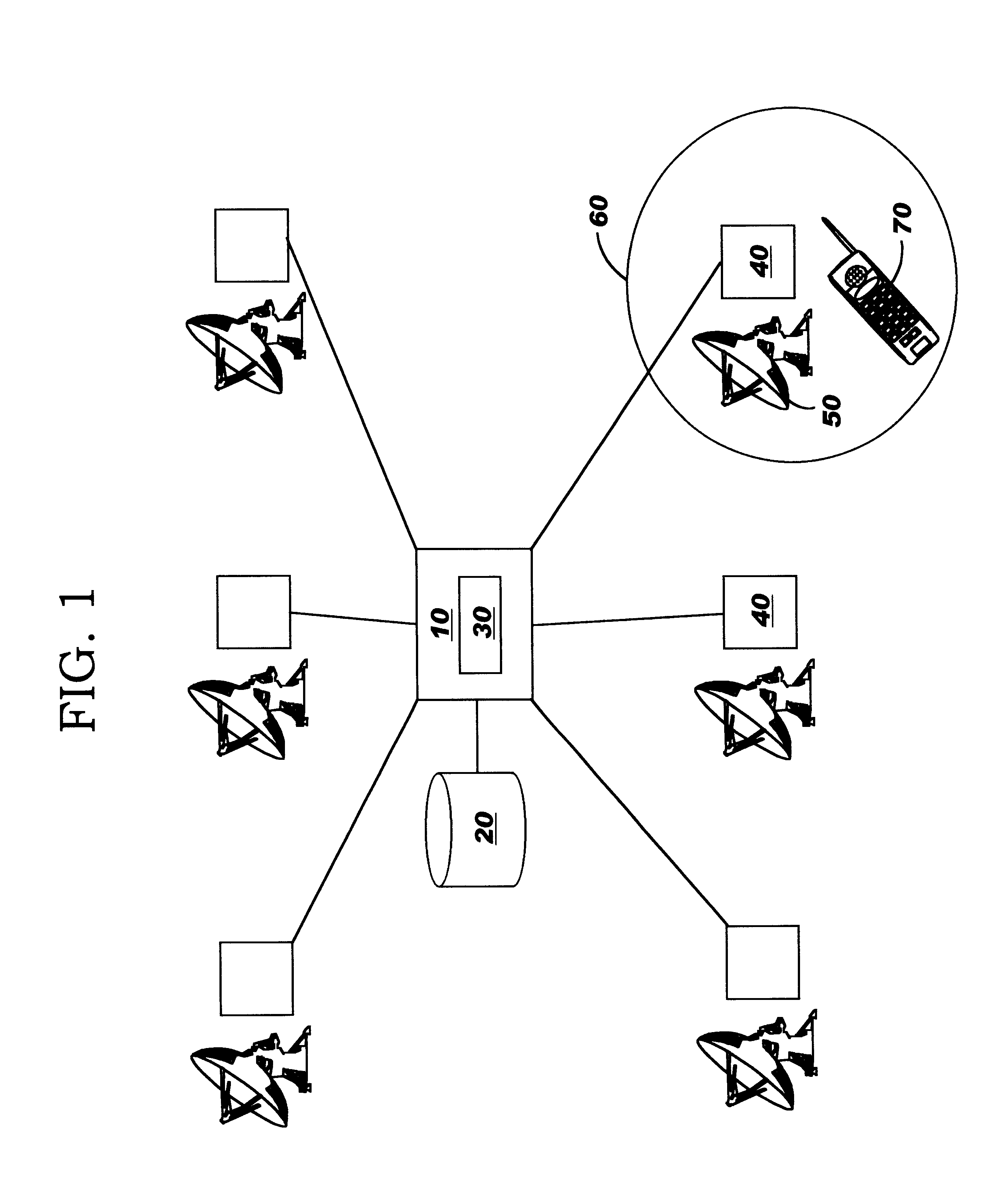
A communications network is shown schematically in FIG. 1, with a central server computer system 10 connected to a number of remote computer systems 40 which are each connected to a transmitter 50. The transmitters 50 broadcast data for receipt by any receiving devices 70 within their respective area of coverage 60. The broadcast network is divided into geographic cells, and these cells overlap to provide overall coverage of a country or region.

The central server computer system 10 is connected to a relational databas...


PUM


Abstract

Provided is a data transmission method, a communications network, a mobile receiving device and data processing methods for use in broadcast of geographic information to mobile devices. The invention overcomes the problem of lack of currency of static information distribution via CD-ROM, and the problem of the cost of lengthy connections to the Internet which is a requirement of some dynamic solutions. The geographic data which is relevant to a transmitter in the network is broadcast by the transmitter as a plurality of separate data elements which each relate to and include an identification of a specific map segment of a segmented map, such that the data elements can be transmitted independently of each other and the map segment identifier can be used by the receiving device to position the geographic information of each data element within the appropriate map segment. Each data element is retransmitted periodically such that gaps can be filled in and the map can be built up over time even if transmission failures occur during a transmission.

Description

The present invention relates to the field of data communications, and in particular to the provision of information to a portable or other mobile device such as a mobile telephone, a lap-top or palm-sized data processing device, a data processing system integrated within a vehicle, or any other mobile receiver device.Currently, solutions for providing information for route planning and associated tourist guides are delivered as static databases to work with an application (e.g. Microsoft AutoMap), usually on a CD-ROM. The main disadvantages of such solutions are that the finite space of the storage medium restricts the scale of the information and, being static, the information is inherently dated. The storage capacity issue is being worked on by Matsushita Communication Industrial Co., Ltd. and others, but this and the lack of currency of information remain significant issues especially for supplementary data such as hotel guides and services information which is associated with a...

Claims


Application Information

Patent Timeline
Patent Type & Authority Patents(United States)
IPC IPC(8): G01C21/34G08G1/0969
CPCG08G1/0969G01C21/26
Inventor SHARP, CHRISTOPHER EDWARDSTANFORD-CLARK, ANDREW JAMES
Owner IBM CORP
Why Eureka
Try Eureka