Method and system of utilizing satellites to transmit traffic congestion information to vehicles

a technology of traffic congestion and satellites, applied in the field of methods and systems for collecting and distributing traffic congestion information, can solve the problems of collecting data, avoiding traffic congestion areas, and expensive installation of stationary sensors at roadside or on the road surface, so as to save the limited bandwidth available, avoid traffic congestion areas, and the effect of reducing the number of times

Inactive Publication Date: 2006-04-11
THE BOEING CO
View PDF8 Cites 54 Cited by
  • Summary
  • Abstract
  • Description
  • Claims
  • Application Information

AI Technical Summary

Benefits of technology

[0011]The traffic information congestion and distribution system provides real-time traffic congestion information to drivers of vehicles equipped with suitable digital radio receivers and navigation systems. The distribution of traffic information is directly to vehicles over digital satellite transponders. An improved traffic information congestion and distribution system comprises an arrangement which provides real-time traffic congestion information data via satellite to drivers of vehicles equipped with a digital radio receiver and navigation system. The traffic information is delivered via digital radio satellites and extracted from automotive digital radio receivers via the data port built into the radio. A data cable will deliver the data to a portable or built-in navigation system, processed and delivered to the driver by synthesized voice and / or visual display for avoiding the areas of traffic congestion.
[0012]The traffic congestion data are collected in a plurality of moving or probe vehicles that travel in traffic and are equipped with tracking devices for data collection. The transmitters can conserve the limited bandwidth available by only transmitting their speed and position information when they encounter a deviation from the expected traffic speed at their location. In a preferred embodiment, most or all of the probe vehicles are motor vehicles which are expected to be routinely traveling the desired roadway route segments while conducting normal business. Each vehicle is equipped with a transmitter for transmitting to a plurality of receiving stations along a roadway of interest. Operation is fully automatic, the tracking device being linked to the ignition system and / or transmission controls or uses other forms of detection, so that it transmits only when the vehicle is being driven. This embodiment involves the lowest possible long term operating costs, because no or only a few probe vehicle communications are required.
[0013]It is an object of the present invention to provide a traffic information congestion and distribution system that effectively assists a driver to avoid traffic congestion.
[0014]It is also an object of the present invention to provide a best-route information that can be computed by a navigation system to offer advice to a driver pertaining to faster route options via visual or audio.

Problems solved by technology

On roadways where a significant proportion of the traffic is attributable to commuters, traffic congestion is a routine problem.
The disadvantage with the current method and system is that installing stationary sensors at roadside or in the road surface is expensive, as is the maintenance of such sensors.
In addition, the obstacle to gathering the data is getting the required licenses from local, state and federal governments to permanent place sensors on or in roadways.
Given the size of a continental highway system using sensors and / or cameras to collect road traffic information data for each and every public road on the continent is impractical.
Previous efforts to provide individualized real time traffic have relied on cell phone technology or terrestrial wireless to transmit the data on onboard modules, and none has integrated this information into intelligent navigation systems, relying instead on the driver's knowledge of local roads and alternate routes.
Moreover, these systems have been limited to specific areas.
Real-time traffic maps are available on desktop computers via Internet, but are not available in a useful form to mobile users.
The bandwidth to transmit maps is too high.
Also, traffic accident reports are available to mobile users, but do not accurately reflect true traffic speeds.

Method used


Image

  • Method and system of utilizing satellites to transmit traffic congestion information to vehicles
  • Method and system of utilizing satellites to transmit traffic congestion information to vehicles
  • Method and system of utilizing satellites to transmit traffic congestion information to vehicles

Examples


Embodiment Construction

[0028]In the following description of the preferred embodiment, reference is made to the accompanying drawings, which form a part hereof, and in which is shown byway of illustration a specific embodiment in which the invention may be practiced. It is to be understood that other embodiments may be utilized and structural changes may be made without departing from the scope of the present invention.

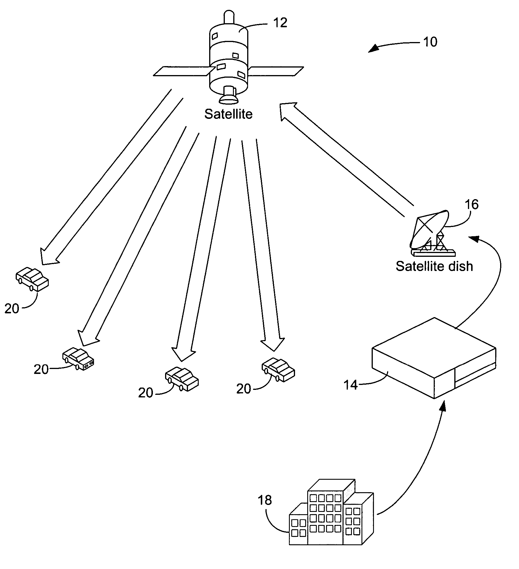
[0029]FIG. 1 illustrates one embodiment of a traffic congestion information distribution system 10 in accordance with the present invention. The traffic distribution system 10 includes at least one digital radio satellite 12, a network operation center and uplink station 14 with a satellite dish 16, a central traffic information station 18, and a group of traffic information user vehicles or mobile users 20 which travel segments of a road network which may be a metropolitan highway system, a regional highway system, national expressway system or a cross-continent expressway system. The sate...


PUM


Abstract

A method and system for collecting and distributing vehicle traffic congestion information is disclosed. The method and system optionally involves deploying probe vehicles or other data sources for collecting and transmitting detailed traffic information which describes vehicle speeds actually being experienced along the routes of interest and transmitting all this information into a central computer at a central traffic data station, where the data are processed.

Description

BACKGROUND OF THE INVENTION[0001]1. Field of the Invention[0002]The present invention relates generally to methods and systems for collecting and distributing traffic congestion information, and in particular to a method and system for distributing formed traffic congestion information about those conditions to a traffic information user and / or forming traffic congestion data based on collected traffic information of a current position and speed.[0003]2. Description of the Related Art[0004]On roadways where a significant proportion of the traffic is attributable to commuters, traffic congestion is a routine problem. In some particularly crowded areas, such as metropolitan areas of the country, traffic during commuter hours slows to a stop. Various methods and systems are known for the metrological collection of data for traffic assessment in segments of a road network Several systems for monitoring traffic and informing motorists of traffic conditions have been used. In some cities,...

Claims


Application Information

Patent Timeline
Patent Type & Authority Patents(United States)
IPC IPC(8): G08G1/123G08G1/00G08G1/01
CPCG08G1/202G08G1/0104
Inventor WAINFAN, S. LYNNELIM, SAMUELRILEY, RICHARD T.
Owner THE BOEING CO
Why Eureka
Try Eureka