

Semi-automatic reconstruction method of 3-D building models using building outline segments
a reconstruction method and building technology, applied in the field of semi-automatic reconstruction methods, can solve the problems of excessive manual editing, laborious whole procedure, time-consuming and costly, etc., and achieve the effect of reducing operator's workload, reducing production costs, and simplifying the job of the operator
- Summary
- Abstract
- Description
- Claims
- Application Information
AI Technical Summary
Benefits of technology
Problems solved by technology
Method used
Image

Examples
embodiment 1
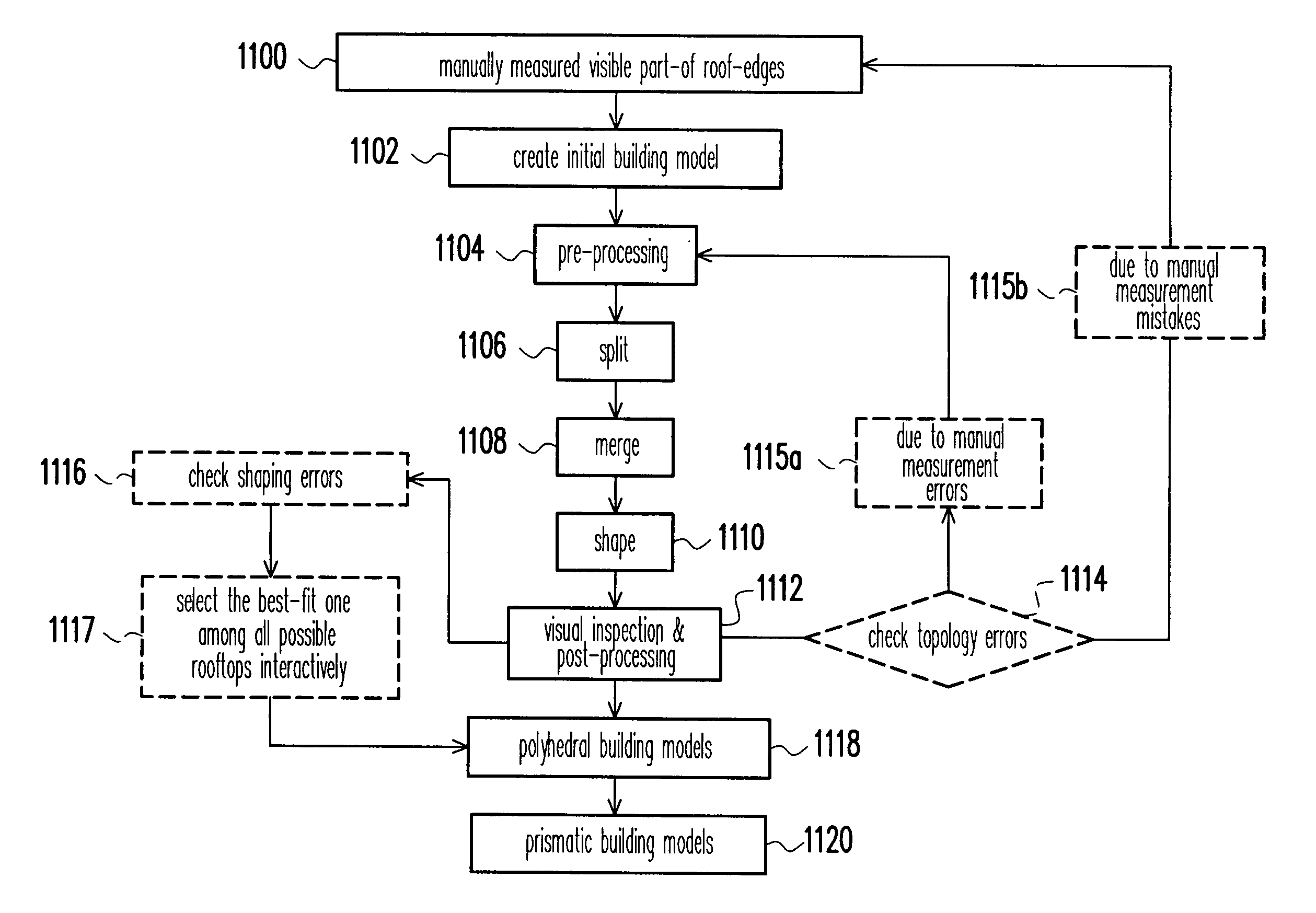
[0060]FIG. 8 shows a group of connected buildings with varied and complex structure, including a circular-flat-roof “800”, two courtyards “802”, and some gable-hip-roofs “804”. In a model-based approach of building model reconstruction, this situation may cause failure or difficulty.
[0061]The aerial stereo-images in FIG. 9 are taken from two different view positions. Certain building corners are observable in one image (such as those in the circled areas on the right-view image in FIG. 9), but may be occluded when another image was taken from a different view position (comparing to those on the left-view image in FIG. 9). In manually stereo-measurements, those hidden corners have to be manually estimated or edited. Such a process will increase the workload especially for densely built-up areas. Additionally, due to manually stereo-measurement errors, it will cause topologic errors at neighboring buildings and excess manual editing is necessary. In the present invention, by ignoring ...
embodiment 2
[0078]For a fully performance study about the present invention, a building outline segment data set was measured manually using a digital photogrammetric workstation. The scale of the original aerial stereo-images was 1:5,000 with a 60% overlap. The focal length of the camera was 30.511 cm, and the base-height ratio was approximately 0.3. Digital images were digitized with a scanning resolution of 25 μm. The produced images have a nominal ground sampling distance of 12.5 cm. The content of this test data set can be abstractly categorized into three parts.[0079]a) Part (I) is a university campus. The buildings are large with complex boundary, and are separated to each other with a distance.[0080]b) Part (II) is a high-density built-up area with groups of connected and rectangular structured buildings.[0081]c) Part (III) is a high-density built-up area with groups of connected, complex rooftops, and less-orthogonal buildings
[0082]FIG. 16 depicts the above three areas on one of the or...
PUM
 Abstract
Description
Claims
Application Information