
Method and apparatus for locating position of a mobile receiver

a mobile receiver and position technology, applied in wave based measurement systems, instruments, navigation instruments, etc., can solve the problem of limited effectiveness of such averaging

Active Publication Date: 2007-01-02
AVAGO TECH INT SALES PTE LTD
View PDF5 Cites 15 Cited by
  • Summary
  • Abstract
  • Description
  • Claims
  • Application Information

AI Technical Summary

Benefits of technology

The patent describes a method and device for locating the position of a mobile device using satellite measurements. The device can determine the position by measuring the distance between the device and the satellites or by monitoring information received from the satellites. The device can also compare the changes in the information over time to a threshold to determine if it is stationary. The position is then computed based on the sets of satellite measurements and a navigation model. The technical effect of this patent is to provide a more accurate and reliable way to locate the position of a mobile device.

Problems solved by technology

However, effectiveness of such averaging is limited if the GPS receiver is in motion.

Method used


Image

  • Method and apparatus for locating position of a mobile receiver
  • Method and apparatus for locating position of a mobile receiver
  • Method and apparatus for locating position of a mobile receiver

Examples


Embodiment Construction

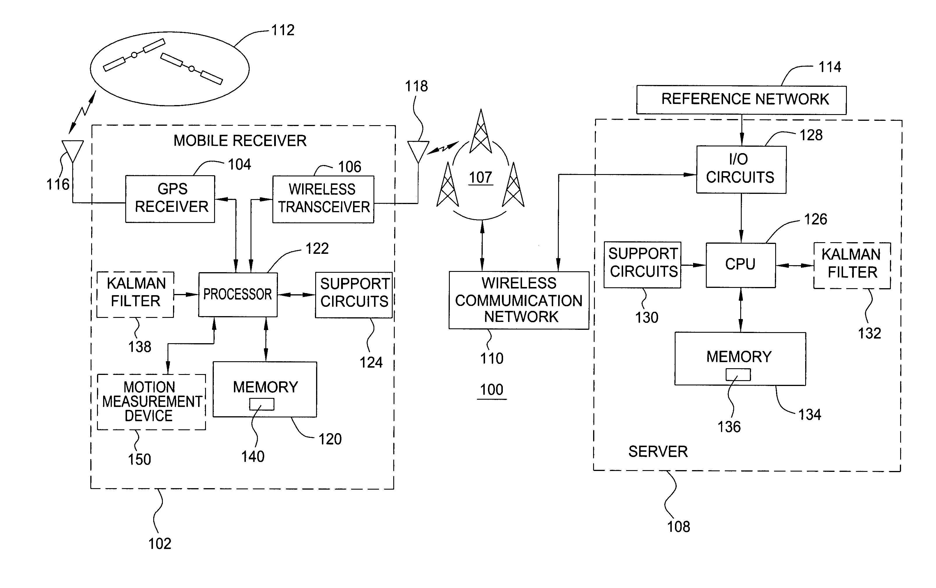
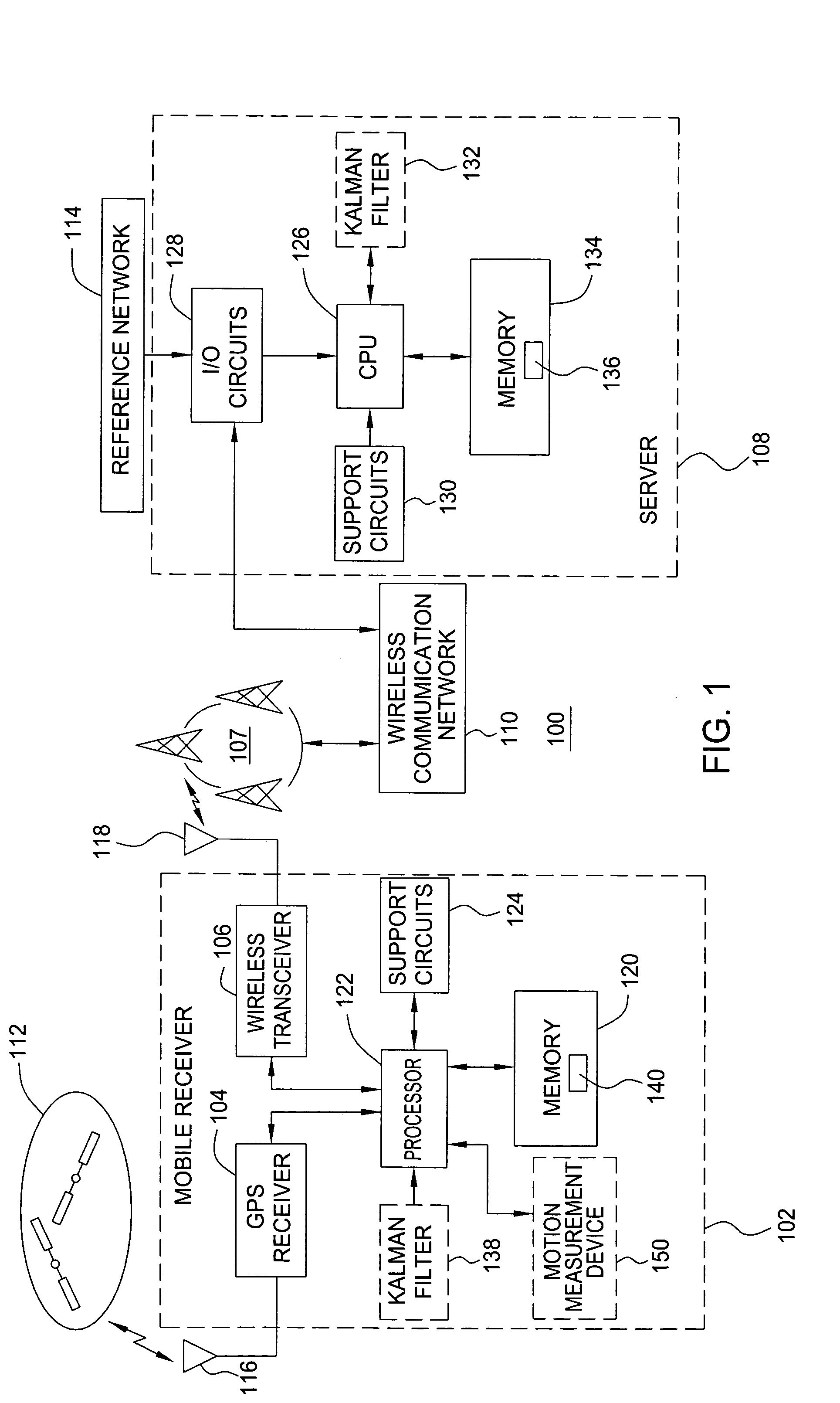
[0015]FIG. 1 is a block diagram depicting an exemplary embodiment of a position location system 100. The system 100 comprises a mobile receiver 102 in communication with a server 108 via a wireless communication network 110. For example, the server 108 may be disposed in a serving mobile location center (SMLC) of the wireless communication network 110. The mobile receiver 102 obtains satellite measurement data with respect to a plurality of satellites 112 (e.g., pseudoranges, Doppler measurements). The server 108 obtains satellite navigation data for at least the satellites in view (e.g., orbit trajectory information, such as ephemeris, for the satellites 112). Position information for the mobile receiver 102 is computed using the satellite measurement data and the satellite navigation data.

[0016]In one embodiment, the mobile receiver 102 sends the satellite measurement data to the server 108, and the server 108 locates position of the mobile receiver 102 (referred to as the mobile ...


PUM


Abstract

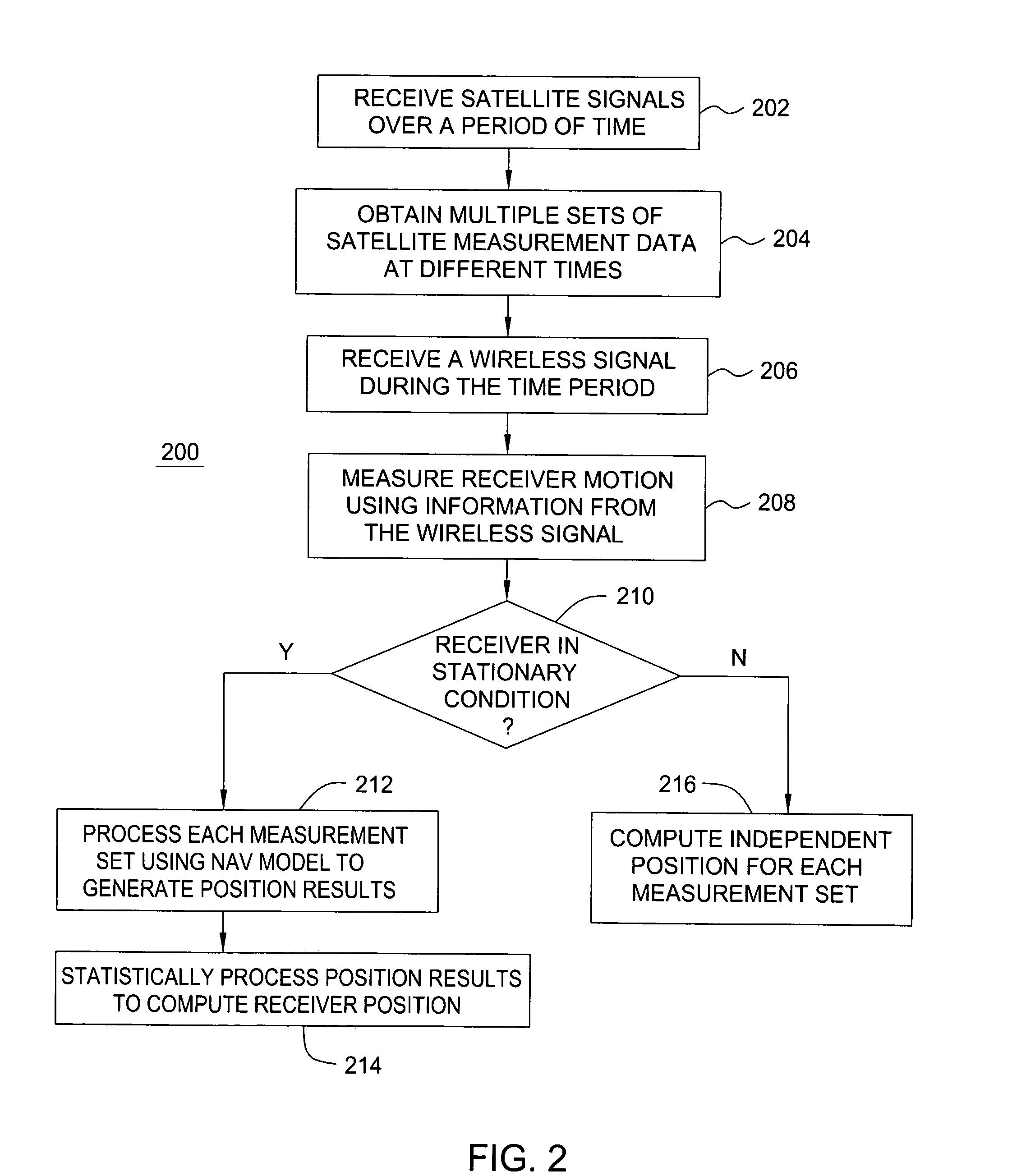
A method and apparatus for locating position of a mobile receiver is described. In one example, sets of satellite measurements are determined with respect to a plurality of satellites over a period of time. A determination is made as to whether the mobile receiver is in a stationary condition over the period of time. A position of the mobile receiver is then computed using the sets of satellite measurements in response to detection of the stationary condition.

Description

BACKGROUND OF THE INVENTION[0001]1. Field of the Invention[0002]The present invention generally relates to satellite positioning systems and, more particularly, to locating position of a mobile receiver.[0003]2. Description of the Related Art[0004]Global Positioning System (GPS) receivers use measurements from several satellites to compute position. GPS receivers normally determine their position by computing time delays between transmission and reception of signals transmitted from satellites and received by the receiver on or near the surface of the earth. The time delays multiplied by the speed of light provide the distance from the receiver to each of the satellites that are in view of the receiver.[0005]More specifically, each GPS signal available for commercial use utilizes a direct sequence spreading signal defined by a unique pseudo-random noise (PN) code (referred to as the coarse acquisition (C / A) code) having a 1.023 MHz spread rate. Each PN code bi-phase modulates a 1575...

Claims


Application Information

Patent Timeline
Patent Type & Authority Patents(United States)
IPC IPC(8): G01C21/26G01S1/00G01S5/14G01S19/09G01S19/46
CPCG01S19/258
Inventor ABRAHAM, CHARLESVAN DIGGELEN, FRANK
Owner AVAGO TECH INT SALES PTE LTD
Learn More