Hi-accuracy three-dimensional topographic modeling apparatus

a topographic modeling and accurate technology, applied in the field of creating in hi-accuracy three-dimensional geographically realistic topographic models, can solve the problems of time-consuming cutting-path repetitions, inability to accurately scale the topographic model, and the algorithmic interpolation of less efficient computer-controlled multi-axis systems that might otherwise execute a slower algorithm, etc., to achieve accurate scaled terrain models, accurate and accurate indicia cutting, and the effect of increasing the speed of terrain model making

Inactive Publication Date: 2007-05-08
SOLID TERRAIN MODELING
View PDF19 Cites 31 Cited by
  • Summary
  • Abstract
  • Description
  • Claims
  • Application Information

AI Technical Summary

Benefits of technology

[0012]In accordance with the present invention, methods are defined for an apparatus having computer and efficient algorithmic control of one or more rotation cutting means to: (1) cut a series of parallel paths and remove unwanted cross-sections of modeling material above the lowest perimeter edge of each of such cross-sections so as to render accurately scaled terrain models, and (2) cut durable and accurately registered and scaled indicia of a prescribed depth into the surface of any of a variety of types of topographical and other models.
[0013]Another aspect of the present invention is to provide an automated system for achieving the above-mentioned methods. The system includes a hi-accuracy three-dimensional cutting apparatus for topographic modeling that is electronically coupled with a computer. The computer has a central processor that executes instructions, a memory for storing instructions to be executed, and non-volatile storage for storing the messages. The executable computer instructions of the system include one or more algorithms for converting the complex and randomly-occurring contours found in natural terrains into an efficient series of modeling material removal swaths defined in simplified 2-axis cross-sections that are cut adjacent

Problems solved by technology

By contrast, a less efficient computer-controlled multi-axis system might otherwise execute a slower algorithmic interpolation which attempts to define cutting paths of the randomly shaped elevational contours such as the type found on topographical maps.
However, such an approa

Method used


Image

  • Hi-accuracy three-dimensional topographic modeling apparatus
  • Hi-accuracy three-dimensional topographic modeling apparatus
  • Hi-accuracy three-dimensional topographic modeling apparatus

Examples


Embodiment Construction

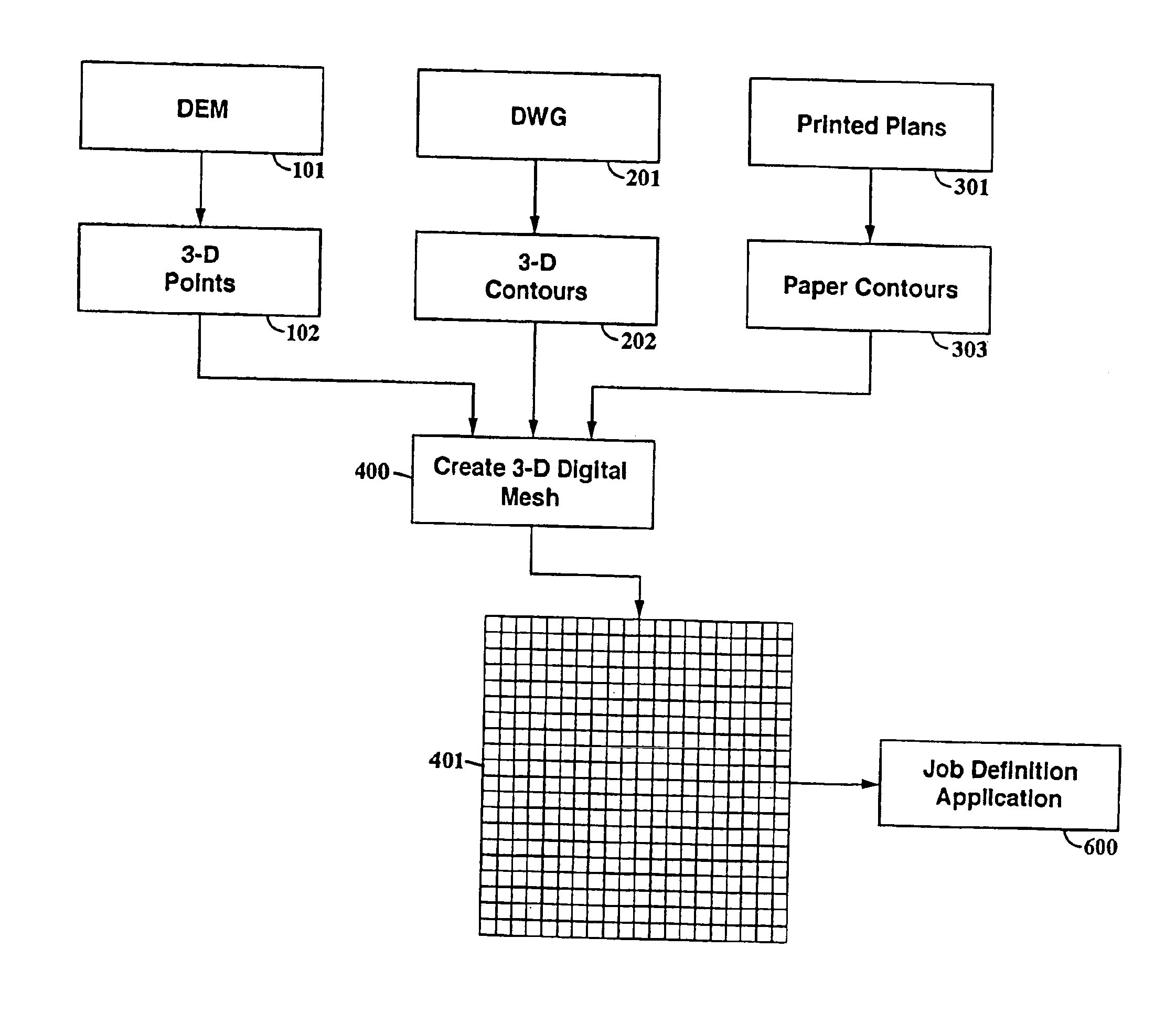
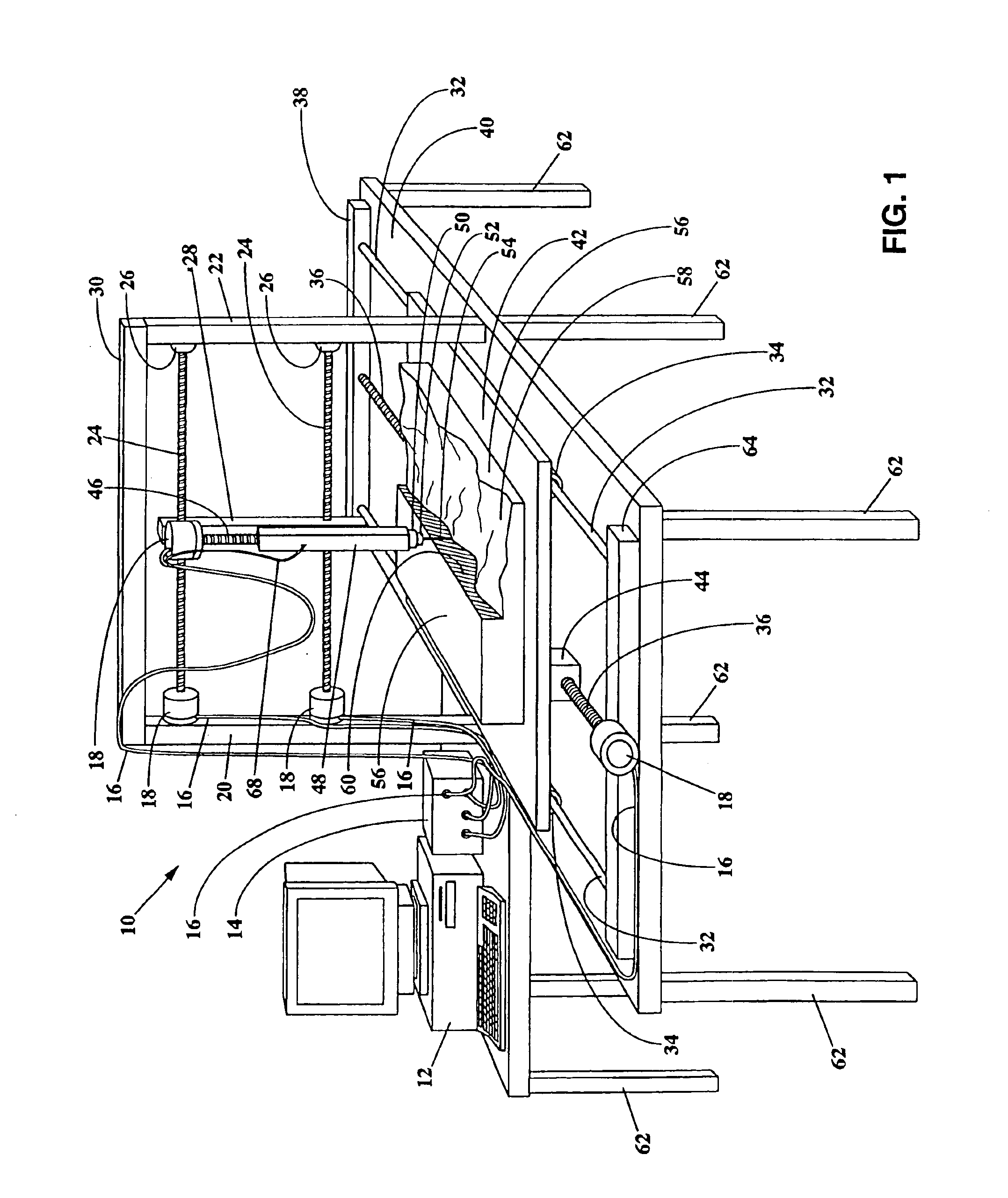
[0030]With reference to FIG. 1, a hi-accuracy 3D topographic modeling apparatus 10 is shown adjacent to and electronically coupled with a computer system 12. The computer has a central processor that executes instructions, a memory for storing instructions to be executed, and non-volatile storage for storing the messages. Also included is a control interface 14 having electronic coupling 16 to control a plurality of stepper motors 18. It is noted that, although interface 14 is shown in a housing which is external to the computer and separate from the stepper motors, one or more of the apparatus-controlling components housed therein could instead be located within the housing of the computer (e.g., on a circuit board interfaced with the CPU of the computer), and / or could be located within, or adjacent to, one or more stepper motor housing. Adjacent to computer 12 and interface 14 is a Y-axis support bed 40 that is supported by a legs 62. The upper surface of bed 40 supports rear end-...


PUM

PropertyMeasurementUnit
Diameteraaaaaaaaaa
Sizeaaaaaaaaaa
Densityaaaaaaaaaa

Abstract

A cutting apparatus includes a hi-accuracy three-dimensional cutting apparatus for topographic modeling that is electronically coupled with a computer. The computer has a central processor that executes instructions, a memory for storing instructions to be executed, and non-volatile storage for storing the messages. The executable computer instructions of the system include one or more algorithms for converting the complex and randomly-occurring contours found in natural terrain into an efficient series of modeling material removal swaths defined in simplified 2-axis cross-sections that are cut adjacent and parallel to one another. The swaths are defined in a simplified 2-axis surface contour-following rotation cutting device moved by the system's CPU, driver software, driver circuitry and/or logic circuitry. This multi-axis control of the system assures that each of the swaths are seamlessly rendered next to one another while also maintaining an optimal proximity between the upper surface of the 3D model and the rotation cutting device.

Description

BACKGROUND OF THE INVENTION[0001]This application claims the benefit of U.S. Provisional Patent Application Ser. No. 60 / 195,130 filed on Apr. 6, 2000, the entire disclosures of which are incorporated herein by reference.FIELD OF THE INVENTION[0002]The present invention generally relates to apparatus, methods and systems for creating in hi-accuracy three-dimensional geographically realistic topographic models, and more specifically, it pertains to apparatus for improving the accuracy of three dimensional (3D) terrain modeling generally, or for making such models quickly when needed in emergency situations, or for adding accurately and durably registered indicia to any in a variety of types of topographical models.DESCRIPTION OF RELATED ARTS[0003]Numerous attempts have been made to provide methods for modeling places or regions. However the techniques used to render the surface features of a place or region on a 3D terrain map, and indicating their relative positions and elevations, h...

Claims


Application Information

Patent Timeline
IPC IPC(8): G05B11/01B44C3/12G06F19/00G05B19/4099G09B25/06
CPCG05B19/4099G09B25/06G05B2219/49002G05B2219/49013G05B2219/49014Y10T409/300896Y10T409/301792Y10T409/307728Y10T409/307784G05B11/01
Inventor FAULKNER, LAWRENCE Q.FISHER, MARK E.LUTON, JUSTIN
Owner SOLID TERRAIN MODELING
Why Eureka
Try Eureka