Real-time navigation system for mobile environment

a real-time navigation and mobile environment technology, applied in traffic control systems, navigation instruments, instruments, etc., can solve the problems of not providing real-time directions, user confusion or update directions, and requiring special equipment in the vehicle, so as to facilitate and efficiently provide navigational directions

Inactive Publication Date: 2008-06-17
TELENAV INC
View PDF57 Cites 143 Cited by
  • Summary
  • Abstract
  • Description
  • Claims
  • Application Information

AI Technical Summary

Benefits of technology

[0016]This invention is generally directed to method and system for providing navigational directions to a user. The user is connected to the system through a real-time connection, such as a wireless telephone, PDA, or other device. Generally, the system uses the capabilities of a central processor to conveniently and efficiently provide navigational directions to a user in real-time.

Problems solved by technology

Such systems, however, do not provide real-time directions; once the user is on the road, the user cannot receive clarification or updates to the directions.
These systems, however, generally require specialized equipment in the vehicle, such as specialized input / output apparatus, graphical displays, a map database, or processor.
Such equipment is expensive and cumbersome for the user, especially in those situations where the user is walking, changing vehicles, or otherwise away from the vehicle in which the equipment is installed.
There are several technical obstacles that stand in the way of the incorporation of navigational capabilities in handheld devices for providing turn-by-turn real-time navigation services.
One such obstacle is the amount of geographic data needed to provide reasonably detailed navigational information.
The amount of embedded memory in such devices is limited and thus they are not suited for storage of large amounts of geographic information.
Another obstacle is the lack of information processing power in small devices, such as those mentioned above.
While the information processing power of embedded microprocessors is generally increasing, such processors are still not suitable for processor intensive real-time navigational tasks.
An additional obstacle is the insufficient location accuracy provided by current technology.
Initial sources of inaccuracy of the GPS based systems, for example, may, be imposed by the U.S. Department of Defense through Selective Availability (S / A), while other sources of error are due to atmospheric and timing errors limiting the accuracy of a single GPS receiver to + / −50 meters.
However, such radio beacons are not available to consumers traveling in most inland locations.
Navigational systems are difficult to develop further because the desired accuracy depends on the particular application.
For example, if the user is driving in a downtown area with closely spaced streets, a GPS location with accuracy within, for instance, + / −50 meters is not adequate to give turn-by-turn directions.
In this context, GPS location information is thus considered ambiguous and inappropriate for practical navigation.
However, for a navigational system implemented using handheld devices, such as cellular telephones, it is undesirable to require the handheld device to be connected to external sensors, especially when the device is used while walking.
Other obstacles confront navigational systems designed for use when walking.
Such systems are generally limited by the user's communication device.
For instance, it is difficult for a user to enter detailed information over a wireless telephone in a format that is useful for the central processor, especially if the user is engaged in other activities such as driving a vehicle.
These systems are also susceptible to imperfections of the underlying service; for instance, establishing or maintaining a connection over the wireless network(s) can be difficult.
Also, the rate of transfer of information over wireless networks can be extremely limiting.

Method used


Image

  • Real-time navigation system for mobile environment
  • Real-time navigation system for mobile environment
  • Real-time navigation system for mobile environment

Examples


Embodiment Construction

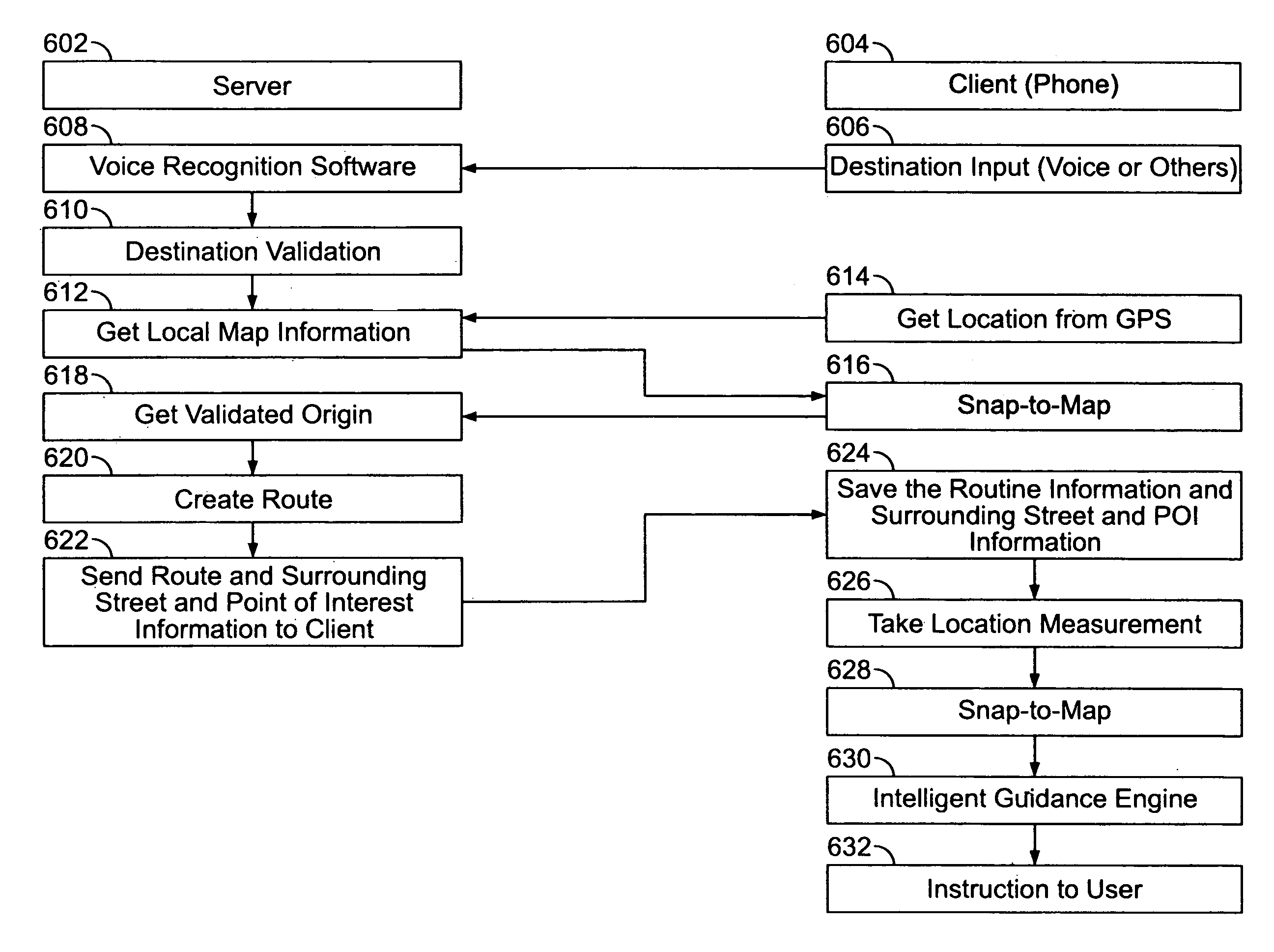
[0034]The present invention is directed to a method and apparatus for providing navigational information to a user connected to the system through a real-time connection, such as a wireless network.

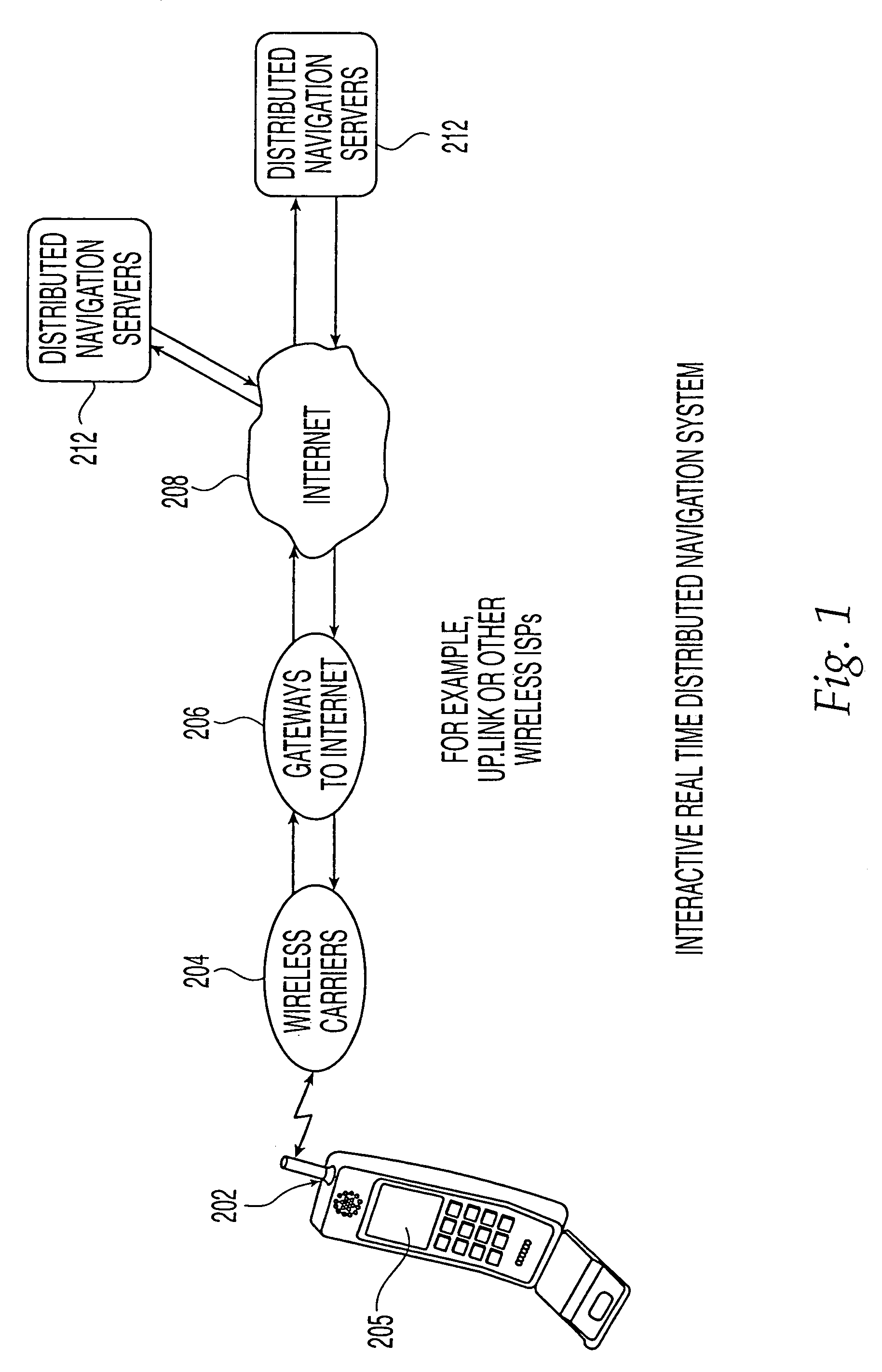
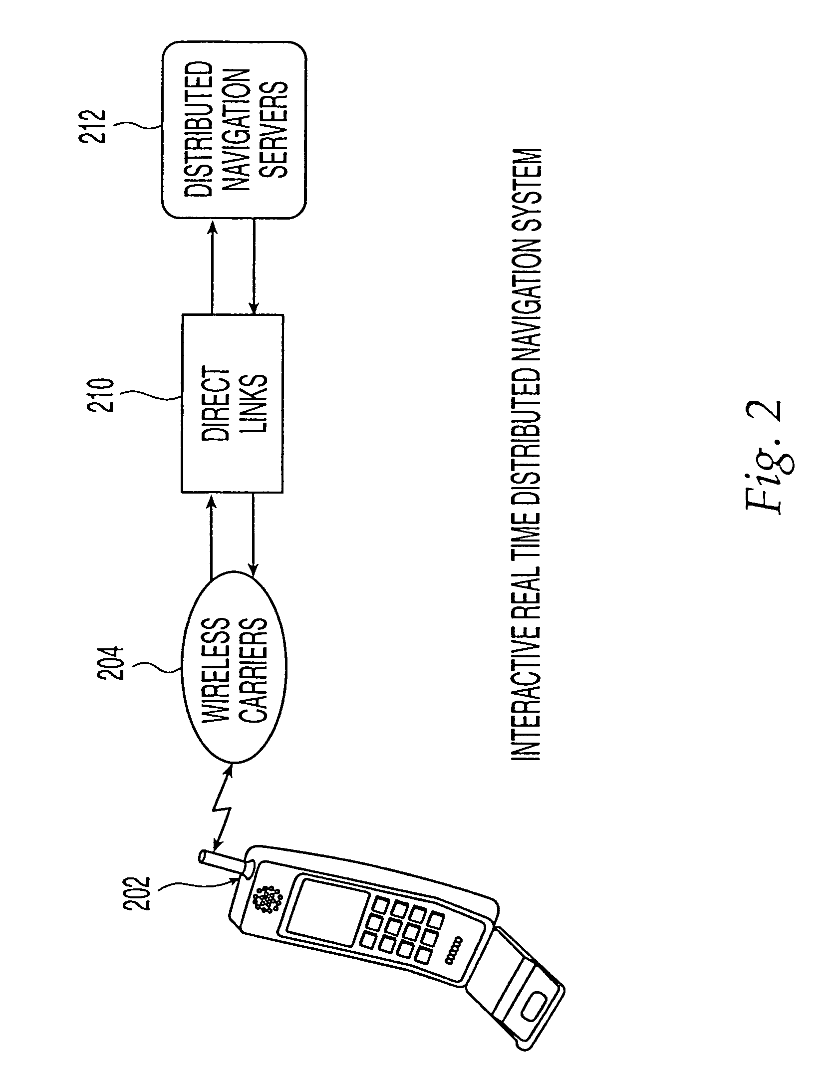
[0035]FIG. 1 shows an architecture for an interactive real-time distributed navigation system in accordance with a preferred embodiment. The various components and their interaction will now be described. It is to be understood that where like numerals are used in different figures, such like numerals refer to the same item. Wireless device 202 may take the form of a cellular telephone, satellite telephone, wireless Personal Digital Assistant (PDA), personal computer or other suitable device having wireless communications capability. Preferably, wireless device 202 is equipped with positioning capability that takes the form of, for example, global positioning systems (GPS), emergency 911 (E911) location, or others, including those that may become available in the future. Currently, variou...


PUM


Abstract

A system and method for providing navigational information to a user connected in real-time, such as through a wireless telephone, PDA, or other device. The system provides navigational information to the user in the form most useful to the user, such as according to landmarks, or the number of blocks until the next action. The system also provides directions to points of interest along the user's route. Further, the system allows the user to suspend and resume a session. Also, the system varies the sampling rate at which the user's location is examined, to enhance efficiency and convenience.

Description

[0001]This application is a Continuation of application Ser. No. 10 / 057,236 filed on Jan. 24, 2002 now abandoned, which claims benefit of Provisional Application 60 / 264,164, filed Jan. 24, 2001.FIELD OF THE INVENTION[0002]This invention relates to navigation systems and location-based information delivery. Specifically, this invention relates to a method and system for an efficient operating environment for interactive and real-time navigation.BACKGROUND OF THE INVENTION[0003]The present invention relates to a system for providing navigational information to a user. The increasing use of portable appliances, such as wireless telephones and personal digital assistants (PDAs), has led to widespread use of such devices during travel. If and when such travelers become lost or otherwise need navigational directions, it would be very convenient and useful to receive such directions through their wireless devices.[0004]A number of navigational systems are available or under development. Sy...

Claims


Application Information

Patent Timeline
Patent Type & Authority Patents(United States)
IPC IPC(8): G01C21/26G01C21/20H04W4/20G08G1/0968H04W4/02H04W4/024H04W4/029
CPCG01C21/20G01C21/00G01C21/34G01C21/3626G01C21/3679G06Q10/047G08G1/096811G08G1/096838G08G1/096844G08G1/096861G08G1/096872G08G1/096883H04W4/02H04W4/20G01C21/26G01C21/36G08G1/0968H04W4/024H04W4/029
Inventor JIN, HAIPINGMESHENBERG, RUSLAN ADIKOVICDHANANI, SALMANGLEBOV, ALEXANDER G.
Owner TELENAV INC
Why Eureka
Try Eureka