System and method for GPS acquisition using advanced tight coupling

a technology of tight coupling and gps acquisition, applied in direction finders, navigation instruments, instruments, etc., can solve the problems of large noise suppression, uncorrelated noise between satellites with equal variance, and acquisition in the presence of jamming, etc., to achieve easy integration into existing navigation filter designs and high noise environment

Active Publication Date: 2008-08-19
L3 TECH INC
View PDF17 Cites 31 Cited by
  • Summary
  • Abstract
  • Description
  • Claims
  • Application Information

AI Technical Summary

Benefits of technology

[0017]These and other problems are solved by an Advanced Tightly Coupled (ATC) multi-satellite tracking system for acquisition and tracking in a high noise environment. Nonlinear transformations of I and Q tracker measurements are developed to yield linear measurements of pseudorange and carrier phase errors corrupted by white, additive, and unbiased noise. The system's design parameters are provided by application of linear estimation theory, allowing it to be easily integrated into existing navigation filter designs.
[0018]In one embodiment, parallel time search during satellite acquisition is provided by allocating plurality of channels to each satellite being acquired. The various taps of each channel are distributed in time such that the plurality of channels work in parallel to provide relatively simultaneous search over more chips than can be searched by each channel working alone. In one embodiment, all available channels (and all taps) are configured to search for a single satellite. The taps are distributed according to a desired chip spacing centered at the expected range. In one embodiment, a first half of the available channels are configured to search for a first satellite and a second half of the available channels are configured to search for a second satellite. In one embodiment, a first group of the available channels are configured to search for a first satellite, a second group of the available channels are configured to search for a second satellite, a third group of the available channels are configured to search for a third satellite, etc. Once the desired satellites have been acquired, then the GPS system tracks the satellites. Range residuals from the advanced tight coupling filters are used to improve the acquisition process.
[0029]The constant, linear state transition and the linear, and approximately constant measurement relations, allow the phase error estimator to handle relatively large magnitude swings in the measurements in the presence of relatively high noise. It is the ability to estimate the statistics of the noise that allows the parameters in the phase error estimator to be adjusted properly.
[0032]When the interference noise is low, the I and Q amplitude measurement is projected back through the system gain to estimate the constant satellite signal amplitude. Then, when the noise increases, the satellite signal amplitude estimate is projected forward through the system gain to estimate the I and Q amplitude. This process produces an approximately nonrandom multiplier for the range and range rate residual error measurements during periods of high signal interference. This helps the phase error estimator perform properly in a relatively high noise environment.

Problems solved by technology

A major tracking loop design tradeoff is the ability to handle high vehicle dynamics and to also track through high interfering noise.
Lowering the bandwidth results in greater noise suppression.
While the systems described above can track through substantial jamming, the problem of acquisition in the presence of jamming remains.
However, each satellite's code is a pseudo random sequence, which when correlated with the input noise, produces uncorrelated noise between the satellites with equal variance.

Method used


Image

  • System and method for GPS acquisition using advanced tight coupling
  • System and method for GPS acquisition using advanced tight coupling
  • System and method for GPS acquisition using advanced tight coupling

Examples


Embodiment Construction

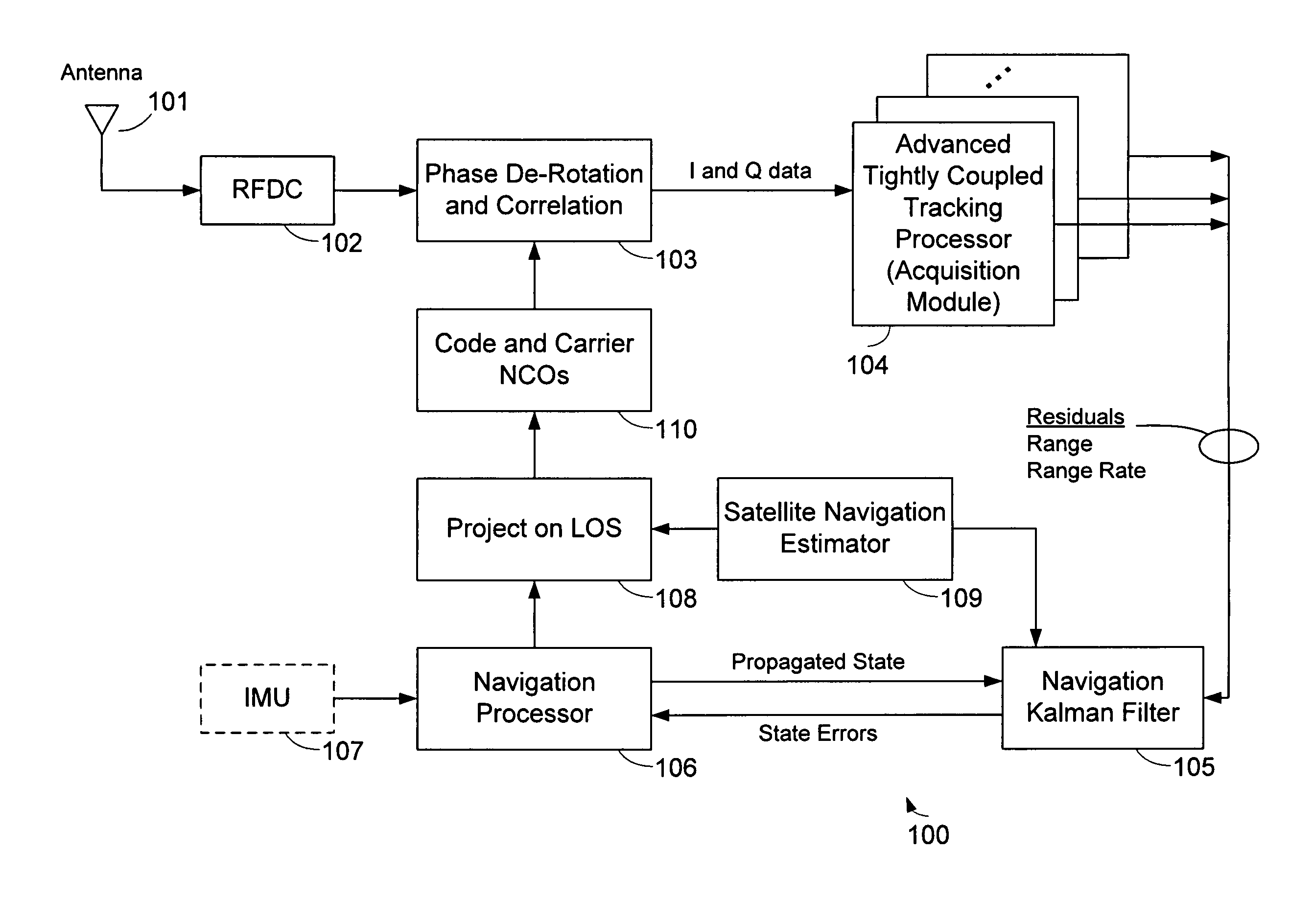
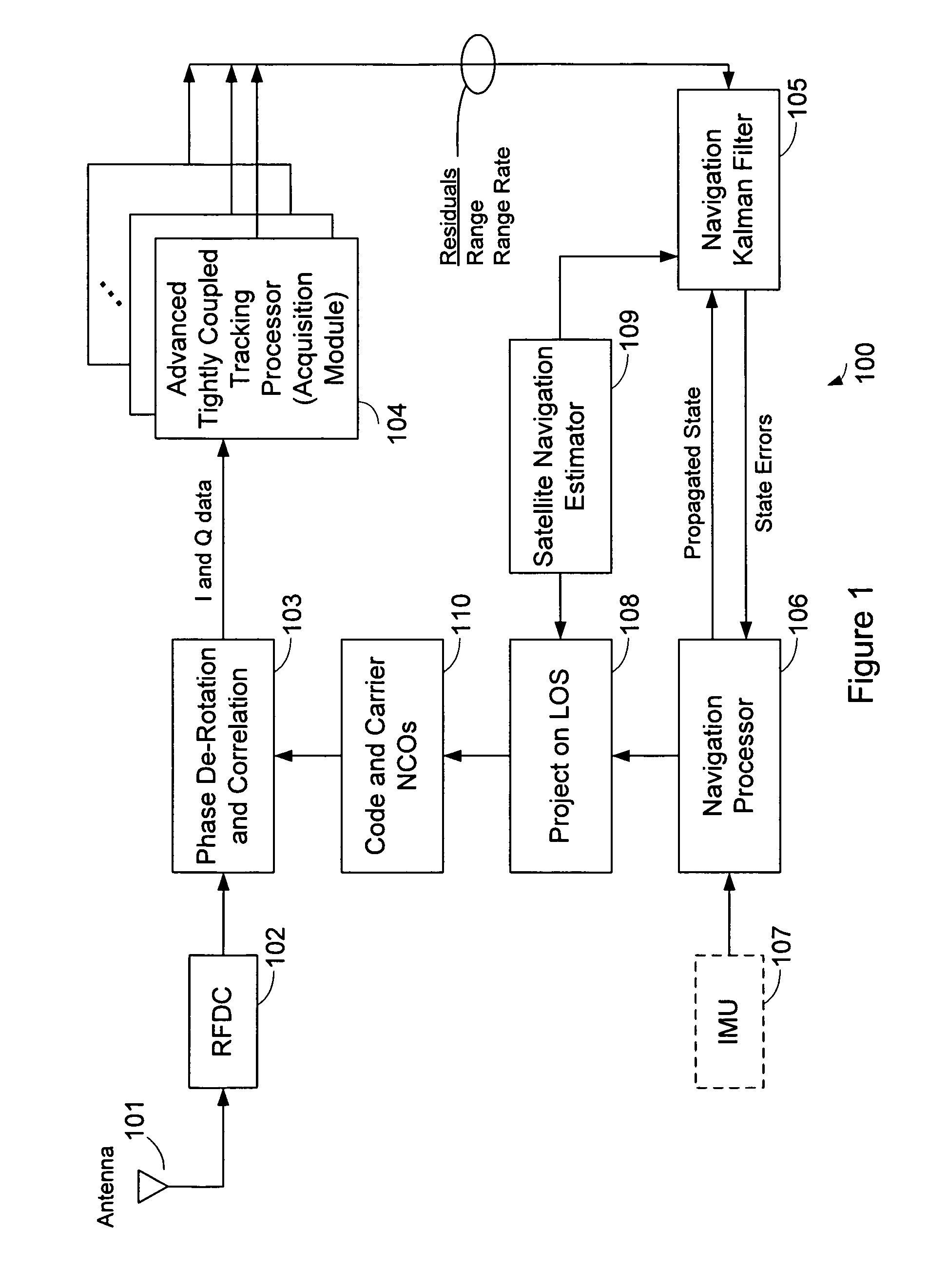
[0038]FIG. 1 is a block diagram showing multi-satellite tracking system 100. In the system 100, satellite navigation signals are received by an antenna 101 and provided to a Radio Frequency Down Converter (RFDC) 102. Downconverted signals from the RFDC 102 are provided to a phase de-rotation and correlation block 103. De-rotated and correlated signals from block 103 are provided to an ATC tracking processor 104. In one embodiment, the ATC tracking processor 104 is configured as a multi-channel processor to allow simultaneous tracking of multiple satellites. The ATC tracking processor 104 provides residuals of range, range rate and range acceleration to a 24-state navigation Kalman filter 105. Navigation state errors from the Kalman filter 105 are provided to a navigation processor block 106. In one embodiment, inertial measurements from an optional IMU 107 are provided to the navigation processor block 106 and the inertial measurements are used by the navigation processor 106 to aid...


PUM


Abstract

A system and method for GPS acquisition in relatively high interference is described. Acquisition is aided by an Advanced Tightly Coupled (ATC) tracking filters that compute a satellite range residuals and range rate residuals for satellites being acquired. Multiple channels are used in parallel to search for the desired satellites. Range residuals from the ATC filters are used to correct the computed receiver offset and thus allow acquisition in the presence of relatively high interference.

Description

BACKGROUND OF THE INVENTION[0001]1. Field of the Invention[0002]The invention relates to a new method of combining GPS and navigation estimates to provide GPS acquisition in the presence of interfering signals.[0003]2. Description of the Related Art[0004]The Global Positioning System has revolutionized navigation. Prior to the twentieth century, land and sea navigation was performed using angle measurements to celestial bodies, magnetic compass measurements, and time measurements from an accurate clock to determine longitude. At the beginning of the twentieth century, the first airplane flight foreshadowed the need for more accurate navigation systems. Radio and inertial navigation systems soon supplanted the old methods.[0005]The GPS concept was developed in the early 1970s as a joint military service project and the first satellite was launched in 1978. GPS satellites transmit time synchronized signals in the L frequency band (approximately 1.5 GHz) using atomic clocks. The signal...

Claims


Application Information

Patent Timeline
Patent Type & Authority Patents(United States)
IPC IPC(8): G01S1/00G01S19/26G01S19/47
CPCG01S19/47G01S19/53G01S19/52
Inventor ALEXANDER, STEVEN B.
Owner L3 TECH INC
Why Eureka
Try Eureka