System and method for advanced tight coupling of GPS and inertial navigation sensors

a technology of inertial navigation and advanced coupling, which is applied in the direction of navigation instruments, process and machine control, instruments, etc., can solve the problems of biased prefilters, large noise, and limited success in multi-satellite tracking loop techniques to achieve tracking, and achieve high noise environment , easy integration into existing navigation filter designs

Active Publication Date: 2007-09-25
L3 TECH INC
View PDF8 Cites 27 Cited by
  • Summary
  • Abstract
  • Description
  • Claims
  • Application Information

AI Technical Summary

Benefits of technology

[0023]These and other problems are solved by an Advanced Tightly Coupled (ATC) multi-satellite tracking system for high dynamic vehicle navigation in a high noise environment. Nonlinear transformations of I and Q tracker measurements are developed to yield linear measurements of pseudorange and delta carrier phase errors corrupted by white, additive, and unbiased noise. The system's design parameters are provided by application of linear estimation theory, allowing it to be easily integrated into existing navigation filter designs.
[0034]The constant, linear state transition and the linear, and approximately constant measurement relations, allow the phase error estimator to handle relatively large magnitude swings in the measurements in the presence of relatively high noise. It is the ability to estimate the statistics of the noise that allows the parameters in the phase error estimator to be adjusted properly.
[0037]When the interference noise is low, the I and Q amplitude measurement is projected back through the system gain to estimate the constant satellite signal amplitude. Then, when the noise increases, the satellite signal amplitude estimate is projected forward through the system gain to estimate the I and Q amplitude. This process produces an approximately nonrandom multiplier for the range and range rate residual error measurements during periods of high signal interference. This helps the phase error estimator perform properly in a relatively high noise environment.

Problems solved by technology

A major tracking loop design tradeoff is the ability to handle high vehicle dynamics and to also track through high interfering noise.
Lowering the bandwidth results in greater noise suppression.
Several researchers have used the multi-satellite tracking loop technique with limited success to achieve tracking in the presence of relatively strong jamming.
However, the resulting measurements that are input to prefilters become biased for high jamming to signal ratios and are corrupted by non-additive noise.
However, each satellite's code is a pseudo random sequence, which when correlated with the input noise, produces uncorrelated noise between the satellites with equal variance.

Method used


Image

  • System and method for advanced tight coupling of GPS and inertial navigation sensors
  • System and method for advanced tight coupling of GPS and inertial navigation sensors
  • System and method for advanced tight coupling of GPS and inertial navigation sensors

Examples


Embodiment Construction

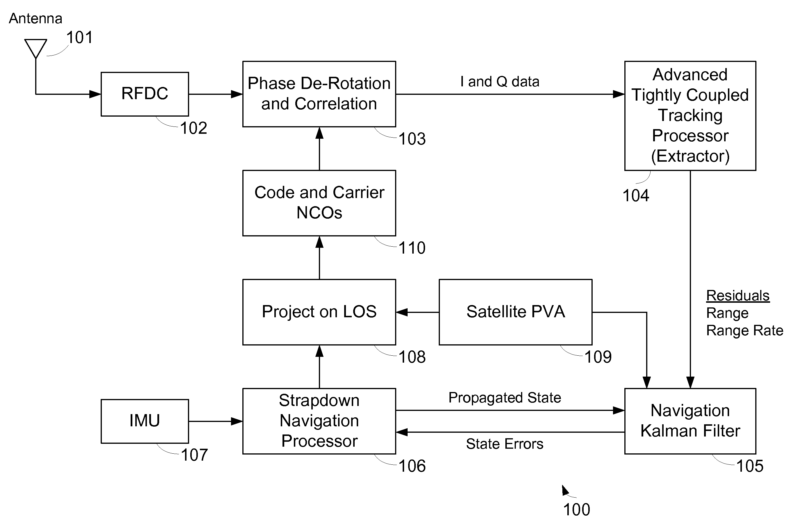
[0042]FIG. 1 is a block diagram showing multi-satellite tracking system 100. In the system 100, satellite navigation signals are received by an antenna 101 and provided to a Radio Frequency Down Converter (RFDC) 102. Downconverted signals from the RFDC 102 are provided to a phase de-rotation and correlation block 103. De-rotated and correlated signals from block 103 are provided to an ATC tracking processor 104. The ATC tracking processor 104 provides residuals of range, range rate and range acceleration to a 24-state navigation Kalman filter 105. Navigation state errors from the Kalman filter 105 are provided to a strapdown navigation processor block 106. Navigation data from an Inertial Measurement Unit (IMU) 107 are provided to the strapdown navigation processor block 106. The strapdown navigation processor block 106 provides corrected navigation state information to a projection block 108 and propagated state information to the Kalman filter 105. Satellite Position, Velocity, an...


PUM


Abstract

A system and method for generating a navigation solution in high interference and dynamic environments using Global Positioning System (GPS) and inertial measurement unit (IMU) data is described. The system includes an Advanced Tightly Coupled (ATC) tracking processor for a multi-satellite tracking system. The ATC accepts early, late, and on-time I and Q data from the GPS signal tracker and outputs vehicle-to-satellite range and range rate residual measurements to a navigation Kalman filter. The ATC includes nonlinear discriminators which transform I and Q data into linear residual measurements corrupted by unbiased, additive, and white noise. It also includes an amplitude estimator configured to operate in rapidly changing, high power noise; a measurement noise variance estimator; and a linear residual smoothing filter for input to the navigation filter.

Description

GOVERNMENT RIGHTS[0001]This invention was made with Government support under contract DAAH01-01-C-R085 awarded by the U.S. Army Aviation and Missile Command. The Government has certain rights in the invention.BACKGROUND OF THE INVENTION[0002]1. Field of the Invention[0003]The invention relates to a new method of combining GPS and inertial navigation system (INS) sensor measurements for the purpose of navigating in the presence of interfering signals.[0004]2. Description of the Related Art[0005]The Global Positioning System has revolutionized navigation. Prior to the twentieth century, land and sea navigation was performed using angle measurements to celestial bodies, magnetic compass measurements, and time measurements from an accurate clock to determine longitude. At the beginning of the twentieth century, the first airplane flight foreshadowed the need for more accurate navigation systems. Radio and inertial navigation systems soon supplanted the old methods.[0006]Terrestrial navi...

Claims


Application Information

Patent Timeline
Patent Type & Authority Patents(United States)
IPC IPC(8): G01S5/14G01C21/00G01S19/26
CPCG01C21/005G01S19/26
Inventor CRANE, ROBERTALEXANDER, STEVEBESER, JACQUESWYMAN, JEFF
Owner L3 TECH INC
Why Eureka
Try Eureka