Global positioning system accuracy enhancement

a global positioning system and enhancement technology, applied in the field of global positioning system accuracy, can solve the problems of increasing ttc bandwidth limitations, affecting and various types of errors, so as to reduce the errors inherent in gps data and improve the accuracy of navigation solutions calculated by user equipment receiving gps data and gps correction data.

Active Publication Date: 2011-06-28
THE BOEING CO
View PDF5 Cites 15 Cited by
  • Summary
  • Abstract
  • Description
  • Claims
  • Application Information

AI Technical Summary

Benefits of technology

[0008]Methods and systems described herein provide for GPS augmentation utilizing a LEO satellite constellation. By utilizing a LEO satellite constellation in the manners described below, GPS correction data can be disseminated worldwide in a timely manner and used to reduce the errors inherent in the GPS data received from the GPS satellites. As a result, the accuracy of the navigation solutions calculated by user equipment receiving the GPS data and the GPS correction data is significantly enhanced. To utilize the LEO satellite constellation for broadcasting the GPS correction data without compromising the performance of the LEO satellites with respect to unrelated broadcast duties, the GPS correction data is broadcast in messages utilizing only a subset of the total number of available spot beams for each LEO satellite. The subset of spot beams is calculated utilizing a number of factors, including but not limited to, satellite angular velocity, bandwidth constraints, and message latency estimates.

Problems solved by technology

However, this data, as well other data transmitted by the GPS satellites, is subject to various types of errors that can affect the precise determination of the position of a GPS receiver as well as any other navigation solution.
A disadvantage of relying on these daily uploads is that the errors inherent in the broadcast message from the GPS satellites grows proportional to the time from the latest upload and include a residual component relative to the ability of the GPS control segment on the ground to estimate these uploaded parameters.
For example, the TTC aspects of the GPS are characterized by a limited number of ground antennas, TTC bandwidth limitations, large upload data size requirements for any potential autonomous operations, and limitations associated with human control of the TTC system.
However, these systems do not provide adequate correction data with adequate frequency to user equipment around the world.
As a result, user equipment remains subjected to errors in the GPS data to an extent that prevents accurate and precise calculation of navigation solutions.

Method used


Image

  • Global positioning system accuracy enhancement
  • Global positioning system accuracy enhancement
  • Global positioning system accuracy enhancement

Examples


Embodiment Construction

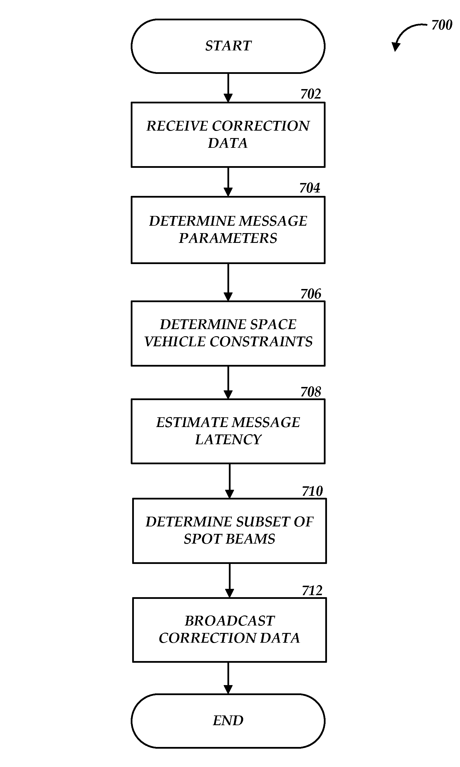
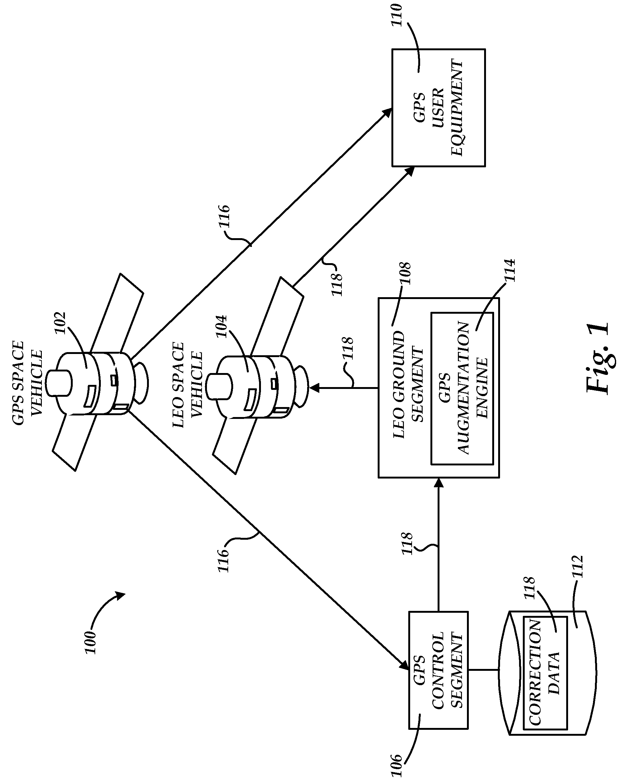
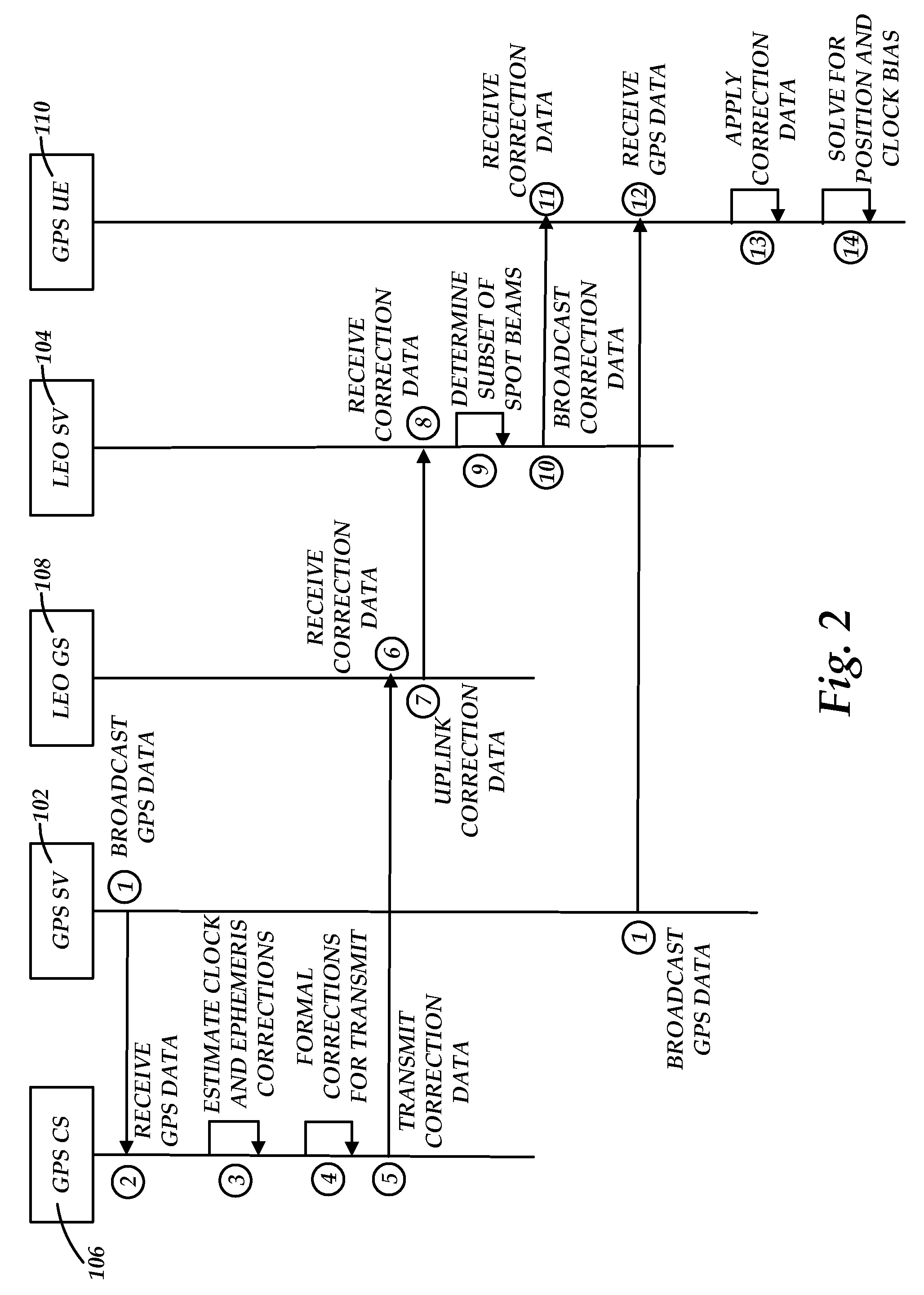
[0021]The following detailed description is directed to methods and systems for augmenting the GPS to enhance accuracy. As discussed briefly above, GPS data broadcasted by the GPS satellite constellation is subject to errors that increase proportionally with the time from the last upload to the GPS satellites, or space vehicles, from the GPS control segment on the earth. To mitigate the error growth, and consequently increase the accuracy of the navigational position determinations made by the user equipment receiving GPS data from the GPS satellite constellation, the embodiments described below utilize a constellation of LEO space vehicles to relay GPS correction data to user equipment.

[0022]The user equipment may then utilize the GPS correction data received from the LEO space vehicle and the received GPS data from the GPS space vehicles to calculate position and other navigational data. Because embodiments described below utilize an existing constellation of LEO space vehicles th...


PUM


Abstract

Methods and systems enhance the accuracy of the global positioning system (GPS) using a low earth orbiting (LEO) satellite constellation. According to embodiments described herein, GPS data is received from GPS satellites at a GPS control segment and is used to create GPS correction data to be utilized by user equipment to correct errors within the GPS data. The GPS correction data is transmitted from the GPS control segment to a LEO ground segment, where it is uplinked to the LEO satellite constellation. To account for bandwidth constraints and minimize any performance degradation of the LEO satellites, the GPS correction data is broadcast to earth on a subset of the total number of available spot beams. The subset of spot beams is selected in part according to satellite angular velocity, bandwidth constraints, and message latency estimates.

Description

CROSS-REFERENCE TO RELATED APPLICATIONS[0001]This patent application is a non-provisional patent application of U.S. Provisional Patent Application Ser. No. 61 / 109,709 entitled “Global Positioning System Accuracy Enhancement,” filed Jan. 8, 2008, which is incorporated herein by reference in its entirety.TECHNICAL FIELD[0002]The present disclosure relates generally to global positioning system (GPS) accuracy, and more particularly to enhancing the accuracy of a GPS system using a low earth orbiting (LEO) satellite constellation.BACKGROUND[0003]GPS technology utilizes a constellation of orbiting satellites that transmit data to GPS receivers on earth. The GPS receivers use the data received from three or more satellites to determine location, speed, direction, and time. The GPS data transmitted by the GPS satellites includes atomic clock and satellite ephemeris data that is important to the accurate determination of the position and other navigational information corresponding to a GP...

Claims


Application Information

Patent Timeline
Patent Type & Authority Patents(United States)
IPC IPC(8): G01S19/41
CPCG01S19/07G01S19/071
Inventor DILELLIO, JAMES A.CAROLIPIO, EDWARDCHIEN, JYA-SYIN WUGHASSAEI, KAMRAN
Owner THE BOEING CO
Why Eureka
Try Eureka