Method and system for interactive geological interpretation, modeling and restoration

a geological interpretation and interactive technology, applied in the field of methods and systems for geological analysis of geologic structures, can solve the problems of limited flexibility, inconvenient use, and inability to adapt to the needs of existing computer-implemented systems, and achieve the effect of reducing the number of errors, reducing and improving the accuracy of the analysis

Active Publication Date: 2014-08-05
NUNNS ALAN GORDON
View PDF11 Cites 31 Cited by
  • Summary
  • Abstract
  • Description
  • Claims
  • Application Information

AI Technical Summary

Benefits of technology

[0014]The present invention is directed to a more approachable computer-implemented method and system to simplify, expedite and optimize the process of interactive geological interpretation, modeling and restoration, wherein the both a qualitative and quantitative approach is supported in a hybrid manner. The computer-implemented method and system comprises a suitable computer system to implement the method of the invention via a software module supporting interactive geological interpretation, modeling and restoration. A pre-existing earth profile, comprised of seismic data, well bore data, annotations and other geologic information is first imported into the system and displayed on a graphical window for interaction by an interpreter, typically a geologist or geophysicist. The interpreter interprets and models the earth profile interactively using graphical tools which cause the interpretation and model to be instantly computed and overlaid on the backdrop of the originally imported earth profile. Once a new interpretation and model is instantly computed, the interpreter can compare the interpretation and model to the earth profile. Additionally, the interpreter can direct the software to animate the structural development of the earth profile according to the interpretation and model for further assessment. The interpreter may then assess whether the current interpretation and model is satisfactory and delivers an improved understanding of fault and reservoir shapes, structural correlations, structural history and stratigraphic history. Finally, the interpreter can output the interpretation and model as a solution file for further analytical iteration or for use in other geologic interpretation systems.
[0015]The method and system of the present invention can instantly restore interpreted earth profiles, including seismic reflection sections and geological sections by flattening with respect to a reference horizon while restoring slip across faults that intersect the horizon. Further, the present invention supports unraveling structural and stratigraphic history, checking seismic correlations across faults and revealing subtle features and relationships that have been masked by tectonic dissection. In one embodiment, the present invention supports structural restoration techniques which are more useful than the simple flattening in many seismic interpretation systems, which does not take fault slips into account.
[0018]The present invention supports and delivers several advantages and features, some of which are described below. For example, the present invention provides a method and system to optimally integrate a hybrid qualitative and quantitative approach to interpretation, modeling and restoration using interactive and iterative computer-implemented methods and geologic models to expedite analysis and produce more confident results. Further, the present invention provides a computer-implemented method and system to support training of both novice and advanced interpreters. Still further, the present invention provides a software module to support the implementation of a plurality of differing geologic interpretation models via a hybrid interactive qualitative and quantitative approach. Even further, the present invention provides a 2-D interpretation method and system that can be used to confirm and reinforce geologic interpretations as a precursor to implementation of more lengthy and expensive 3-D computer modeling systems, thereby substantially reducing cost and while improving quality of the resulting 3-D model. Further, the present invention provides a simpler approach to support and expedite correlation between seismic reflection data and well bore log data. Additionally, the present invention provides a strongly interactive interpretation and modeling approach that differs sharply from approaches where the operations are weakly interactive, follow an inflexible ordering, or require batch computations. And, still further, the present invention allows the interpretation and modeling of earth profiles on a fault-by-fault basis to support confirmation of interpretations across common fault zones.

Problems solved by technology

Because subsurface data is typically incomplete, ambiguous, and noisy, in various aspects, the interpreter may need to apply skilled judgment to effectively analyze subsurface structures.
This approach is imprecise and is also dependent on the experience of the interpreter.
Despite the presence of a body of scientific theory related to quantitative modeling and structural restoration of geologic structures, present systems have limited capability to flexibly and rapidly incorporate such modeling and restoration capabilities into the day-to-day work processes of interpreters.
In many cases, existing computer-implemented systems require substantial data input and setup before interpretation, modeling, and restoration can be performed.
Such execution is typically performed in a weakly-interactive mode where it is difficult or impossible to see useful results until a complex series of steps have been completed, which can take days and even weeks.
Still further, these complex systems do not readily lend themselves to use in training where real-time response is required to convey and communicate various geological modeling and restoration concepts and theories in a timely manner.

Method used


Image

  • Method and system for interactive geological interpretation, modeling and restoration
  • Method and system for interactive geological interpretation, modeling and restoration
  • Method and system for interactive geological interpretation, modeling and restoration

Examples


Embodiment Construction

Overview of Method and System—FIGS. 1-3

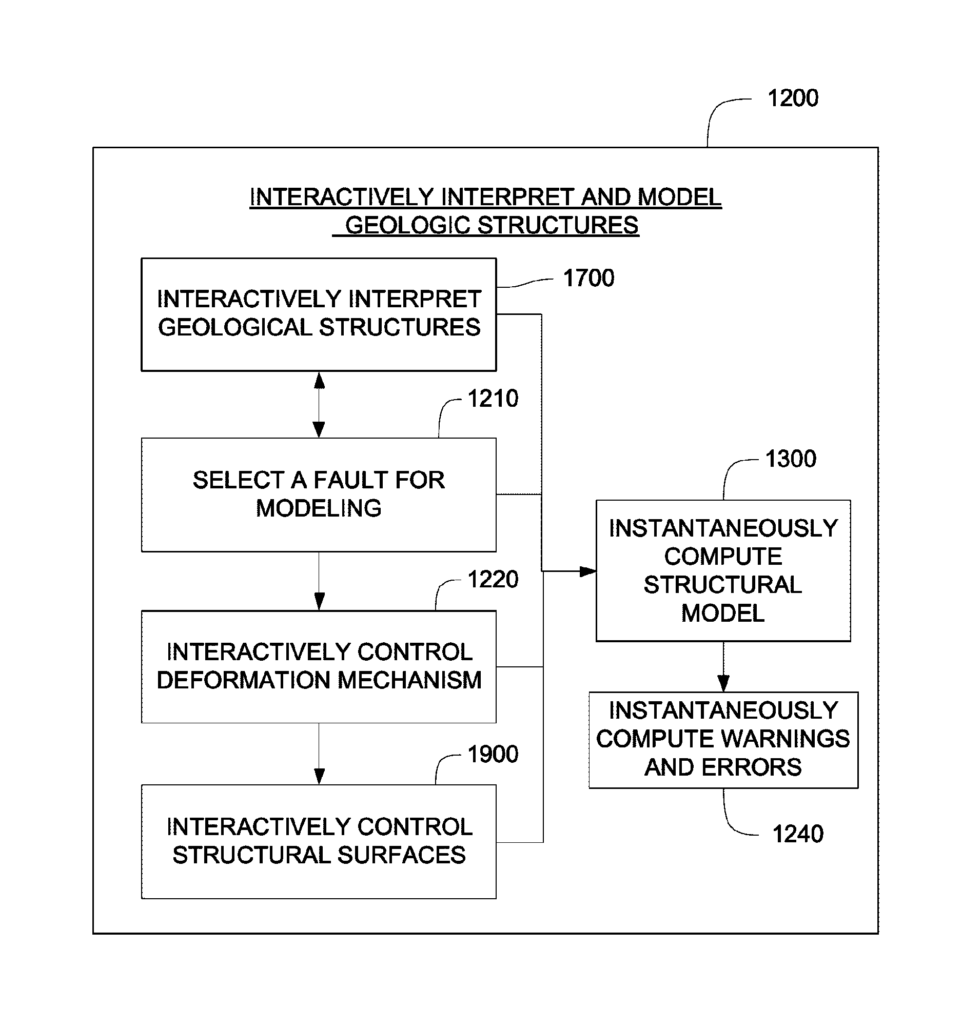
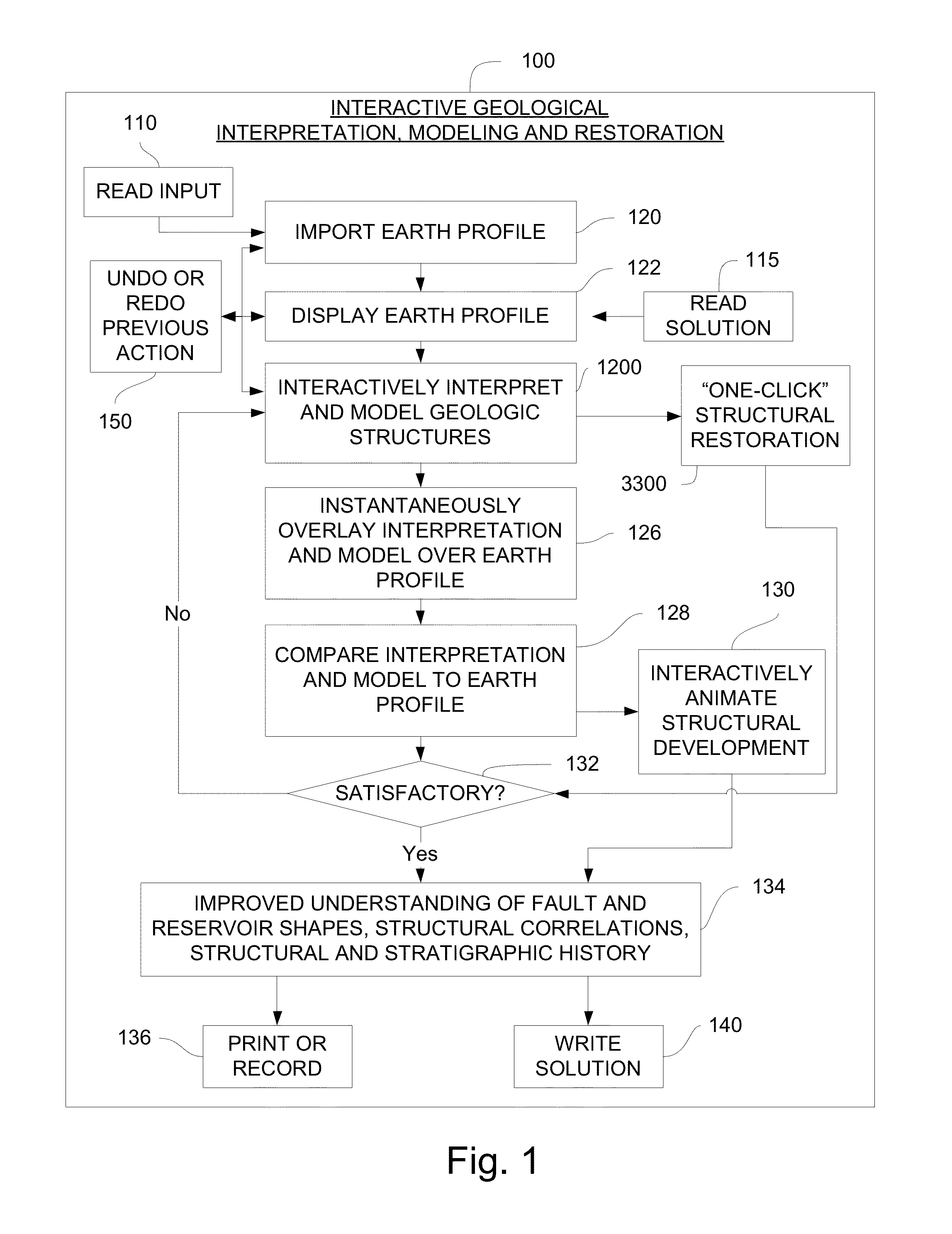
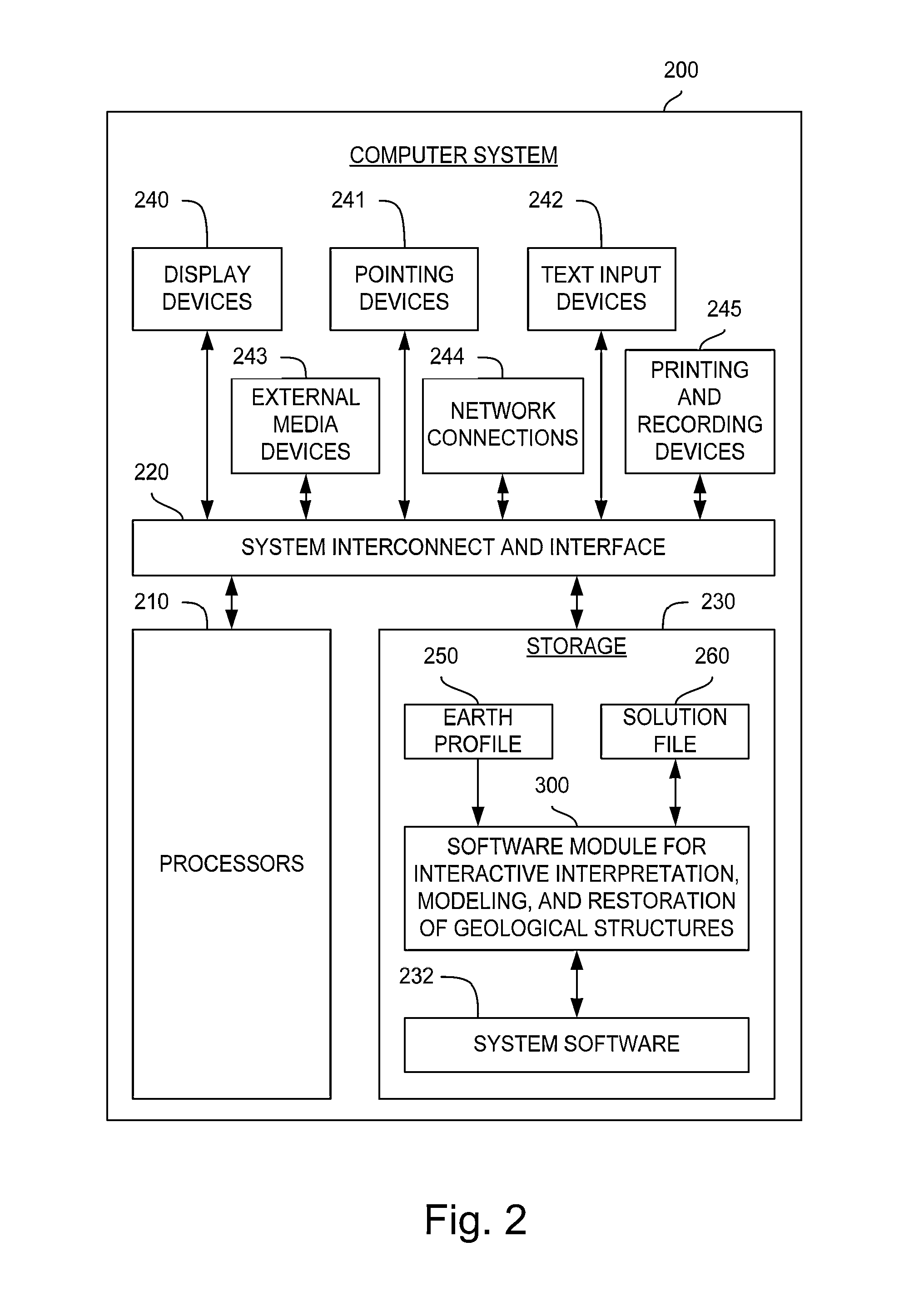
[0065]With reference to FIG. 1, the invention comprises a method 100 for interactive geological interpretation, modeling, and restoration that is implemented on a suitable computer system 200, shown in FIG. 2. A software module 300 is loaded into and executed by the computer system 200 to implement the method 100 of the invention. The method and system are employed by a technician or scientist, such as an earth scientist, geologist or geophysicist, hereinafter called an “interpreter”. Using the method and system the interpreter can make skilled qualitative and quantitative appraisals of geologic structures that occur within the upper parts of the earth's crust, including both the current state of such structures and their kinematic development through time. One use of such appraisals is to evaluate resources found in structures within sedimentary basins in the upper parts of the earth's crust, including but not limited to oil and gas resources....


PUM


Abstract

The present invention comprises a computer-implemented method for interactive geological interpretation, structural modeling and structural restoration, in which instantaneous feedback is provided to an interpreter. A software module is loaded into and executed by the computer system to implement the method of the invention. The method and system are employed by a technician or scientist, such as an earth scientist, geologist or geophysicist, hereinafter called an “interpreter”. Using the method and system, the interpreter can make skilled qualitative and quantitative appraisals of geologic structures that occur within the upper parts of the earth's crust, including both the current state of such structures and their kinematic development through time. One use of such appraisals is to evaluate resources found in structures within sedimentary basins, including but not limited to oil and gas resources. The method and system can be used to train novice and advanced interpreters to improve their understanding.

Description

CROSS-REFERENCE TO RELATED APPLICATIONS[0001]This application claims the benefit of U.S. Provisional Application No. 61 / 382,924, filed Sep. 15, 2010.STATEMENT REGARDING FEDERALLY SPONSORED RESEARCH OR DEVELOPMENT[0002]Not Applicable.THE NAMES OF THE PARTIES TO A JOINT RESEARCH AGREEMENT[0003]Not Applicable.INCORPORATION-BY-REFERENCE OF MATERIAL SUBMITTED ON A COMPACT DISC[0004]Not Applicable.BACKGROUND[0005]1. Field of the Invention[0006]The present invention and associated embodiments and versions relate to methods and systems for geological analysis of geologic structures.[0007]2. Description of Related Art[0008]Earth scientists, geologists and geophysicists engaged in evaluating petroleum resources in the upper parts of the earth's crust typically analyze a range of subsurface data, including such data as 2D and 3D seismic reflection data and log data from well bores. The objective of the analysis is to determinate the likely configuration and nature of rocks and fluids in the su...

Claims


Application Information

Patent Timeline
Patent Type & Authority Patents(United States)
IPC IPC(8): G06G7/48G06F7/48G01V99/00
CPCG06F2217/16G01V2210/74G01V99/005G01V2210/64G01V2210/66G01V2210/72G06F2111/10
Inventor NUNNS, ALAN, GORDON
Owner NUNNS ALAN GORDON
Why Eureka
Try Eureka