Methods, systems and machines for identifying geospatial compatibility between consumers and providers of goods or services

a technology of geospatial compatibility and consumer, applied in the direction of structured data retrieval, electric digital data processing, instruments, etc., can solve the problems of many users being engulfed in “information overload, consumer does not know if they are not finding, and consumers are not able to easily and accurately locate specific information, so as to improve the access of each other and locate the effect of specific information easily and accurately

Active Publication Date: 2015-01-06
STREICH JUSTIN
View PDF24 Cites 8 Cited by
  • Summary
  • Abstract
  • Description
  • Claims
  • Application Information

AI Technical Summary

Benefits of technology

This patent describes a system that allows users to access information related to their local markets through a machine that has been designed using geospatial characteristics. The machine has built-in tools that make it easy for users to connect to a central database and retrieve information. The system also excludes irrelevant information based on the user's location, saving time and ensuring more relevant results. The technical effect of this patent is the creation of a machine that makes it easier for users to access relevant information while saving time and avoiding unnecessary searches.

Problems solved by technology

However, as the information available grows by an order of magnitude as time goes on, many user become bogged down in “information overload” when they attempt to use the Internet to search for specific information.
In the case of local merchants and service providers, the Internet simultaneously offers more and often better choices to consumers over using traditional methods and makes those choices harder to find by the vast amount of information that must be manually combed through to determine its validity.
In other words, the consumer does not know if they are not finding what they want because they have not entered the proper search terms or if it is simply not there.
This is further complicated because companies that design web pages are familiar with the tactics that can move their clients' web page up in the rankings of popular web search engines.
This floods a consumer with a large amount of false positives that results in a lot of wasted time.
Often, some of the information required is not made available unless the consumer calls the advertiser.
Again, this results in hassle for the consumer and wastes time.
These processes are contrary to the modern person's desire and need to obtain the information they seek quickly and efficiently.
The reason these problems exist is because the current solutions do not utilize tools that can assist the consumer to vastly narrow down their search results.
Even if they did, virtually all information on the Internet does not contain the necessary infrastructure to permit these tools to be used optimally.
They statically geocode users (assign one location) and do not appear to allow a user to define multiple locations.
They go so far as to have document reading and voice recognition software to interpret commands, requests and responses so that they can facilitate the partial automation of the Vendor's business, resulting in a relatively complex system.
This patent's means of determining the location to be geocoded may be considered quite inefficient—if a provided address does not geocode, increasingly wider ranges of landmarks must be specified until a geocode can be discovered.
U.S. Patent Application Publication 2004 / 0133471 teaches pay for performance advertising, but appears to lack a sophisticated “geospatial query”.
While the prior art teaches how we can query a plurality of known areas defined as polygons stored in various types of databases, it does not appear to teach dynamic addition, modification or removal of polygons by someone who is not trained in or familiar with the art.
This is a problem when data associated with geographical points or zones and the points and zones themselves must be able to be added, removed, re-associated or otherwise modified simultaneously and in real time by a plurality of users.
As the simultaneous user count increases, it becomes prohibitively expensive to hire, train and provide infrastructure to administrators that can affect the required changes on behalf of the users.

Method used


Image

  • Methods, systems and machines for identifying geospatial compatibility between consumers and providers of goods or services
  • Methods, systems and machines for identifying geospatial compatibility between consumers and providers of goods or services
  • Methods, systems and machines for identifying geospatial compatibility between consumers and providers of goods or services

Examples


Embodiment Construction

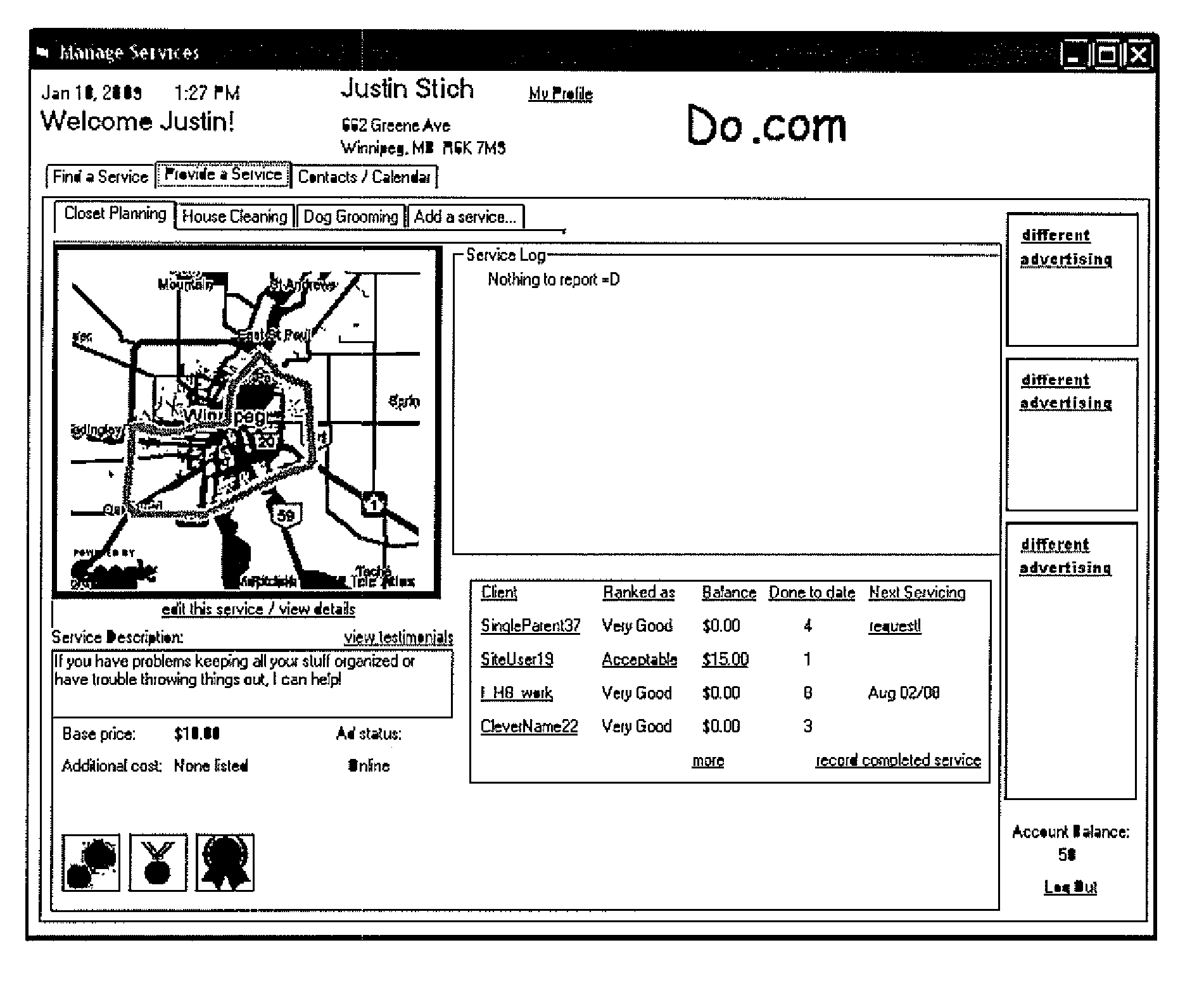
[0182]A process whereby providers of goods and services can explicitly define the area in which they are willing to travel to perform services or deliver goods by defining a polygon on a digital map. If goods or services are available at a location where consumers must physically go to in order to obtain the goods or services, a point may be defined on a digital map to disclose the location or an address may be provided which is then geocoded through an online geocoding service. A database of locations (defined as a “point” which is a geographical location defined by a latitude and longitude coordinate) and polygons shapes (which are indexed lists of points which when reconstructed in the order of the index, reproduce the original shape on a digital map by straight-line interconnection of the points in the indexed sequence) is kept and each element in this database is assigned a Master Identification Number (MID#) based on the user that created the point or shape. This “Location Dat...


PUM


Abstract

Geospatial compatibility between consumers and providers of goods or services is identified. The system allows consumers to find service providers with service areas encompassing their location or merchants within a desired shopping area, and allow consumers to query about consumers within a specified area, for example to identify a potential customer base or consider regional advertising. A digital map interface allows users to enter one or more locations or areas of interest and later performs location or area additions, modifications or removals. The system provides the geospatially matched consumers and vendors with information on how to contact one another, but is kept simple by leaving actual contact between the matched parties to separate outside communication channels independent of the system. Processing requirements are reduced by pre-calculating an inner rectangle for complex polygon geographical areas so that simple point-rectangle calculations can confirm locations within the area as being within the polygon.

Description

FIELD OF THE INVENTION[0001]The present invention relates to tools useful by consumers to seek out service providers with a service area encompassing the consumer's location or merchants located within a consumer-specified geographical area, and by providers of goods or services to locate a potential customer base within a geographical area of interest.BACKGROUND OF THE INVENTION[0002]The Internet has become a vast source of information, accessible by the majority of North Americans. However, as the information available grows by an order of magnitude as time goes on, many user become bogged down in “information overload” when they attempt to use the Internet to search for specific information. In the case of local merchants and service providers, the Internet simultaneously offers more and often better choices to consumers over using traditional methods and makes those choices harder to find by the vast amount of information that must be manually combed through to determine its val...

Claims


Application Information

Patent Timeline
Patent Type & Authority Patents(United States)
IPC IPC(8): G06Q30/00
CPCG06Q30/0639G06F3/0484G06F16/2457G06F16/29G06F16/444G06F16/9537G06Q30/06
Inventor STREICH, JUSTIN
Owner STREICH JUSTIN
Why Eureka
Try Eureka