Systems, methods, devices and subassemblies for creating and delivering a GNSS augmentation service

a technology of gnss and augmentation service, applied in the field of systems, methods, devices and subassemblies for creating and delivering gnss augmentation services, can solve the problems of limiting radio navigation systems to local two, not addressing many interesting positioning problems, and rtk systems are typically fairly expensive, so as to improve the time to achieve geometric diversity, improve the quality of pvt coverage, and reduce the convergence time

Inactive Publication Date: 2017-01-31
APPLE INC
View PDF4 Cites 25 Cited by
  • Summary
  • Abstract
  • Description
  • Claims
  • Application Information

AI Technical Summary

Benefits of technology

[0010]It has been discovered that position, velocity, and / or timing (PVT) solutions may be provided with levels of precision that have previously and conventionally been associated with RTK and PPP systems without many of the drawbacks. Using the augmentation techniques described herein, high-precision PVT solutions may be provided without resort to a generally proximate, terrestrial ground station having a fixed and precisely known position. Instead, techniques described herein utilize a series of reference stations that track one or more combinations of traditional GNSS satellites that are in MEO, geostationary satellites, geosynchronous satellites, terrestrial beacons, low earth orbiting (LEO) satellites, and / or the like. The LEO satellites may include one or more satellites in the Iridium constellation. The use of the shorter orbital period LEO satellites significantly improves the time to achieve geometric diversity, reducing convergence time from 30 minutes down to as little as 1 or 2. In addition, the use of the orbital diversity of some LEO satellites also provides better high-precision PVT coverage at high latitudes and in challenging environments, thus providing higher deployment flexibility.

Problems solved by technology

Limiting radio navigation systems to local two-dimensional positioning, however, does not address many interesting positioning problems.
RTK systems are typically fairly expensive, require time to set-up the base station, and the base station and mobile unit need to stay within a close proximity to each other.
While less expensive than RTK systems, a GNSS receiver in a PPP system generally takes up to 30 minutes to converge on a high precision PVT solution and provides poor coverage at high latitudes or in challenging environments such as cities, steep terrain, and heavily wooded areas.

Method used


Image

  • Systems, methods, devices and subassemblies for creating and delivering a GNSS augmentation service
  • Systems, methods, devices and subassemblies for creating and delivering a GNSS augmentation service
  • Systems, methods, devices and subassemblies for creating and delivering a GNSS augmentation service

Examples


Embodiment Construction

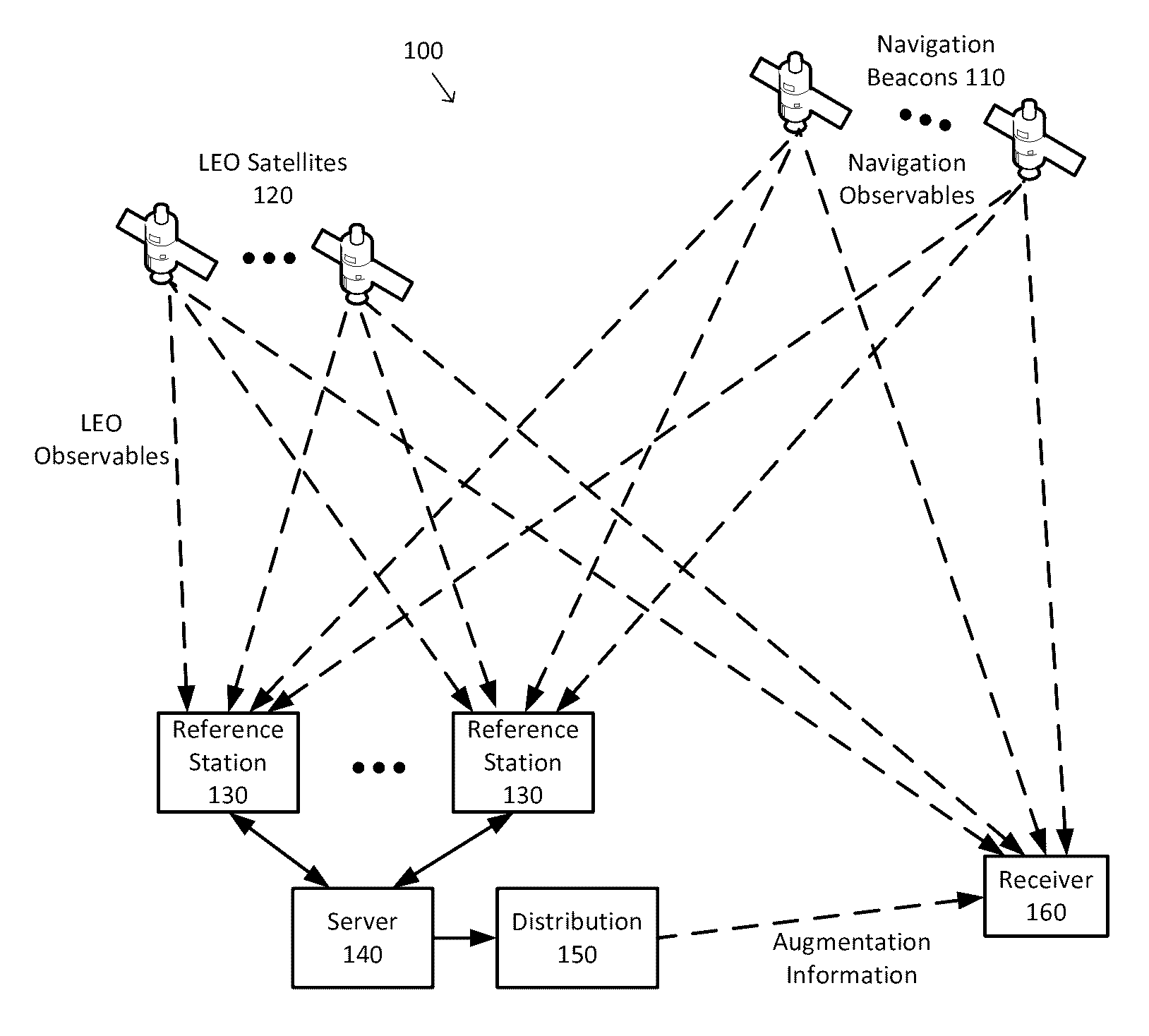
[0020]FIG. 1 is a simplified diagram of an augmented radio navigation system 100 according to some embodiments. As shown in FIG. 1, augmented radio navigation system 100 includes one or more navigation beacons 110 and one or more LEO satellites 120. In some embodiments, the navigation beacons 110 may include MEO satellites, geostationary satellites, geosynchronous satellites, terrestrial beacons, and / or the like. In some examples, the LEO satellites 120 may also be referred to as navigation beacons. In some examples, the MEO satellites may be GPS satellites and / or the LEO satellites 120 may be Iridium satellites. Each of the navigation beacons 110 and the LEO satellites 120 transmit one or more signals that may become navigation and LEO observables, respectively, when they are received by one or more reference stations 130. Depending upon the locations of the navigation beacons 110, the LEO satellites 120, and the reference stations 130, each of the reference stations 130 may observ...


PUM


Abstract

Systems, methods, devices and subassemblies for creating and delivering a GNSS augmentation service include one or more reference stations for receiving signals transmitted by navigation beacons and an augmentation server coupled to the reference stations. At least one of the reference stations is able to receive at least one of the signals from a low earth orbit satellite. Each of the reference stations determines first navigation observables based on the received signals and transmit information associated with the first navigation observables to the augmentation server. The augmentation server is configured to determine and distribute augmentation information to a receiver. The augmentation information is based on the received information associated with the first navigation observables, locations of the reference stations, and computational models. The distributed augmentation information is usable by the receiver to determine a high-precision position, velocity, and time solution for the receiver based on second navigation observables associated with the receiver.

Description

CROSS-REFERENCE TO RELATED APPLICATION(S)[0001]The present application claims priority of U.S. provisional application 61 / 735,798, filed Dec. 11, 2012, entitled “Systems And Methods For GNSS Augmentation, Ionospheric Modeling And Observables, Communications And / Or Navigation Device Updates.” The entirety of the foregoing application is incorporated by reference herein.BACKGROUND[0002]Field of the Invention[0003]The present invention relates to the determination and generation of models and / or other augmentation information that may be used to support high-precision position, velocity, and / or timing (PVT) solutions based on signals received from overhead assets such as satellites and, in particular, to techniques suitable for providing rapid acquisition access to such PVT solutions without resort to a generally proximate, terrestrial ground station with a fixed and precisely known position.[0004]Description of the Related Art[0005]Radio signals have been used as an aid to navigation ...

Claims


Application Information

Patent Timeline
Patent Type & Authority Patents(United States)
IPC IPC(8): G01S19/46G01S19/38G01S19/45G01S19/05G01S19/07
CPCG01S19/46G01S19/05G01S19/07G01S19/073
Inventor MILLER, ISAAC T.BENCZE, WILLIAM J.BRUMLEY, ROBERTLEDVINA, BRENT M.
Owner APPLE INC
Why Eureka
Try Eureka