Visual localization within LIDAR maps

a lidar map and visual localization technology, applied in the field of visual localization, can solve the problems of inability to use without an intricate observability model, confusion of the localization pipeline, and insufficient increase in the quality of registration to justify the additional rendering cost, etc., and achieve the effect of confusing the localization pipelin

Active Publication Date: 2018-06-05
RGT UNIV OF MICHIGAN
View PDF22 Cites 11 Cited by
  • Summary
  • Abstract
  • Description
  • Claims
  • Application Information

AI Technical Summary

Benefits of technology

[0006]The cost of 3D LIDAR scanners is prohibitive for consumer grade automobiles. Quite likely the greatest near-term enabler for self-driving cars is the increased use of camera systems in place of expensive LIDAR scanners. Cameras provide a low-cost means to generate extremely rich, dense data that is suitable for localization.
[0089]In this patent disclosure, we showed that a single monocular camera can be used as an information source for visual localization in a 3D LIDAR map containing surface reflectivities. By maximizing normalized mutual information, we are able to register a video stream to our prior map. Our system is aided by a GPU implementation, leveraging OpenGL to generate synthetic views of the environment; this implementation is able to provide corrective positional updates at ˜10 Hz. Moreover, we compared our algorithm against the state-of-the-art LIDAR-only automated vehicle localization, revealing that the present teachings can achieve a similar order of magnitude error rate, with a sensor that is several orders of magnitude cheaper.

Problems solved by technology

However, these features frequently vary with time of day and weather conditions, and cannot be used without an intricate observability model.
However, their method assumes a flat ground, whereas our projective registration allows for more complex ground geometries and vertical structures.
With both of these methods, small errors in stereo pair matching can lead to oddly distorted orthographic reconstructions, thus confusing the localization pipeline.
This sensor registration has mostly been considered an offline task due to the expense of generating synthetic views for calibration.
We originally intended to incorporate the full 3D structure in our prior map, including buildings, street poles, etc., but found that the added structure did not appreciably increase registration quality enough to warrant the additional rendering cost (the 3D structure doubled scene prediction time).
However, we did find that it was extremely important to use a mesh-surface as opposed to a strict planar texture because the planar texture did not accurately depict the curvature of the road (e.g., gutters sunken), as can be seen in the map colored by z-height in FIG. 3C.
Correlative methods can only measure either a negative or positive correlation and often fails under varying illumination.
Note that it would be quite difficult to create a hand-tuned feature detector that could identify this type of information for localization.
This dataset presents a complicated environment for localization as half of the dataset is through a parking lot with infrequent lane markings.
Ideally, we should be able to perfectly register our prior map, however, due to noise or insufficient visual variety in the environment, we end up with a distribution of lateral and longitudinal errors.
This is caused by areas that are visually feature poor or obstructed by significant obstacles; for example, lane markings can often be perceived by the survey vehicle's LIDAR scanners and captured in our prior map, yet the subtle transition between pavement and faded lane markings cannot be observed by our camera.
Note that the Stadium results show a rather large variance in longitudinal error; this is because half of the dataset is through a parking lot containing little visual variation.

Method used


Image

  • Visual localization within LIDAR maps
  • Visual localization within LIDAR maps
  • Visual localization within LIDAR maps

Examples


Embodiment Construction

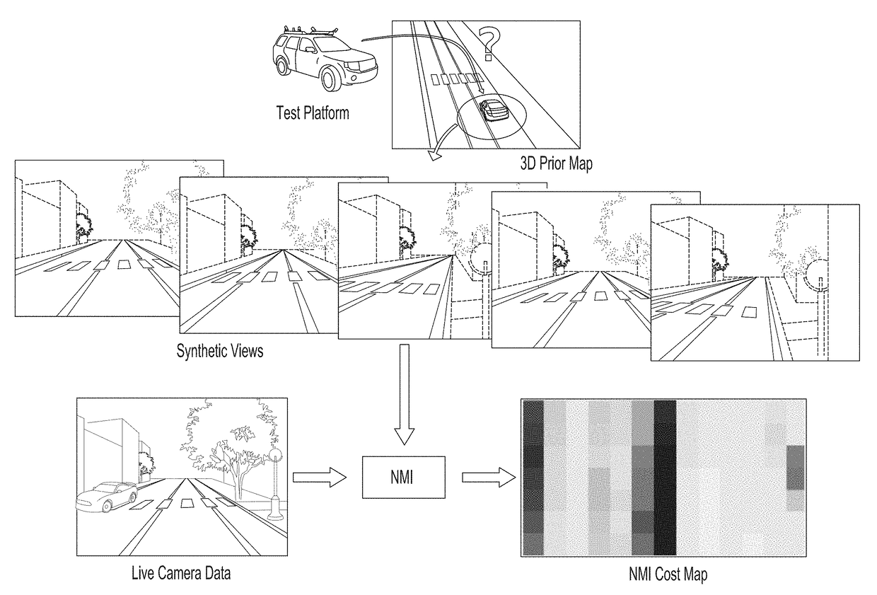
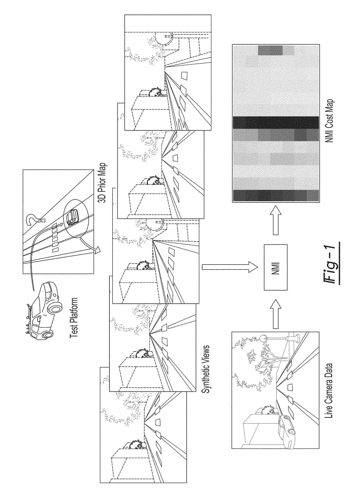
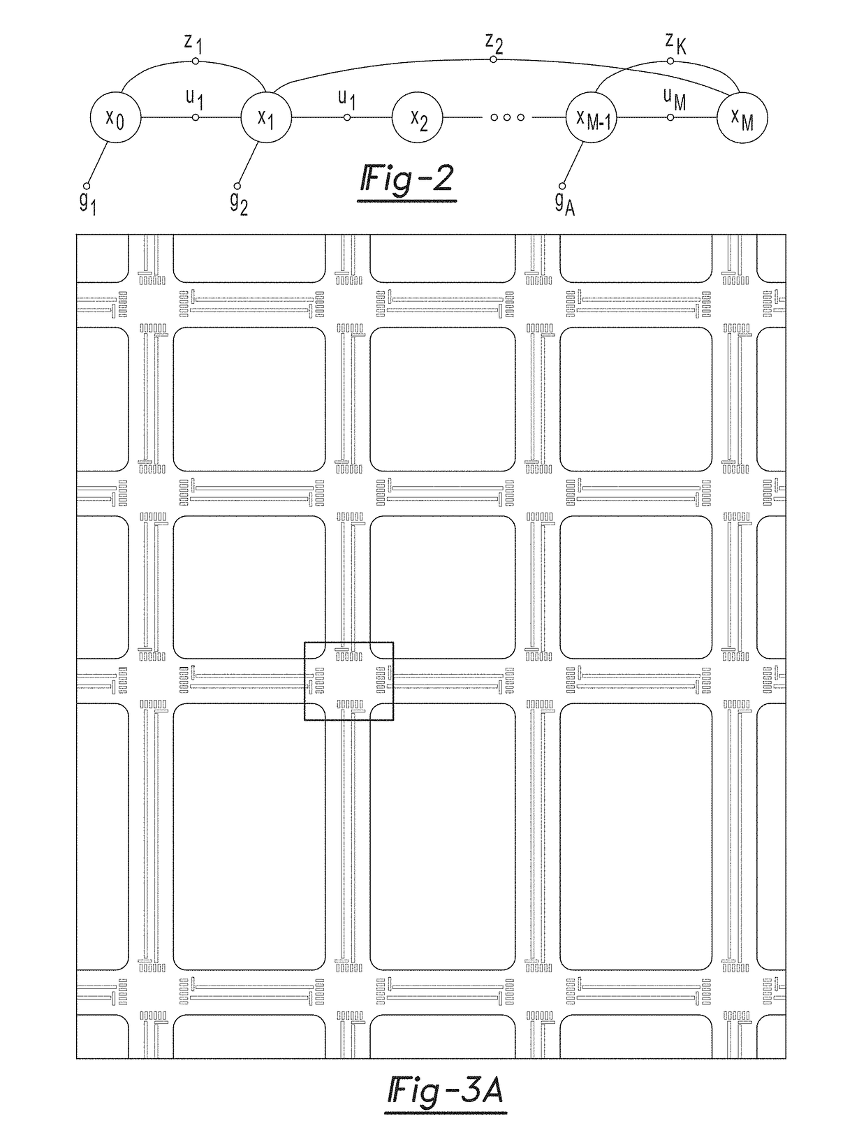
[0026]Example embodiments will now be described more fully with reference to the accompanying drawings.

[0027]Example embodiments are provided so that this disclosure will be thorough, and will fully convey the scope to those who are skilled in the art. Numerous specific details are set forth such as examples of specific components, devices, and methods, to provide a thorough understanding of embodiments of the present disclosure. It will be apparent to those skilled in the art that specific details need not be employed, that example embodiments may be embodied in many different forms and that neither should be construed to limit the scope of the disclosure. In some example embodiments, well-known processes, well-known device structures, and well-known technologies are not described in detail.

[0028]The terminology used herein is for the purpose of describing particular example embodiments only and is not intended to be limiting. As used herein, the singular forms “a,”“an,” and “the” ...


PUM


Abstract

An apparatus and method for visual localization of a visual camera system outputting real-time visual camera data and a graphics processing unit receiving the real-time visual camera data. The graphics processing unit accesses a database of prior map information and generates a synthetic image that is then compared to the real-time visual camera data to determine corrected position data. The graphics processing unit determines a camera position based on the corrected position data. A corrective system for applying navigation of the vehicle based on the determined camera position can be used in some embodiments.

Description

CROSS-REFERENCE TO RELATED APPLICATIONS[0001]This application claims the benefit of U.S. Provisional Application No. 62 / 104,915, filed on Jan. 19, 2015. The entire disclosure of the above application is incorporated herein by reference.FIELD[0002]The present disclosure relates to visual localization and, more particularly, relates to visual localization within LIDAR maps using correlated real-time visual images.BACKGROUND AND SUMMARY[0003]This section provides background information related to the present disclosure which is not necessarily prior art. This section provides a general summary of the disclosure, and is not a comprehensive disclosure of its full scope or all of its features.I. INTRODUCTION[0004]In recent years, fully autonomous, self-driving cars have grown into a reality with progress in the simultaneous localization and mapping (SLAM) research community and the advent of consumer-grade three-dimensional (3D) light detection and ranging (LIDAR) scanners. Systems such a...

Claims


Application Information

Patent Timeline
Patent Type & Authority Patents(United States)
IPC IPC(8): G06K9/00G06T7/73G05D1/02
CPCG05D1/0246G05D1/0248G05D1/0274G06T7/74G06T2207/30248G05D2201/0213G06T2207/10028G06T2207/30244G06T2207/10016G06T2207/20072G06T2207/20076G06T2207/30252G06T7/75
Inventor EUSTICE, RYAN M.WOLCOTT, RYAN W.
Owner RGT UNIV OF MICHIGAN
Why Eureka
Try Eureka