Lake and marshland flooding remote sense monitoring methods based on model

A technology for remote sensing monitoring and wetlands, which is used in measurement devices, mapping and navigation, open-air water source surveys, etc.

Inactive Publication Date: 2008-01-30
BEIJING JIAOTONG UNIV
View PDF1 Cites 51 Cited by
  • Summary
  • Abstract
  • Description
  • Claims
  • Application Information

AI Technical Summary

Problems solved by technology

[0012] (1) When wetlands are flooded, it is difficult to obtain available optical remote sensing data due to the influence of weather such as cloudy, rainy, cloud, fog, etc. dynamic
This is the biggest difficulty in monitoring wetland flooding in cloudy and rainy areas in the middle and lower reaches of the Yangtze River in my country;
[0013] (2) Existing methods can only obtain the changes in the time interval of two or more remote sensing images, and it is difficult to describe the complete dynamic process of wetland flooding;
[0014] (3) It is difficult to obtain the water level data of wetland flooding through the remote sensing change detection method;
[0015] (4) The existing methods are inconvenient to apply to the remote sensing detection of wetland flood changes, and the operation is cumbersome. Generally, remote sensing image processing or related professional background personnel are required to use them;
[0016] (5) Change detection information lacks a quantitative model, and cannot be directly used by wetland researchers to model wetland processes and wetland ecological environment dynamic changes

Method used


Image

  • Lake and marshland flooding remote sense monitoring methods based on model
  • Lake and marshland flooding remote sense monitoring methods based on model
  • Lake and marshland flooding remote sense monitoring methods based on model

Examples


Embodiment Construction

[0039] The present invention will be further described in detail below in conjunction with the accompanying drawings and specific embodiments.

[0040]Using the present invention to carry out dynamic remote sensing monitoring of flooding of a lake and wetland in a cloudy and rainy area includes the following steps:

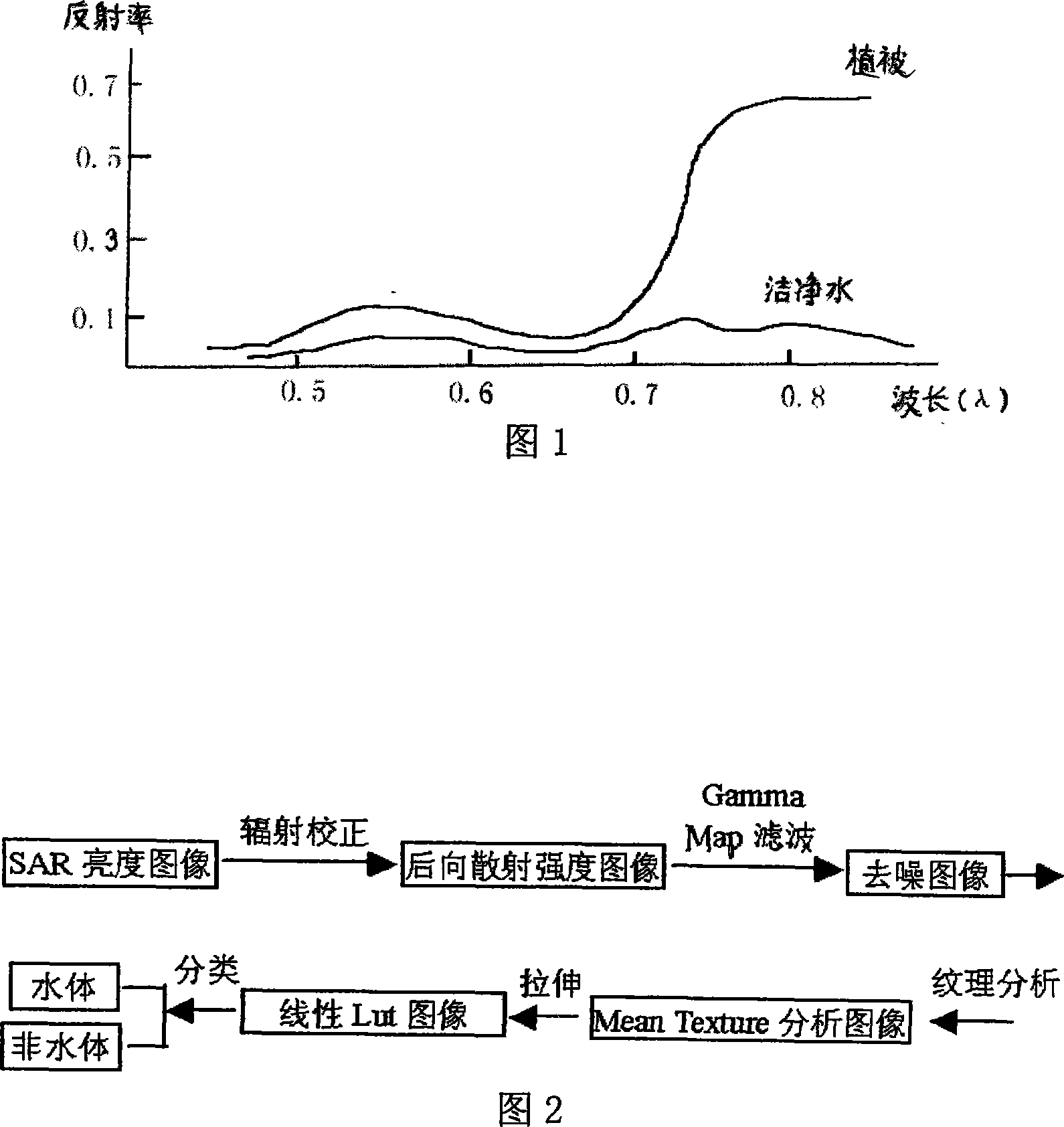
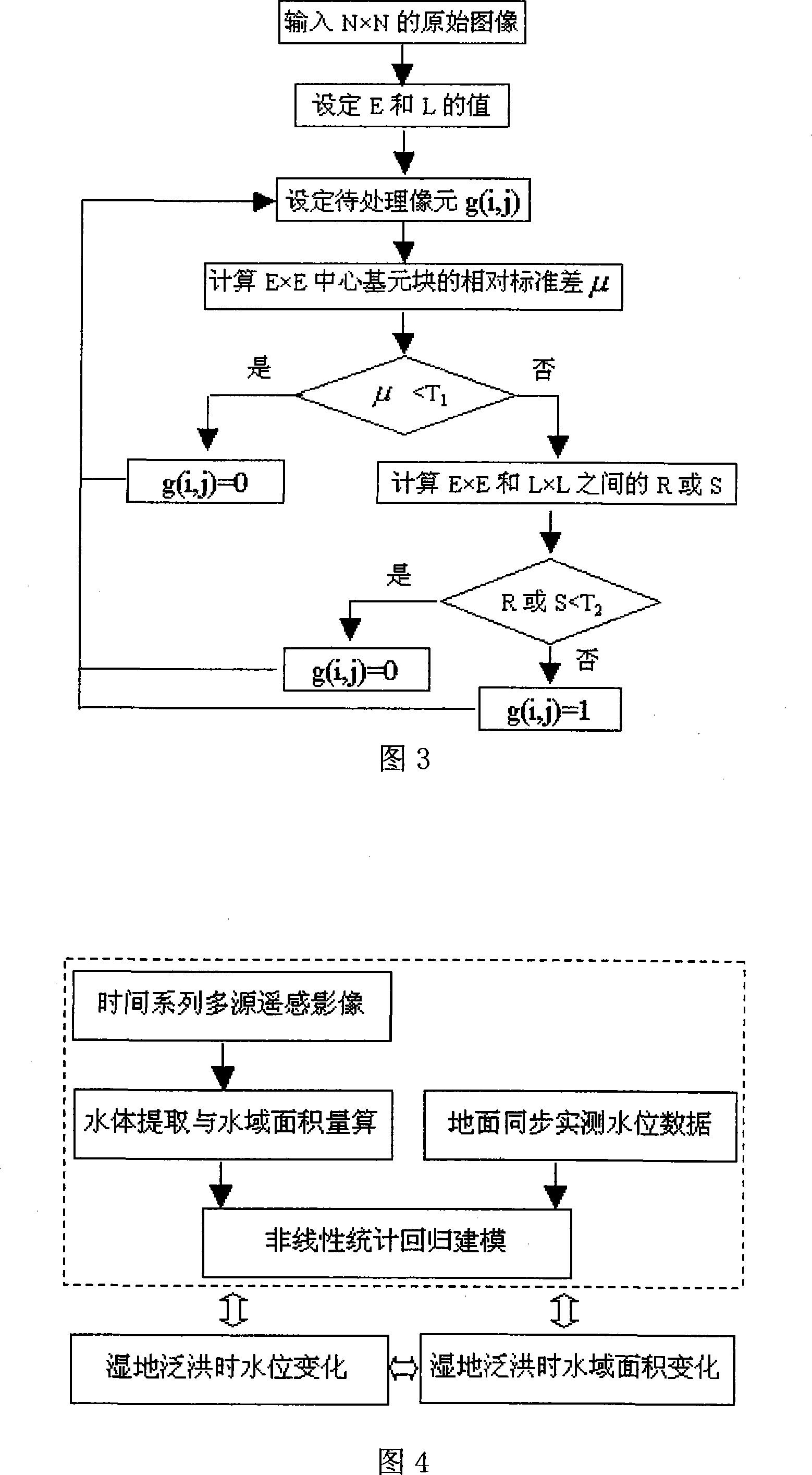
[0041] (1) Obtain multi-source remote sensing image data of lake area time series (flat water period, flood period, dry season) and perform preprocessing. Remote sensing data mainly include: Landsat TM / ETM+ images, Terra Modis satellite remote sensing data and Radarsat SAR image data. Because optical remote sensing is limited by weather conditions, it is often difficult to monitor changes in lake water area in time under cloudy and rainy weather conditions. Therefore, SAR data during flooding is essential. As far as the southern region of the middle and lower reaches of the Yangtze River is concerned, the flooding period is often accompanied by continuous rain. T...


PUM


Abstract

A lake wetland flood remote sensing monitoring method based on a model comprises the steps that: (1) the lake wetland time series multi-source remote sensing image data is acquired; (2) the water body in the remote sensing image is (semi-) automatically extracted; (3) the boundary is detected and confirmed between the water and the land, and the practical water area is calculated; (4) the data of the water area and the water level estimated by the remote sensing is carried out nonlinear statistic to modeling; (5) the acquired micro wave remote sensing image in the flood period is used, the established model is compared and validated, and the model is corrected; (6) based on the established high accuracy water area water level area distribution math model and the common remote sensing change monitoring method, the practical measured water level is combined with the acquired remote sensing image, the continuous real time monitoring to the wetland flood dynamic change is achieved. The invention can be compensated each other with a common earth surface environment change multi-time phase remote sensing image measurement method, and the invention has the important roles to the dynamic change monitoring of the wetland flood and the wetland process modeling research.

Description

technical field [0001] The invention relates to a dynamic remote sensing change monitoring method for large-scale seasonal lake wetland flooding in cloudy and rainy areas, specifically a model-based remote sensing monitoring method for lake wetland flooding, which belongs to the field of wetland ecological environment dynamic monitoring, wetland process research, and remote sensing technology application. Background technique [0002] The wetland known as the "kidney of the earth" is one of the most important living environments for human beings. Wetlands not only provide humans with a large amount of food, raw materials and water resources, but also have other ecological systems in maintaining ecological balance, regulating climate, maintaining biodiversity and rare species resources, conserving water sources, storing floods and droughts, degrading pollution, and preventing natural disasters. irreplaceable role. In addition to its own scientific research significance, wetl...

Claims


Application Information

Patent Timeline
Patent Type & Authority Applications(China)
IPC IPC(8): G01S17/89G01C13/00
CPCY02A90/30
Inventor 谭衢霖
Owner BEIJING JIAOTONG UNIV
Why Eureka
Try Eureka