High resolution ratio remote-sensing image division and classification and variety detection integration method

A remote sensing image, high-resolution technology, applied in the direction of measuring devices, electromagnetic wave re-radiation, radio wave measurement systems, etc.

Inactive Publication Date: 2008-02-20
WUHAN UNIV
View PDF0 Cites 48 Cited by
  • Summary
  • Abstract
  • Description
  • Claims
  • Application Information

AI Technical Summary

Problems solved by technology

In addition, in the literature Dell'Acqua, F.Gamba, P.Prevedini, P., Level-set based extraction and tracking of meteorological objects in satellite images, IGARSS 2000.vol.2, page (s): 627-629, using The dynamic evolution characteristics of level set theory designed a cloud target tracking system for low- and medium-resolution meteorological satellite data. For the change monitoring of multiple types of targets involved in tasks such as status investigation, the above methods are invalid, and multi-level set (the number of level set functions is greater than 1) segmentation or classification methods are required

Method used


Image

  • High resolution ratio remote-sensing image division and classification and variety detection integration method
  • High resolution ratio remote-sensing image division and classification and variety detection integration method
  • High resolution ratio remote-sensing image division and classification and variety detection integration method

Examples


Embodiment Construction

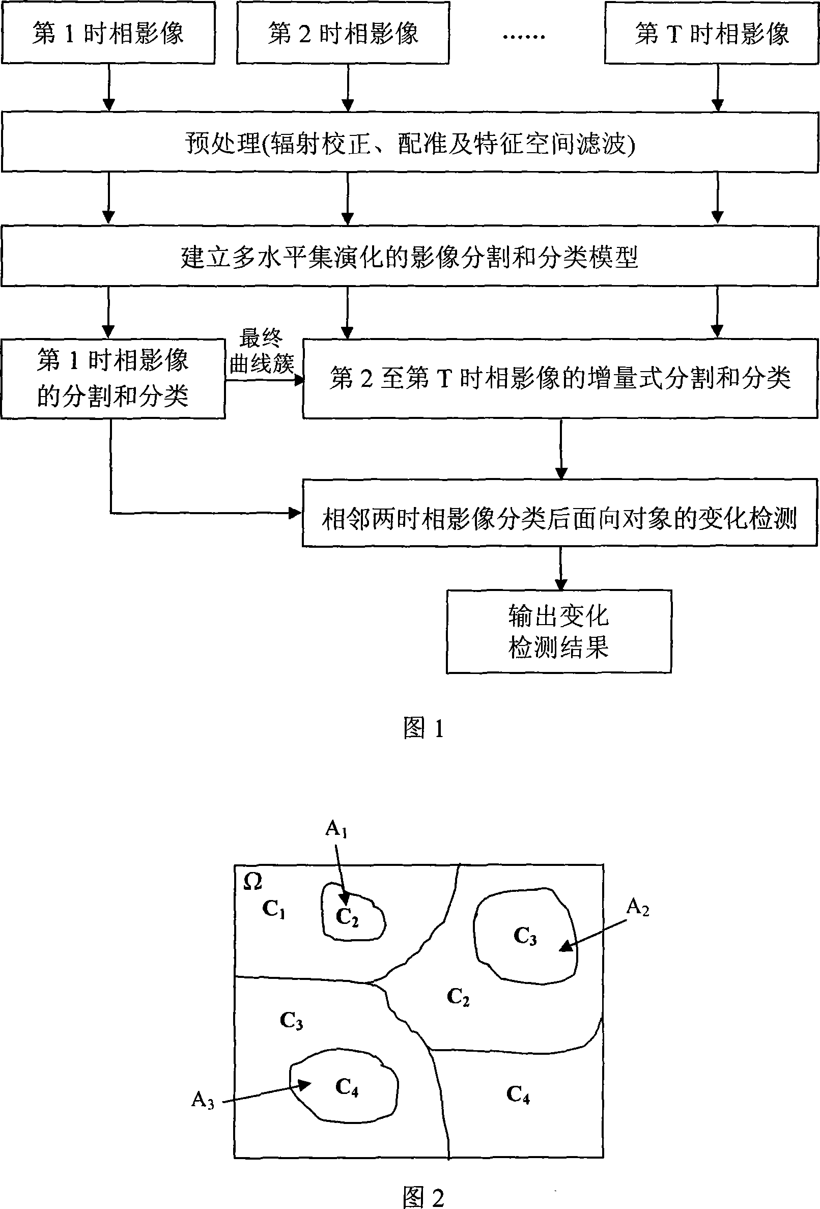
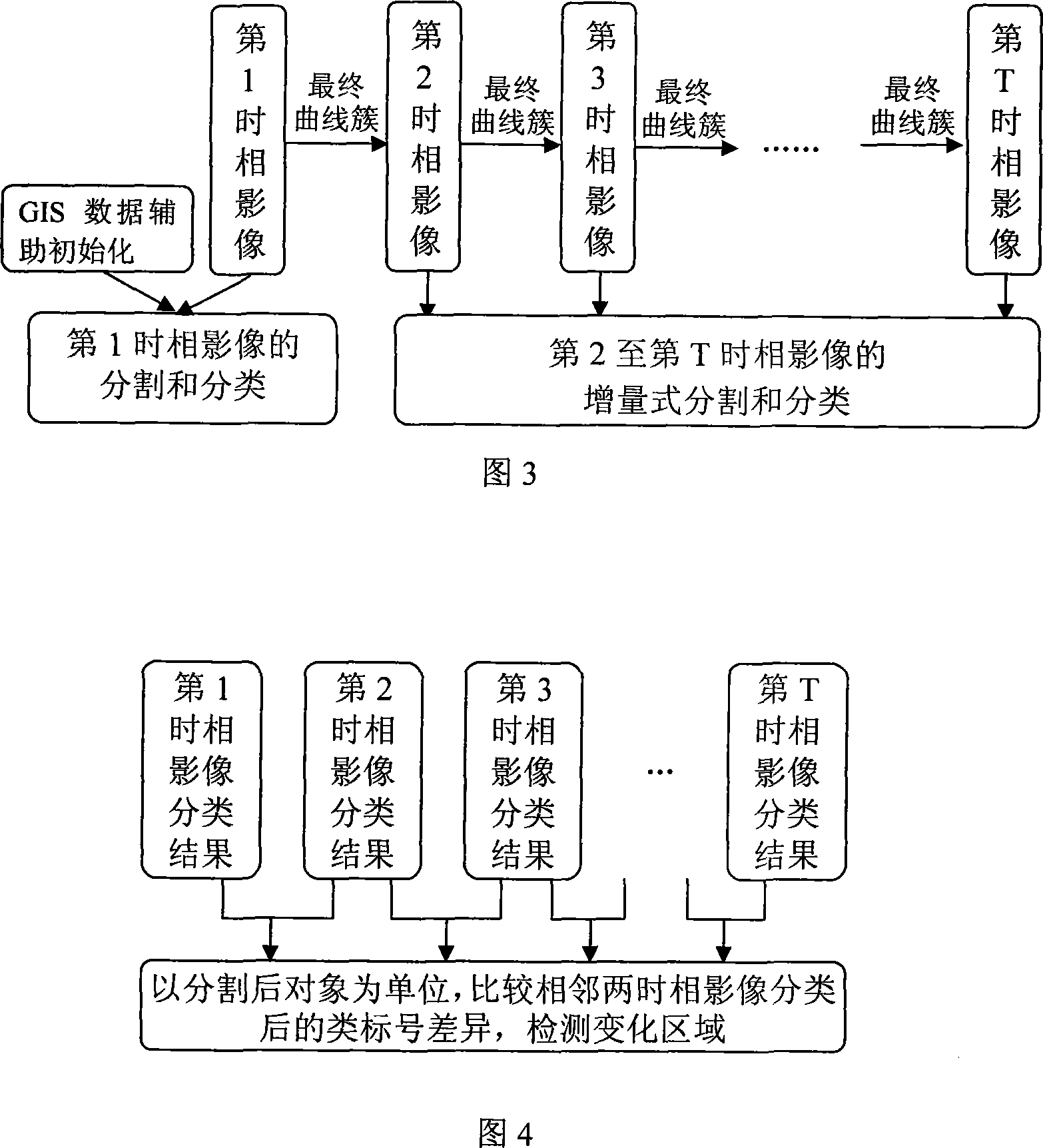
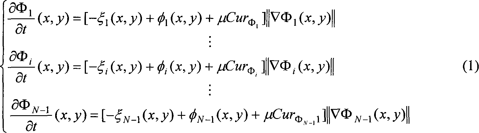
[0056] Referring to FIG. 1 , FIG. 2 , FIG. 3 and FIG. 4 , the present invention provides an integrated method for segmentation, classification and change detection based on multi-level set evolution. Assuming that the number of time phases of the image is T (T is a positive integer greater than 1), then the implementation process for the segmentation and classification and change detection of the first to T time phases is shown in Figure 1, including the following steps:

[0057] 1. Preprocessing of the original image

[0058] a) Generally, the parameters required for absolute radiometric correction are difficult to obtain. Therefore, common relative radiometric corrections are used for remote sensing images of different time phases of homogeneous sensors, such as histogram matching method, dark set-bright set method, etc. These two methods And more methods can be found in literature: Ding Lixia, Zhou Bin, Wang Renchao; Research on 5 relative radiation correction methods in re...


PUM


Abstract

The utility model discloses a integrated method based on multi-level set evolution and high resolution remote sensing image partition, classification and change inspection, which is characterized in that (1) image preprocessing (radiation, registration and filtering); (2) the multi-level set evolutional partition and classification model, after registration, the GIS data determines the initial profile of each level set function and performs the partition and classification to the first phase image; (3) the model described in the (2) is still adopted, and the initial profile of each level set function is optimized, increment type partition and classification is adopted for the second to T phase; (4) the objective after partition is used as unit, the ith and (i+1)th two adjacent phase image classification results are compared to determine the change area; (5) return back to (3) until the partition, classification and change inspection of all T phase image are finished. The utility model has the advantages that: compared with the traditional pixel-oriented K value method, the classification and inspection precision are improved, The utility model is applicable for the change inspection of sequence remote sensing image and has wide application in hazard monitoring and land resource investigation.

Description

technical field [0001] The invention belongs to the technical field of computer remote sensing image information extraction, and relates to an integrated method for segmentation, classification and change detection of high spatial resolution remote sensing images based on multi-level set surface evolution. Background technique [0002] Remote sensing image information extraction is a basic and important research content in the fields of computer and remote sensing. However, with the rapid development of sensor technology, satellite communication technology, and computer technology, remote sensing images are increasingly showing the characteristics of "three multiples", that is, multiple sensors, multiple spatial or spectral resolutions, and multiple temporal phases, which make remote sensing images automatically Information extraction is more difficult. [0003] In recent years, high spatial resolution (spatial resolution less than or equal to 5 meters, hereinafter referred...

Claims


Application Information

Patent Timeline
Patent Type & Authority Applications(China)
IPC IPC(8): G01S17/89G01S7/48
Inventor 马洪超杨耘徐宏根
Owner WUHAN UNIV
Why Eureka
Try Eureka