Method for guiding with MMS picture

A picture and MMS technology, applied in the field of navigation, can solve the problems of large map picture size, redundant information, increase the difficulty and accuracy of maps, etc., achieve good economy and convenience, improve efficiency and quality, and facilitate popularization and implementation Effect

Inactive Publication Date: 2008-07-23
汪健辉
View PDF0 Cites 1 Cited by
  • Summary
  • Abstract
  • Description
  • Claims
  • Application Information

AI Technical Summary

Problems solved by technology

At present, many map manufacturers in China have their own portals, and they can easily query bus routes and self-driving routes. Because this method requires the Internet, it is not convenient for travelers to query route information at any time.
At present, some mobile phones can query

Method used


Image

  • Method for guiding with MMS picture
  • Method for guiding with MMS picture

Examples


Embodiment Construction

[0010] The embodiment of the present invention is as follows:

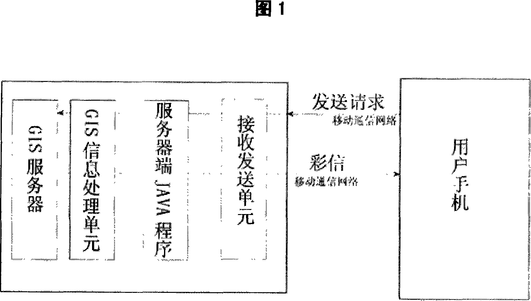
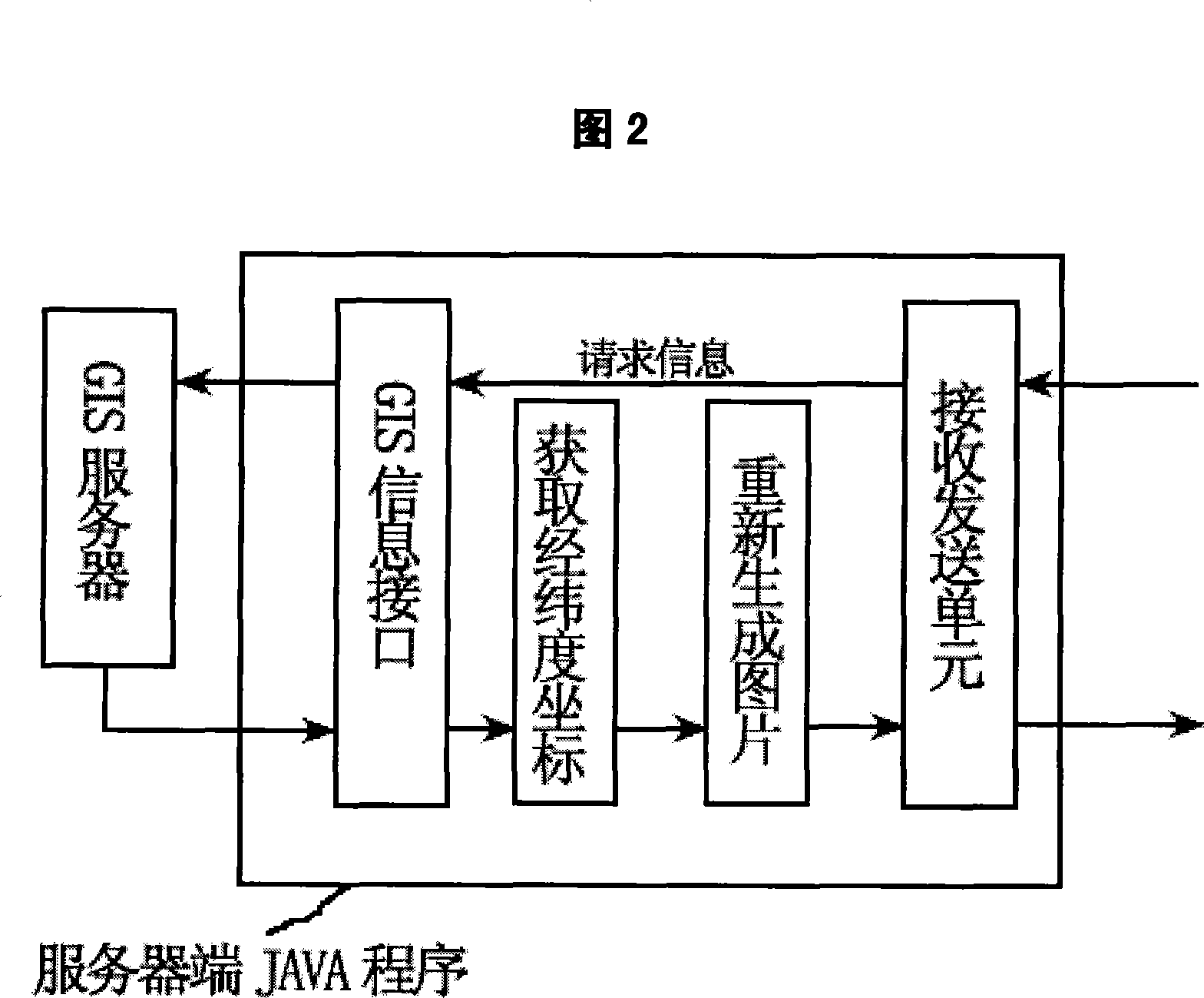
[0011] As shown in Figure 1, a method of using MMS pictures to guide the way, including a user’s mobile phone; a routing server, which includes a receiving and sending unit, a server-side JAVA program, and a GIS information processing unit; also includes a GIS server; in a mobile communication network , The user’s mobile phone sends the request information containing the names of the starting point and the end point to the routing server through SMS, voice or data communication; the receiving and sending unit of the routing server receives the request information and transmits it to the server-side JAVA program; server-side JAVA The program interacts with the GIS server through the GIS information interface, and obtains the route from the GIS server according to the names of the start and end points of the requested information, and generates a route map. Because there are more additional information in the route map,...


PUM


Abstract

A process of leading road through using multimedia pictures comprises a user cell phone, a leading road server which comprises a receiving sending unit, a server terminal JAVA program and a GIS information processing unit, and a GIS server. The user cell phone terminal sends the request information which comprises the starting point name and the end point name to the leading road server through short-messages, voice or data communication way in the mobile communication network, the receiving sending unit of the leader server receives the request information and transmits to a sever terminal JAVA program which conducts the interaction with the GIS server through a GIS information interface, and obtains the router form the GIS server according to the starting point name and end point name of the request information to produce a route chart. As the additional information of the route chart is more, which is inconvenient for users to identify the router, and is needed to extract the route to reproduce pictures according to the latitude and longitude coordinate string which comprises the route, and the leading road pictures are finally sent to the user cell phone terminal with the way of multimedia short-message through the receiving sending unit.

Description

Technical field [0001] The invention relates to a navigation technology, in particular to a method for guiding directions by using MMS. Background technique [0002] With the development of social information technology, the field of wireless communication is also constantly improving. Mobile phones used for wireless communication have become indispensable communication products in daily life, and the functions of mobile phones are constantly improving with technological innovation. Multimedia and multi-function applications of mobile phones have gradually become popular, catering to people's diversified needs for mobile phones. Among them, the use of mobile phones for navigation has also become one of people's needs for multi-functional mobile phones. [0003] China has a vast territory and vast amounts of geographic information. With the tremendous economic development, road construction in cities and villages is becoming more and more perfect, and transportation routes are bec...

Claims


Application Information

Patent Timeline
IPC IPC(8): H04Q7/22H04Q7/32G01S5/02
Inventor 汪健辉
Owner 汪健辉
Why Eureka
Try Eureka