Multisystem satellite navigation correlator

A satellite navigation and correlator technology, applied in the field of satellite navigation, can solve the problems of long time to capture satellites, unfavorable realization of high-dynamic satellite receivers, etc., and achieve the effect of saving power consumption

Inactive Publication Date: 2011-05-04
BEIHANG UNIV
View PDF7 Cites 0 Cited by
  • Summary
  • Abstract
  • Description
  • Claims
  • Application Information

AI Technical Summary

Problems solved by technology

[0011] Therefore, it takes quite a long time for the existing correlator structure to capture satellites. When the CA chip period sequence increases, such as 2046 chips, it takes a longer time to capture, which is not conducive to the realization of high dynamic satellite receivers.

Method used


Image

  • Multisystem satellite navigation correlator
  • Multisystem satellite navigation correlator
  • Multisystem satellite navigation correlator

Examples


Embodiment Construction

[0099] Specific embodiments of the present invention will be described below in conjunction with the accompanying drawings.

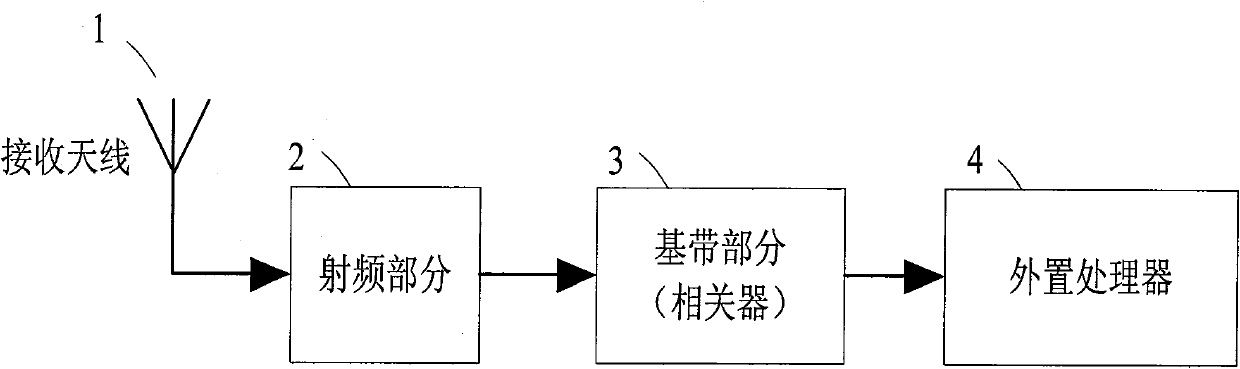
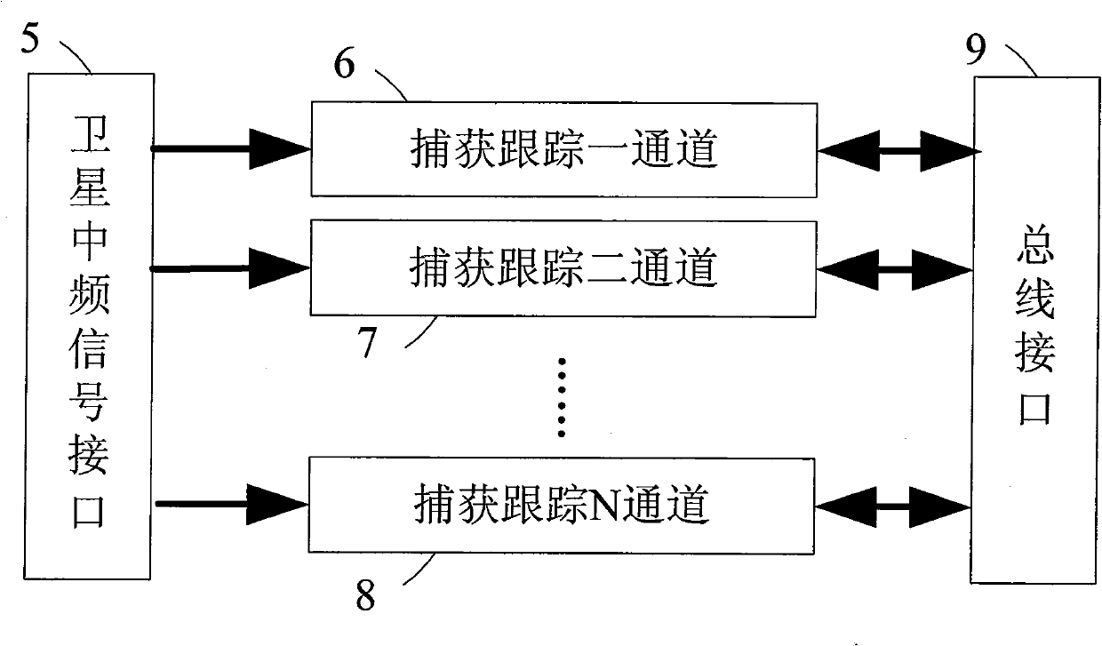
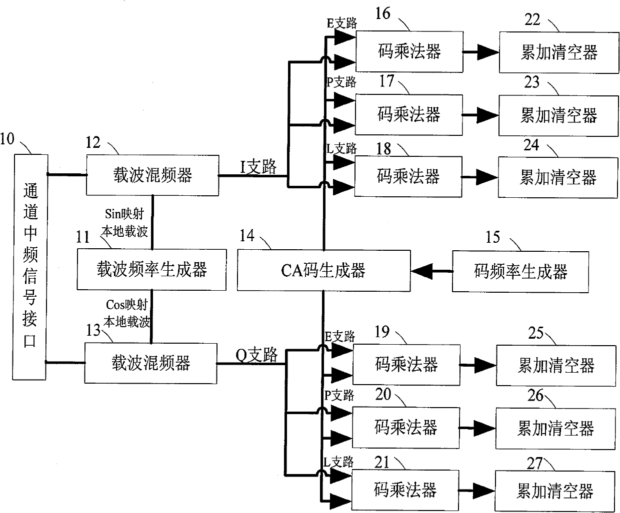
[0100] The embodiment is a correlator of a multi-system navigation receiver realized with a Field-Programmable Gate Array (Field-Programmable Gate Array, referred to as FPGA), and its overall structure is as follows Figure 4 As shown, the correlator is composed of five parts: satellite intermediate frequency signal interface 5, power controller 28, capture and track one channel 29, capture and track two channels 30, ..., capture and track N channel 31, fast capture auxiliary channel 32 and bus interface9. After the satellite intermediate frequency signal is sampled and quantized, it enters the correlator through the satellite intermediate frequency signal interface 5, and is connected to the acquisition tracking channel 29, the acquisition tracking channel 2 30, ..., the acquisition tracking N channel 31 and the fast acquisition auxiliary channel 32. ...


PUM


Abstract

The invention provides a multi-system satellite navigation correlator. The correlator is composed of a medium frequency signal interface, a bus interface, an acquisition and tracking channel, a fast acquisition and assisting channel and a power supply controller. Programmable CA code generators in the acquisition and tracking channel and the fast acquisition and assisting channel enable the correlator to process signals of various satellite systems, meanwhile, the fast acquisition and assisting channel can assist the acquisition and tracking channel to finish the acquisition of satellite signals in an extreme short time, and a power supply management controller can close any needless circuit. The correlator can be utilized to process broader satellite signals and be applied to multi-system compatible receivers; can rapidly acquire satellite signals and be applied to high dynamic receivers; and can close any disengaged circuit and save power consumption.

Description

technical field [0001] The invention relates to a multi-system satellite navigation correlator, which belongs to the field of satellite navigation. Background technique [0002] At present, the Global Navigation Satellite System (GNSS for short) has become one of the fastest-growing information industries in the world, with the characteristics of global (land, ocean, aviation and aerospace), all-weather, continuity and real-time , can provide users with services such as positioning, speed measurement and timing. Since the global satellite navigation and positioning system plays an increasingly important role in both civilian and military applications, more and more satellite positioning systems will be designed, built and used. [0003] The global satellite navigation and positioning system is the second generation of satellite navigation and positioning systems. At present, the two major satellite positioning systems are the GPS system of the United States and the GLONASS ...

Claims


Application Information

Patent Timeline
Patent Type & Authority Patents(China)
IPC IPC(8): G01S1/02G01S1/04G01S5/02G01S19/29G01S19/30G01S19/34
Inventor 张晓林张强张展苏琳琳张帅
Owner BEIHANG UNIV
Why Eureka
Try Eureka