System for providing local mobile geographic information service based on GPS and mobile terminal

A geographic information service and mobile terminal technology, which is applied in the system field of providing local mobile geographic information services based on GPS and mobile terminals, can solve the problems of reducing mobile terminal interaction and being unable to provide geospatial location information services, etc., and achieve query related information The effect of speeding up the time, convenient inquiry and low cost

Inactive Publication Date: 2009-01-14
方圆信通科技(北京)有限公司
View PDF0 Cites 90 Cited by
  • Summary
  • Abstract
  • Description
  • Claims
  • Application Information

AI Technical Summary

Problems solved by technology

[0006] In view of this, the purpose of the present invention is to provide a system that can solve the above-mentioned defects of the prior art, provide local mobile geographic information services based on GPS and mobile terminals, and this system can provide most of the services of GIS locally, that is, Realized on the mobi...

Method used


Image

  • System for providing local mobile geographic information service based on GPS and mobile terminal
  • System for providing local mobile geographic information service based on GPS and mobile terminal
  • System for providing local mobile geographic information service based on GPS and mobile terminal

Examples


Embodiment Construction

[0025] In order to make the object, technical solution and advantages of the present invention clearer, the present invention will be further described in detail below in conjunction with the accompanying drawings.

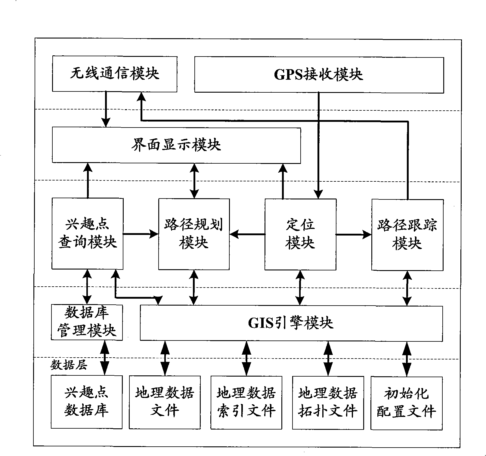
[0026] The system that the present invention provides local mobile geographical information service based on GPS and mobile terminal is composed of wireless communication network and GPS positioning device, Internet and path tracking server, and smart phones, handheld It consists of a personal computer, a personal digital assistant PDA, or a mobile communication terminal with graphic input, processing, and display functions. The communication network and related network elements are all existing equipment, and the key is to add multiple devices to the mobile terminal. Software function modules (see figure 1 ): wireless communication module, GPS receiving module, interface display module, POI query module, path planning module, positioning module, path tracking mod...


PUM


Abstract

The invention relates to a system to provide local mobile geographic information service based on GPS and mobile terminal. The system comprises: a wireless communication network, a GPS position apparatus and mobile terminal, and an internet and path tracking server. The innovation of the invention is adding the following software functional modules in the mobile terminal: a wireless communication module, a GPS receiving module, an interface displaying module, an interest point inquiring module, a path planning module, a positioning module, a path tracking module, a GIS engine module, a database management module and a data layer made up of an interest point database, a geographic data file, a geographic data index file, a geographic data topological file and a initialization configuration file. The system achieves the advantages of simple, practical, smart in data layer design, convenient in inquiring, low in cost and easy to implement. For storing geographic space data and integrating many software functional modules in the mobile terminal, the system in the invention enable the user to enjoy localized real time geographic space position service conveniently at any moment with less dependence on the server.

Description

technical field [0001] The present invention relates to a communication system for providing geographic information services, to be more precise, relates to a system for providing local mobile geographic location information services (LBS, Location Based Service) using GPS and mobile terminals. Using this system, you can choose to consult, Displaying a local map and performing zoom processing on the map, as well as realizing functions such as positioning, querying points of interest, navigation and path tracking, belong to the technical fields of telecommunication value-added services and computer applications. Background technique [0002] With the advent of the era of knowledge economy, information has become the source of wealth for human society. At present, more than 80% of the information in people's production and life is related to geographic spatial location. The rapid development and wide application of information science and technology have led to the demand of ...

Claims


Application Information

Patent Timeline
IPC IPC(8): H04Q7/38H04L12/28G01C21/26G01C21/34G06F17/30
Inventor 谢东亮陈正东佟双熊鹏李建林吴金宇王璐
Owner 方圆信通科技(北京)有限公司
Why Eureka
Try Eureka