Ionospheric layer grid regulation method suitable for multi-module satellite navigation system

A technology of a navigation system and a correction method, which is applied in the field of satellite navigation and can solve problems such as insufficient number of penetration points

Inactive Publication Date: 2009-07-22
BEIHANG UNIV
View PDF0 Cites 20 Cited by
  • Summary
  • Abstract
  • Description
  • Claims
  • Application Information

AI Technical Summary

Problems solved by technology

[0005] In order to solve the limitation of the ionospheric grid correction method due to the insufficient number of penetration points when a single satellite navigation system exists, the present invention proposes an ionospheric grid correction method suitable for multi-mode satellite navigation systems

Method used


Image

  • Ionospheric layer grid regulation method suitable for multi-module satellite navigation system
  • Ionospheric layer grid regulation method suitable for multi-module satellite navigation system
  • Ionospheric layer grid regulation method suitable for multi-module satellite navigation system

Examples


Embodiment

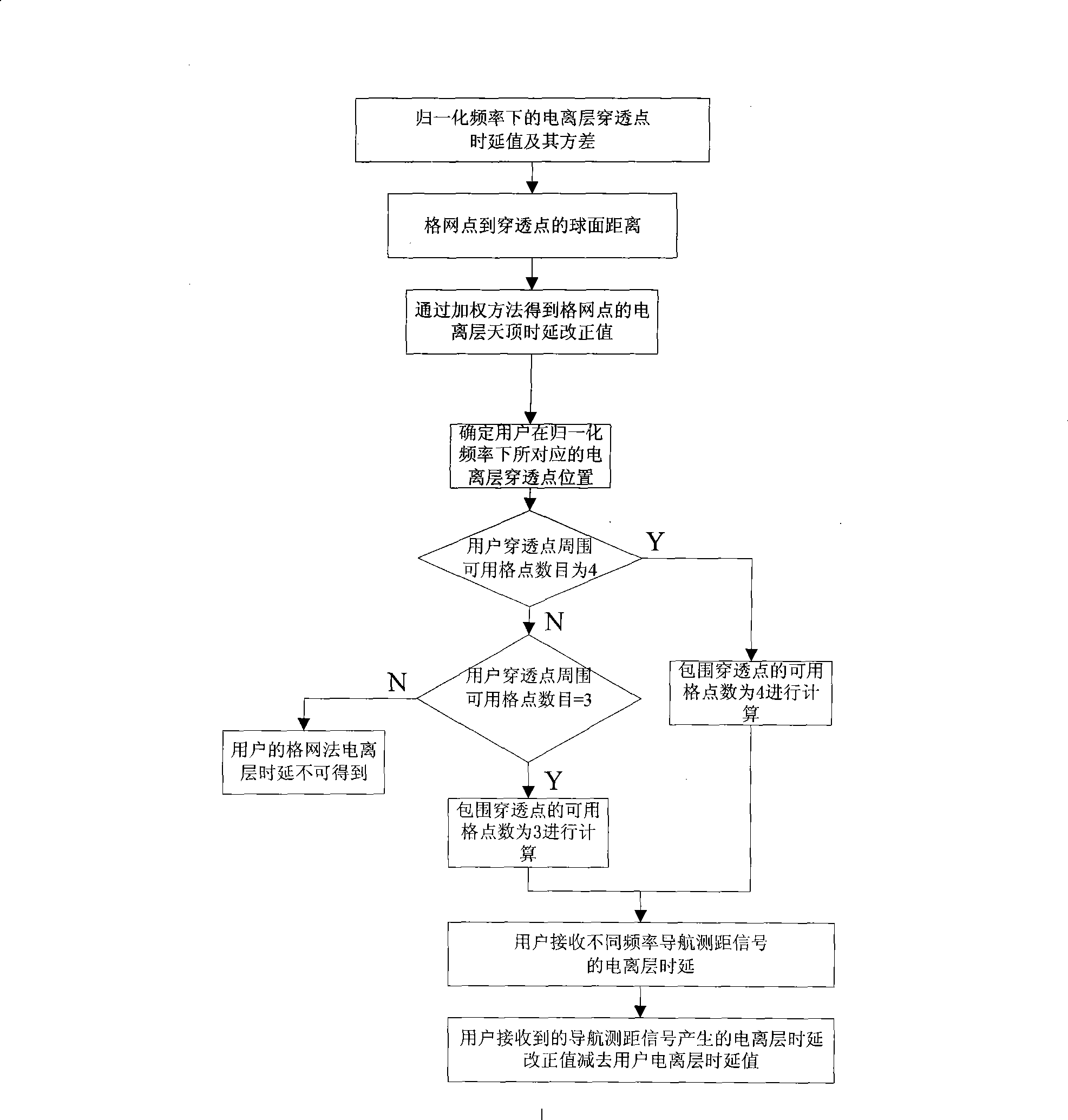
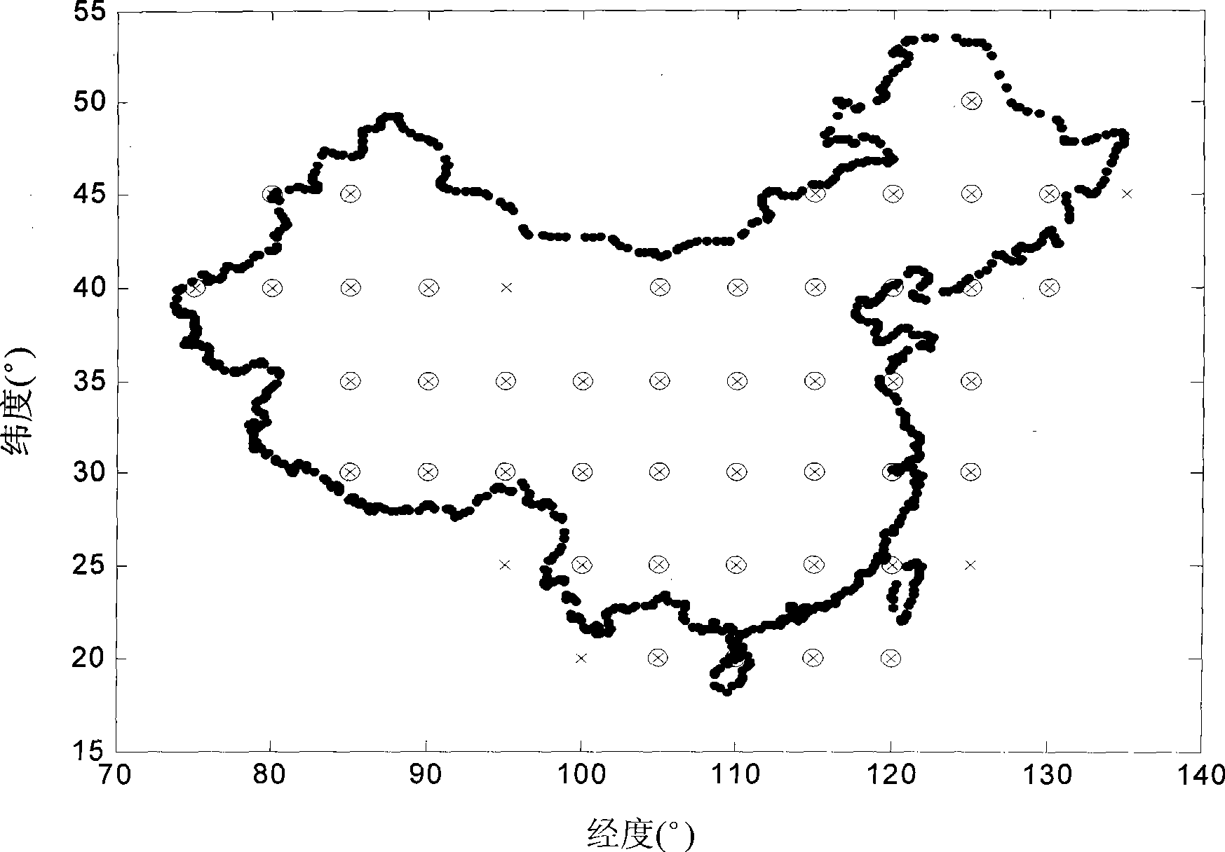
[0047] It is known that wide-area monitoring stations receive signals from GPS and Beidou (BD) satellite systems. The latitude and longitude grid distribution in China is 5°×5°. The frequency between GPS satellites and wide-area monitoring stations is f 1 The upper ionospheric delay correction value is Variance is The frequency f between the Beidou satellite and the wide-area monitoring station 2 The ionospheric delay correction on Variance is Calculate the ionospheric delay value for users in China.

[0048] Step 1: Determine the satellite navigation system for observation, and normalize the ionospheric delay correction value and its variance to the specified frequency.

[0049] Normalized frequency f = f 1 ionospheric delay correction I uni , 1 j = I 1 j , ...


PUM


Abstract

The invention discloses a method for correcting an ionospheric grid which is applied to a multimode satellite navigation system, comprising the following steps: according to data from different satellite navigation systems, normalizing the time delay correction value of the ionosphere and the variance thereof to a specified frequency; according to the normalized time delay value and variance of the breakthrough point of the ionosphere, carrying out weighing calculation respectively to determine the time delay correction value of the ionosphere zenith of the grid point in the specified frequency; utilizing the time delay correction value of the ionosphere zenith of the grid point to carry out interpolation, and determining the time delay correction value of the zenith ionosphere of the satellite ranging signals received by a user in the normalized frequency; finally determining the ionosphere time delay correction value when navigation and ranging signals with different frequencies are received by the user; and deducting user ionosphere time delay value from the ionosphere time delay correction value generated by the navigation and ranging signals received by the user to obtain the user ionosphere delay time value after elimination. By adopting the method, errors of ionosphere time delay correction are reduced, correction precision of the ionospheric grid is improved and location precision of the user can be greatly improved when the pseudo-range value of the user is used for location calculation.

Description

technical field [0001] The invention belongs to the field of satellite navigation, and specifically refers to an ionospheric grid correction method suitable for a multi-mode satellite navigation system. Background technique [0002] One of the main sources of error in satellite navigation and positioning systems is the ionospheric delay of radio wave propagation. The vast majority of C / A code receiver users can only correct about 50% of the ionospheric errors using the Kloubuchar model parameter method of satellite broadcasting. [0003] The Wide Area Augmentation System (WAAS) proposed by the Federal Aviation Administration (FAA) uses a grid correction method to provide real-time, large-scale and accurate ionospheric correction for single-frequency users. This correction method divides the longitude and latitude lines on the ionospheric reference surface (usually 350-400 km) in the region into grids at intervals of 5 degrees. According to the real-time and accurate ionosp...

Claims


Application Information

Patent Timeline
Patent Type & Authority Applications(China)
IPC IPC(8): G01S1/02G01S5/14
Inventor 李锐汪珊朱衍波张军
Owner BEIHANG UNIV
Why Eureka
Try Eureka