Method for extracting roads from remote sensing image based on non-sub-sampled contourlet transform

A non-subsampling contour and remote sensing image technology, applied in the field of image processing, to achieve the effects of improving efficiency, robust detection results, and fast computing speed

Inactive Publication Date: 2009-10-07
XIDIAN UNIV
View PDF0 Cites 32 Cited by
  • Summary
  • Abstract
  • Description
  • Claims
  • Application Information

AI Technical Summary

Problems solved by technology

However, it is still a challenge to use the non-subsampled contourlet transform well for road extraction, and there is no related technology for using this transform for road extraction in remote sensing images

Method used


Image

  • Method for extracting roads from remote sensing image based on non-sub-sampled contourlet transform
  • Method for extracting roads from remote sensing image based on non-sub-sampled contourlet transform
  • Method for extracting roads from remote sensing image based on non-sub-sampled contourlet transform

Examples


Embodiment Construction

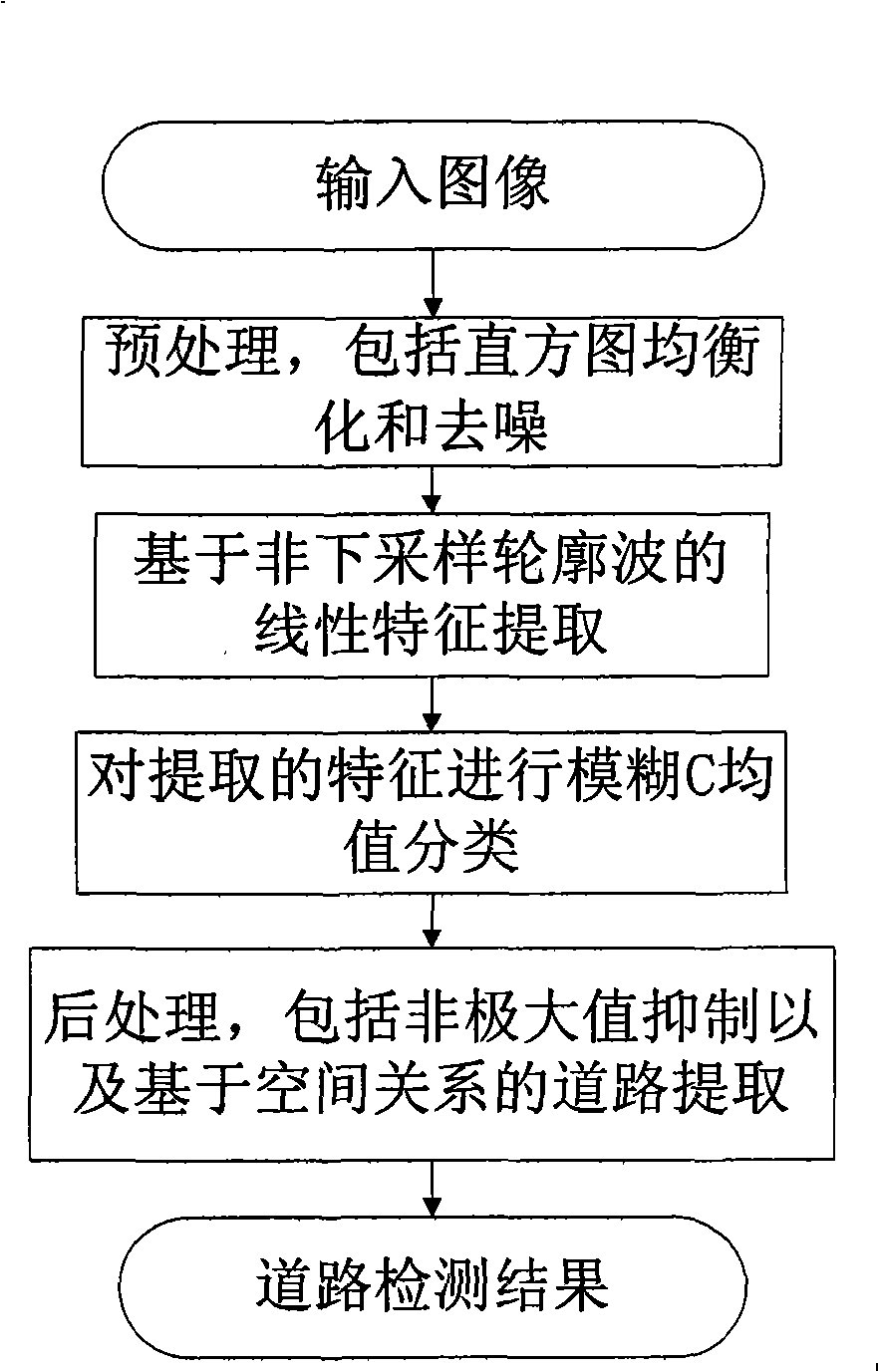
[0031] refer to figure 1 , the implementation of the present invention is as follows:

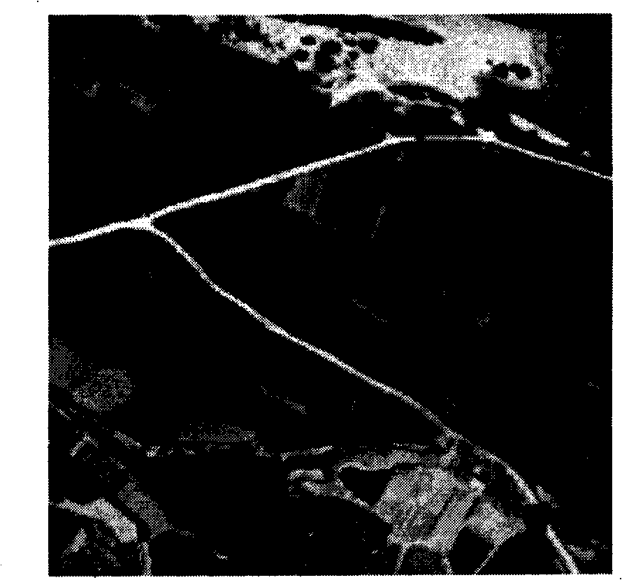
[0032] Step 1, preprocessing the input image X. Preprocessing includes Frost and adaptive histogram equalization, respectively as image 3 and Figure 4 shown.

[0033] Step 2, transform the preprocessed image.

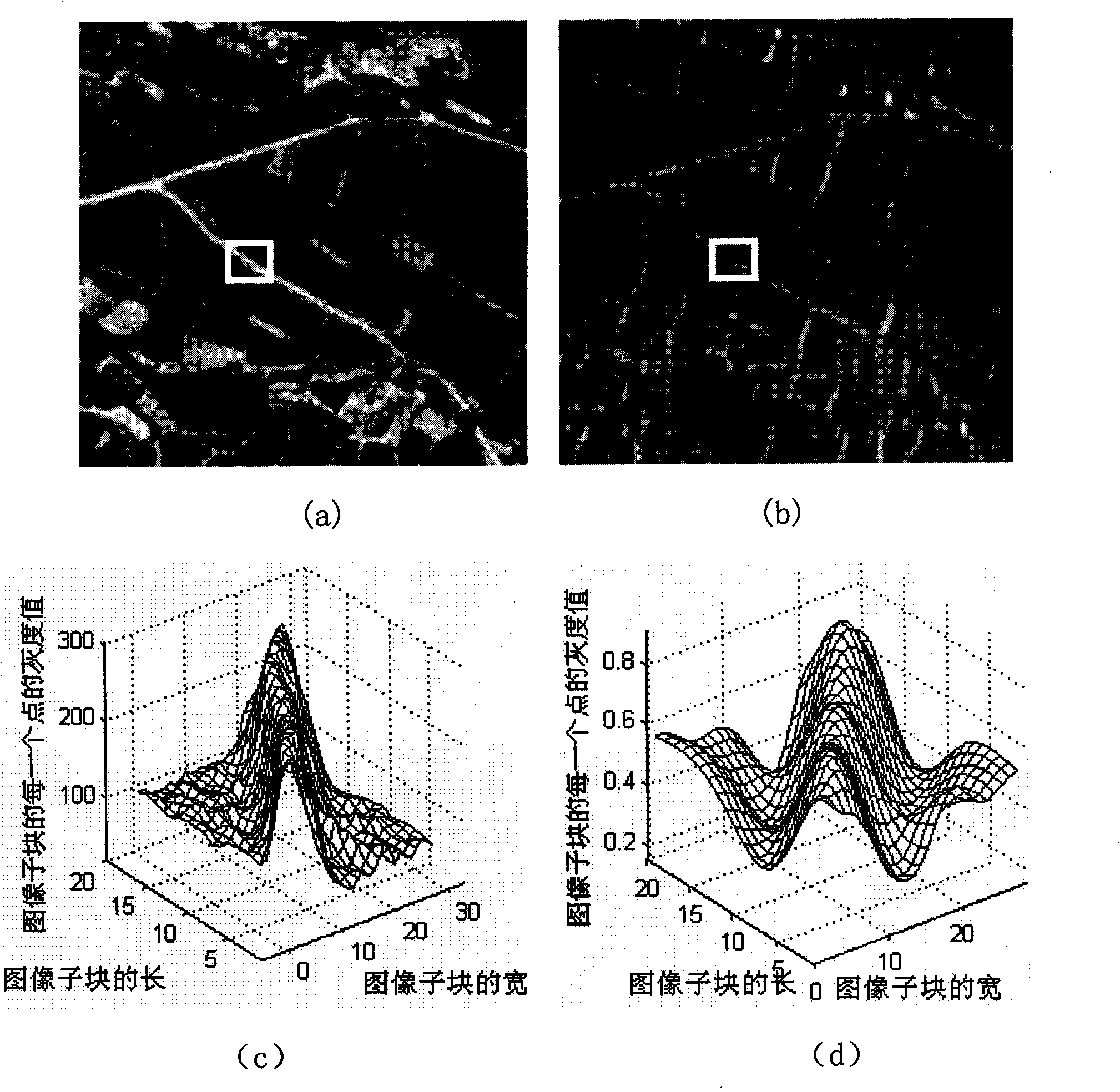
[0034] (2a) Carry out K scale non-subsampling contourlet transforms to the preprocessed image, this example takes K=3, each scale transformation is divided into D directions, this example takes D=8; and the preprocessed image The graph is compared with the three-dimensional coefficients of the transformed graph, such as figure 2 (c) and 2(d). in figure 2 (a) is the preprocessed image, figure 2 (b) is figure 2 (a) After the transformation, the coefficient map of a certain direction on the second layer, figure 2 (c) is figure 2 (a) The three-dimensional coefficient map inside the white box, figure 2 (d) is figure 2 (b) The three-dimensional coefficient map in the...


PUM


Abstract

The invention discloses a method for extracting roads from a remote sensing image, which belongs to the technical field of image processing and solves the problem that the existing technology is not precise in detection and positioning of roads, and has a large number of false targets and bad continuity. The specific realization process comprises the following steps of: firstly implementing pretreatments including adaptive histogram equalization and Frost de-noising on the input images; then implementing three layers of non-sub-sampled contourlet transform thereon, decomposing each layer into eight directions, extracting the model maximum value of each direction sub-band of the first layer and the second layer as the linear characteristic vectors of roads; clustering the obtained characteristic vectors by using fuzzy C means clustering algorithm to obtain the initial extraction results of roads; and finally implementing non maximum value inhibition and road post treatment based on the spatial relationship to the initial extraction to obtain the final road extraction result. The invention has the advantages of accurate road positioning, good integrality, low calculation complexity and no need of training and learning, and is used for analysis and processing of the remote sensing image.

Description

technical field [0001] The invention belongs to the technical field of image processing and relates to image target detection, in particular to a remote sensing image road extraction method, which is suitable for remote sensing image analysis and processing. Background technique [0002] The rapid development of space technology and information technology has provided us with a large amount of remote sensing data, and obtaining target information from remote sensing images has become an important means of spatial information update at this stage. Therefore, how to intelligently interpret massive remote sensing data has become an important issue in the process of informatization construction. As one of the research hotspots, the extraction of roads has been widely concerned, and has very important theoretical and practical significance in the fields of national economic production and military target reconnaissance. Remote sensing image road extraction is an important conten...

Claims


Application Information

Patent Timeline
Patent Type & Authority Applications(China)
IPC IPC(8): G06K9/46G01C11/04
Inventor 钟桦焦李成冯颖涛王爽侯彪缑水平杨淑媛张晓华王桂婷
Owner XIDIAN UNIV
Why Eureka
Try Eureka