Positioning and directional digital geological compass with low cost, high precision and high integration

A high-integration, positioning-oriented technology, applied in compass, positioning, measuring angle and other directions, can solve the problems of low measurement accuracy, cumbersome measurement steps, and the measurement data is not digitized, so as to maintain high accuracy and integration. High, lower cost and power consumption

Inactive Publication Date: 2009-10-28
DEV RES CENT OF CHINA GEOLOGICAL SURVEY
View PDF0 Cites 15 Cited by
  • Summary
  • Abstract
  • Description
  • Claims
  • Application Information

AI Technical Summary

Problems solved by technology

[0040] The technical problem to be solved by the present invention is that the existing geological compass has not realized the integration of orientation and positioning measurement, the measurement a

Method used


Image

  • Positioning and directional digital geological compass with low cost, high precision and high integration
  • Positioning and directional digital geological compass with low cost, high precision and high integration
  • Positioning and directional digital geological compass with low cost, high precision and high integration

Examples


Embodiment Construction

[0068] The present invention will be further described below in conjunction with the accompanying drawings and specific embodiments, so that those skilled in the art can better understand the present invention and implement it, but the examples given are not intended to limit the present invention.

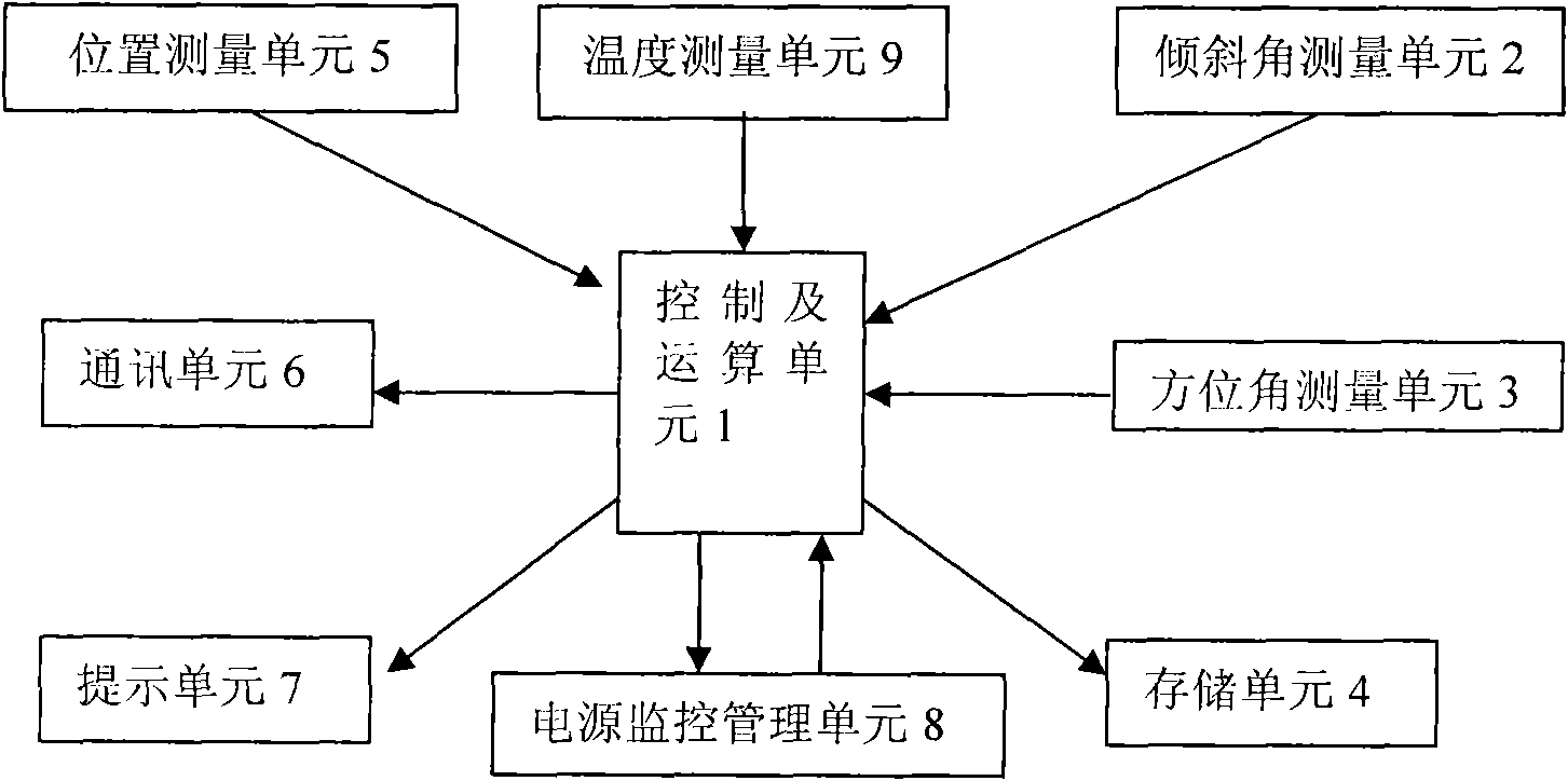
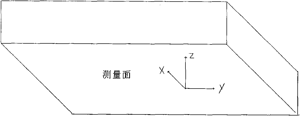
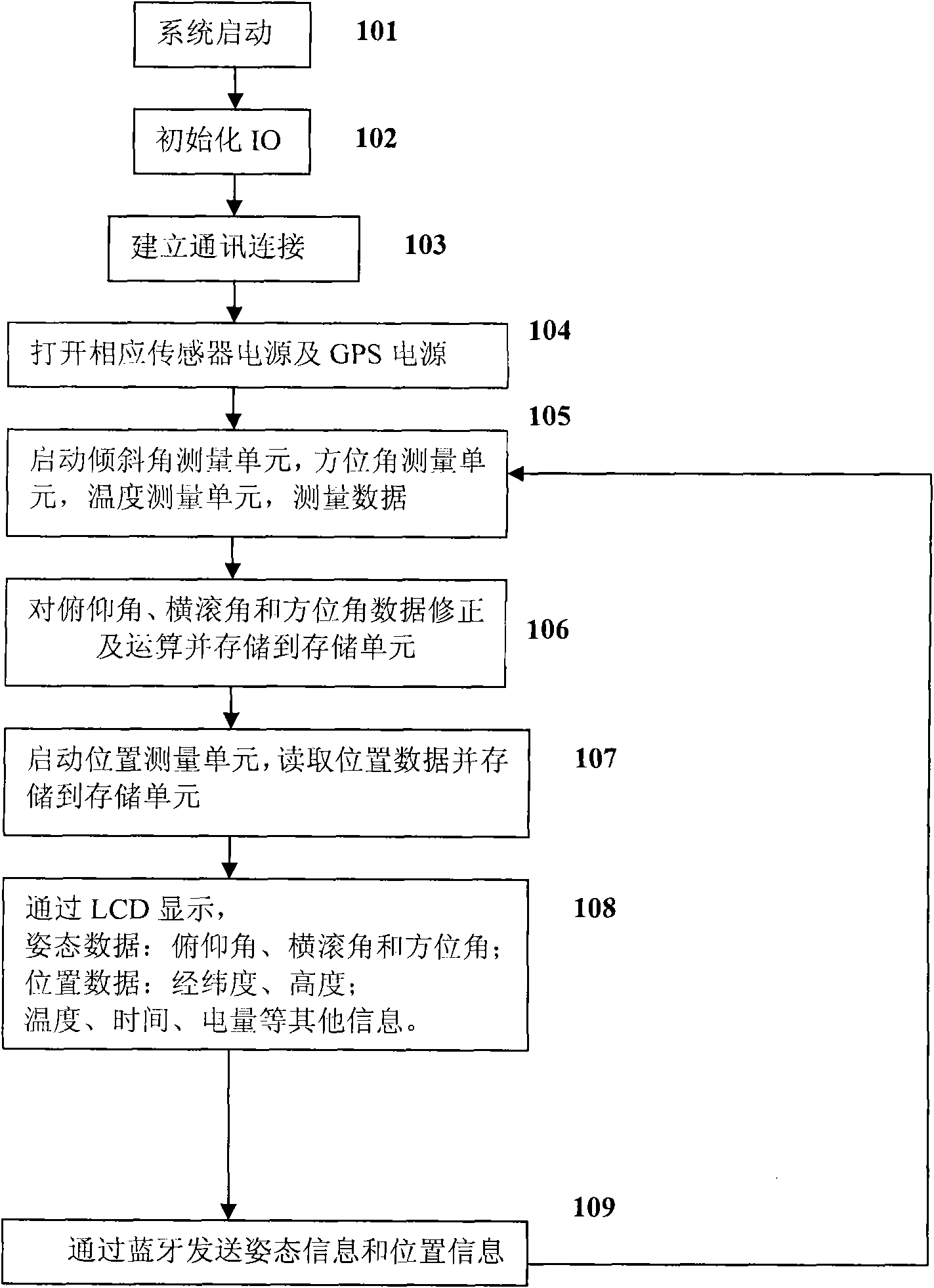
[0069] Compared with the mechanical geological compass, when measuring the occurrence, you only need to place the digital geological compass of the present invention on the measuring surface, and one measurement can obtain: trend, inclination, inclination and current geographic coordinates (Gauss) X, Y, elevation, And the mechanical geological compass needs 4 steps to accomplish; When measuring the profile, after directly aligning the two ends (middle line) of the digital geological compass sight of the present invention with the measured target with eyes, a measurement can obtain: current geographic coordinates ( Gauss) X, Y, elevation, general direction (ie strike) and slope (ie ...


PUM


Abstract

The invention discloses a positioning and directional digital geological compass with low cost, high precision and high integration, comprising an inclined angle measuring unit, an azimuth angle measuring unit, a temperature measuring unit, a control and operation unit, a prompt unit and a storage unit; and the control and operation unit is connected with all other units. The compass also comprises a position measuring unit which is connected with the control and operation unit and is used for obtaining the position data of latitude and longitude, satellite time and height position and providing the data to the control and operation unit. The control and operation unit comprises 51 signal chip microcomputers, an interface simulation module, a background timer interruption service module and a foreground processing module. The positioning and directional digital geological compass does not need to hold by hand when in measurement, can measure the elevation angle, the roll angle, the azimuth angle and the position at one time only by being arranged on the object to be measured, i.e., the geological compass (directional measurement) and directional measurement (such as GPS) are integrated into one device, but high precision, low cost and low power consumption are ensured.

Description

technical field [0001] The invention relates to the field of geological survey devices, in particular to a digital compass used for measuring position, orientation, occurrence, slope and aspect in geological survey. Background technique [0002] Regional geological survey is a basic, public welfare and comprehensive geological survey and research work, and it is the first step of all geological work, and its work involves almost all fields of geosciences. Regional geological survey results are one of the important basic tasks for national economic construction and social development, and are the basis and basis for various geological work such as mineral geology, hydrogeology, engineering geology, disaster geology, environmental geology and geoscience research. [0003] The traditional regional geological survey is through the continuous observation of geological routes (visual topographic maps) in the field by geological personnel and the use of tools such as hammers, compa...

Claims


Application Information

Patent Timeline
IPC IPC(8): G01C17/00G01C9/00G01C1/00G01S5/02
Inventor 李超岭沙洲沙岩刘畅
Owner DEV RES CENT OF CHINA GEOLOGICAL SURVEY
Why Eureka
Try Eureka