Subaqueous multi-cable positioning system and method thereof.

A positioning system and positioning method technology, applied in positioning, radio wave measurement system, beacon system using ultrasonic/sonic/infrasonic waves, etc. The effect of shortening positioning cycle, improving positioning accuracy and reducing time

Active Publication Date: 2010-03-31
嘉兴中科声学科技有限公司
View PDF0 Cites 30 Cited by
  • Summary
  • Abstract
  • Description
  • Claims
  • Application Information

AI Technical Summary

Problems solved by technology

There are many positioning devices used, the operation is complicated, and the role of certain positioning methods is not fully utilized

Method used


Image

  • Subaqueous multi-cable positioning system and method thereof.
  • Subaqueous multi-cable positioning system and method thereof.
  • Subaqueous multi-cable positioning system and method thereof.

Examples


Embodiment Construction

[0063] The present invention will be described in further detail below in conjunction with the accompanying drawings and embodiments, but the present invention is not limited to these embodiments.

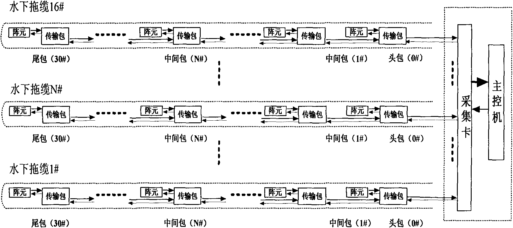
[0064] figure 1 It is a schematic diagram of the structure of the multi-cable positioning system. The multi-cable positioning system is composed of a surface tugboat and an underwater tow cable. The data transmission system composed of depth gauge, compass array element and data transmission package. Corresponding to each array element in the towline, the data transmission package is installed separately, which is responsible for transmitting the command sent by the main control machine to each array element, and transmitting the positioning information collected by each array element to the ship and sending it to the main control machine for processing through the data acquisition card .

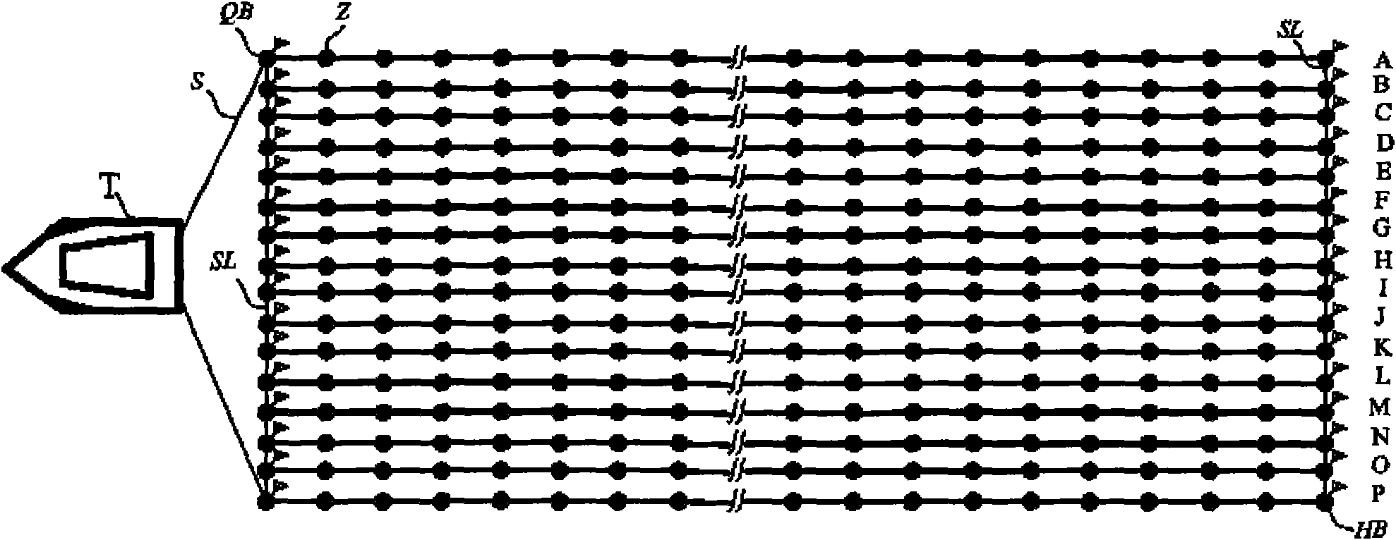
[0065] figure 2 In the schematic diagram of multi-cable positioning array element layout...


PUM


Abstract

The invention relates to a subaqueous multi-cable positioning system and a method thereof. The system comprises a data collection card, a main control machine and a plurality of dragging cables, wherein the data collection card and the main control machine are positioned on a water surface cable dragging ship, and the dragging cables are dragged by the cable dragging ship. Array elements comprising an acoustic energy transducer, a bathometer and a compass and a data transmission system comprising a data transmission packet are arranged in the dragging cables. The main control machine transmitsa positioning command to each array element, the array elements measure the required positioning information, and the main control machine resolves each section of concrete position of the dragging cables. The invention adopts the hydroacoustic positioning of an optimized acoustic array and combines a GPS drogue, the compass and the bathometer to position a plurality of cables. The method comprises the following steps: firstly, determining the geodetic coordinates of the front end and the back end of each dragging cable by a GPS; measuring the depth information of each section of the draggingcables by the bathometer, resolving the transverse and longitudinal coordinates of each section on the dragging cables relative to the navigation direction of the dragging ship by acoustic positioning primarily and retaining the value of the transverse coordinates; and recalculating the longitudinal coordinates of each section on the dragging cables by the value of the transverse coordinates obtained by compass data and acoustic positioning.

Description

technical field [0001] The invention belongs to the field of marine seismic exploration, and in particular relates to a positioning system and a method for a plurality of streamers towed by a marine seismic exploration tugboat. Background technique [0002] The exploration, development and utilization of marine oil and gas resources and deep-sea mineral resources have attracted the attention of countries all over the world. To realize the development and utilization of marine oil and gas resources and deep-sea mineral resources, it is necessary to develop marine resource exploration technology. With the continuous improvement of science and technology, offshore oil exploration technology is developing in the direction of high precision and high resolution, in order to find thinner layers and smaller oil and gas structures. [0003] Seismic method is by far the most effective oil and gas exploration method. In order to reduce costs and improve efficiency, the trend of seism...

Claims


Application Information

Patent Timeline
Patent Type & Authority Applications(China)
IPC IPC(8): G01V1/38G01S1/72G01S5/30
Inventor 冯海泓黄敏燕李国栋高杰徐海东
Owner 嘉兴中科声学科技有限公司
Why Eureka
Try Eureka