Intelligent method for classifying high-resolution remote sensing images

A remote sensing image, high-resolution technology, applied in image analysis, image data processing, instruments, etc., can solve problems such as stretched, weakened image randomness, misclassification, etc., achieving simple principles, solving over-segmentation problems, and fast computing speed. Effect

Active Publication Date: 2010-05-19
CENT FOR EARTH OBSERVATION & DIGITAL EARTH CHINESE ACADEMY OF SCI
View PDF0 Cites 32 Cited by
  • Summary
  • Abstract
  • Description
  • Claims
  • Application Information

AI Technical Summary

Problems solved by technology

The traditional image classification technology studies the classification technology of low-resolution remote sensing images with a large number of mixed pixels. The pixel features extracted by this technology are relatively simple, and only contain the information of the image spectrum.
With the improvement of spatial resolution of remote sensing images, remote sensing images have a very clear structure, and image pixels are no longer the basic unit of imag

Method used


Image

  • Intelligent method for classifying high-resolution remote sensing images
  • Intelligent method for classifying high-resolution remote sensing images
  • Intelligent method for classifying high-resolution remote sensing images

Examples


Embodiment Construction

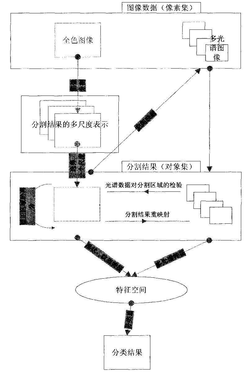
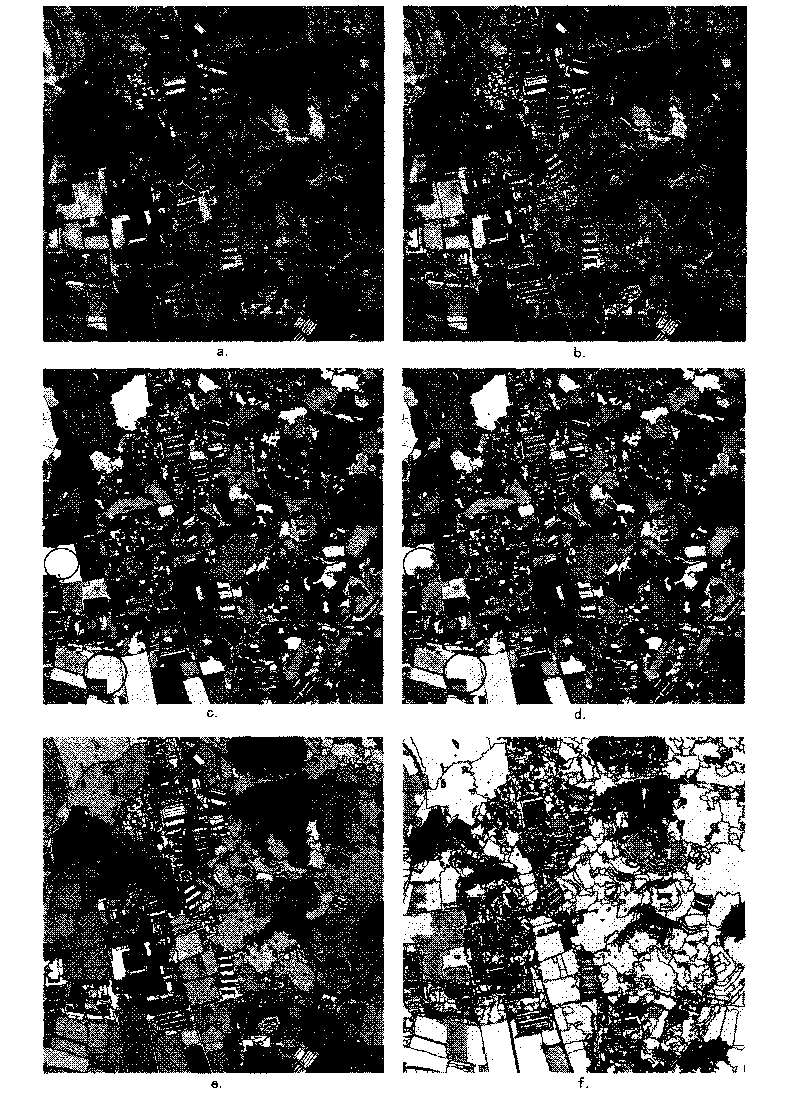
[0052] Figure 2 is The high spatial resolution remote sensing image classification result obtained by the method of the invention.

[0053] The experiment intercepted the image data with the full-color image size of 1024×1024.

[0054] Figure a is the intercepted full-color image, and Figure b is the result of image segmentation. It can be seen from the fused image that the result of image segmentation is under-segmented.

[0055] Figure c is the resulting image where the segmented regions are given different colors. Here, the "circle" is used to mark the visually under-segmented area, and the under-segmented situation can be clearly seen from the fused image.

[0056] Figure d is the result map after the under-segmentation region is subdivided. It can be seen that the four under-segmented areas that are more obvious in Figure c have been accurately subdivided in Figure d.

[0057] Figure e is the image after the final segmented region is endowed with multispectral featu...


PUM


Abstract

In view of the characteristics of the high-resolution remote sensing images, the invention provides a practical intelligent method for classifying images, which comprises the following six steps: generating the image segmentation result of a full-color image; acquiring the segmentation result of a multispectral image by utilizing space mapping; determining whether the segmented regions of the full-colour image are insufficiently segmented; resegmenting the detected insufficiently-segmented region; generating the regional feature space; and classifying the image by using a classifier. The invention solves the problem that the insufficiently-segmented regions frequently influence the image classification precision in the image classification process. The method is suitable for high-resolution images from remote sensing satellites, such as IKONOS, QUICKBID and the like, and plays an important role in extracting application messages, such as target identification, resource environment survey, land utilization trends, disaster monitoring, disaster situation evaluation and the like.

Description

technical field [0001] The invention is a practical intelligent classification method for high-resolution remote sensing images, which is suitable for high-spatial-resolution satellite remote sensing images such as IKONOS and QUICKBIRD, and is widely used in the research and development of target identification, resource and environment investigation, land use dynamics, disaster assessment, etc. application field. Background technique [0002] The classification of remote sensing images is one of the most basic issues in the processing and application of remote sensing image information. The interpretation, analysis and geoscience applications of remote sensing data often need to be realized through the classification and processing of remote sensing images. [0003] In the development process of remote sensing image classification technology, with the development of high-resolution sensor technology, the spatial resolution of satellite remote sensing images is getting highe...

Claims


Application Information

Patent Timeline
IPC IPC(8): G06K9/62G06T7/00G01S7/48G06T7/11
Inventor 何国金袁继颖
Owner CENT FOR EARTH OBSERVATION & DIGITAL EARTH CHINESE ACADEMY OF SCI
Why Eureka
Try Eureka