Double pseudo satellite aided position calibration method of inertial navigation system

An inertial navigation system and inertial navigation system technology, applied in satellite radio beacon positioning systems, radio wave measurement systems, measurement devices, etc., can solve the problems that satellite navigation systems are susceptible to interference, etc., and achieve simple and flexible settings and improved accuracy Effect

Active Publication Date: 2010-08-04
BEIHANG UNIV
View PDF2 Cites 5 Cited by
  • Summary
  • Abstract
  • Description
  • Claims
  • Application Information

AI Technical Summary

Problems solved by technology

Therefore, the combination of inertial navigation and satellite navigation is currently the most commonly used integrated navigation method, but the biggest defect of the satellite navigation system is that it is susceptible to interference

Method used


Image

  • Double pseudo satellite aided position calibration method of inertial navigation system
  • Double pseudo satellite aided position calibration method of inertial navigation system
  • Double pseudo satellite aided position calibration method of inertial navigation system

Examples


Embodiment Construction

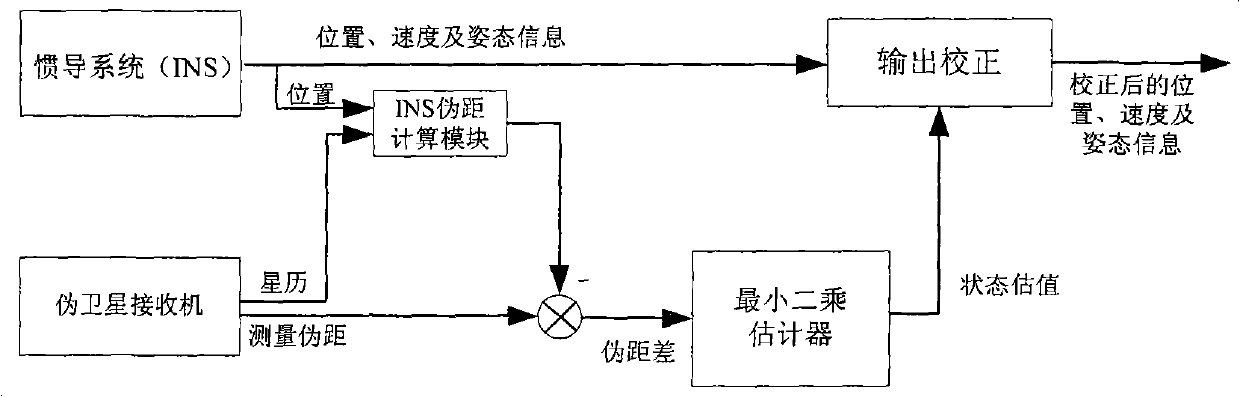
[0017] The position calibration method of the dual pseudolite-assisted inertial navigation system proposed by the present invention uses the least square method to estimate the position error of the inertial navigation system and calibrates it according to the pseudorange measurement information of the two pseudolites, thereby improving the accuracy of the inertial navigation system.

[0018] The specific implementation process of the present invention will be set forth below.

[0019] figure 1 A schematic diagram of the principle of the present invention is given. In the example, the northeast sky geographic coordinate system is used as the navigation coordinate system, considering the situation of plane positioning.

[0020] 1. Determine the variable to be requested

[0021] The variables to be estimated by the dual pseudolite-assisted inertial navigation position calibration algorithm are: the out-of-synchronization time Δτ between the inertial navigation system and the p...


PUM


Abstract

The invention relates to a method for calibrating the position error of an inertial navigation system aided by double pseudo satellites, which comprises the following steps: taking the position errors of the inertial navigation system, i.e. delta x and delta y, the out-of-sync time between the inertial navigation system and the pseudo satellites, i.e. delta tau, and the clock error of a pseudo satellite receiver, i.e. delta T0, as variables to be calculated; subtracting a calculated pseudo range from the measured pseudo range output by the pseudo satellite receiver to calculate the clock error of the pseudo satellite receiver, wherein the calculated pseudo range is the inertial navigation system-pseudo satellite distance calculated based on the output of inertial navigation system when the carrier starts to receive the signals of the two pseudo satellites; establishing a mathematical model between the difference between the measured pseudo range of the pseudo satellite receiver and the calculated pseudo range and the variables to be calculated, and using the least square method to estimate the variables to be calculated; and using the estimated state vector to calibrating the position information of the inertial navigation system, and then outputting. The invention calibrates the position errors of the inertial navigation system by using the information of the two pseudo satellites, and improves the navigation accuracy.

Description

technical field [0001] The invention relates to a method for calibrating the position error of an inertial navigation system by using two pseudolites, belonging to the technical field of navigation and positioning. Background technique [0002] The inertial navigation system (INS) has good autonomy and concealment, can continuously provide output information of various high-precision navigation parameters (position, speed, attitude, heading, etc.), and has a wide frequency band. Navigation equipment, but its errors (especially position errors) accumulate over time, and cannot undertake the task of high-precision navigation alone for a long time. The positioning and speed measurement accuracy of the satellite navigation system is high, and it is basically not restricted by region and time. Therefore, the combination of inertial navigation and satellite navigation is currently the most commonly used integrated navigation method, but the biggest defect of the satellite navigat...

Claims


Application Information

Patent Timeline
Patent Type & Authority Applications(China)
IPC IPC(8): G01C25/00G01S19/44
Inventor 王玮
Owner BEIHANG UNIV
Why Eureka
Try Eureka