Inertial navigation system measuring error correction method based on external measuring information

An inertial navigation system and measurement error technology, which is applied in the field of measurement and can solve problems such as large debugging workload, difficulty in calculating integrated navigation calculations, and convergence effects.

Active Publication Date: 2017-04-26
BEIJING INST OF AEROSPACE CONTROL DEVICES
View PDF3 Cites 2 Cited by
  • Summary
  • Abstract
  • Description
  • Claims
  • Application Information

AI Technical Summary

Problems solved by technology

When using the Kalman filter algorithm to design an integrated navigation system, it is necessary to establish a system error model. In addition, the Kalman filter algorithm is a recursive algorithm. When starting the algorithm, it is necessary to set the initial value of the parameters, the correctness of the error model and The rationality of the initial value of the parameter will have a direct impact on the convergence of the algorithm. In engineering application, it is necessary to set a reasonable initial value of the parameter for different products, and the debugging workload is very heavy.
In addition, as the frequency of external survey information increases, it will be difficult to complete the integrated navigation calculation in one cycle after using the Kalman filter.

Method used


Image

  • Inertial navigation system measuring error correction method based on external measuring information
  • Inertial navigation system measuring error correction method based on external measuring information
  • Inertial navigation system measuring error correction method based on external measuring information

Examples


Embodiment Construction

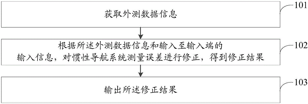
[0084] In order to make the purpose, technical solution and advantages of the present invention clearer, the following will further describe the public implementation manners of the present invention in detail with reference to the accompanying drawings.

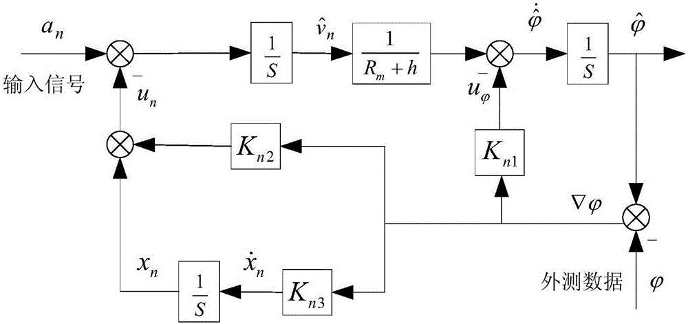
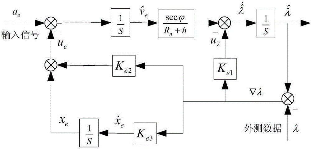
[0085]One of the core ideas of the present invention is that the integrated navigation system damping loop includes a velocity damping loop (a northward velocity damping loop, an eastward velocity damping loop, and an astronomical velocity damping loop) and a position damping loop (a latitude damping loop, a longitude damping loop, and an altitude damping loop). circuit). The basic principle of damping is that when the real position information (latitude, longitude, height) and speed information (north speed, east speed, sky speed) of the carrier are obtained, the position information (latitude, longitude, Height) and speed information (north speed, east speed, sky speed) are respectively different from the real position inf...


PUM


Abstract

The invention discloses an inertial navigation system measuring error correction method based on external measuring information. The method comprises the steps that external measuring data information is acquired, wherein the external measuring data information comprises at least one of the external measuring latitude phi, the external measuring longitude lambda and the external measuring height h; an inertial navigation system measuring error is corrected according to the external measuring data information and input information input into the input end, and correction results are obtained, wherein the input information comprises at least one of the north accelerated speed a<n>, the east accelerated speed a<e> and the uranic accelerated speed a which are determined according to an inertial navigation system; the correction results are output, wherein the correction results comprise a north channel position error correction result, an east channel position error correction result and a uranic channel position error correction result. According to the method, correction on the speed and the position of the inertial navigation system is achieved, and the robustness and the navigation precision of a combined navigation system are improved.

Description

technical field [0001] The invention belongs to the field of measurement technology, in particular to a method for correcting measurement errors of an inertial navigation system based on external measurement information. Background technique [0002] The inertial navigation system is a range reckoning system based on the quadratic integral of acceleration. It does not rely on external information, has good concealment, good anti-interference, strong anti-radiation, and has the advantages of omnidirectional, all-area, and all-weather autonomous navigation and guidance. This makes it a widely used main navigation system in the fields of aerospace, aviation and navigation. However, due to errors in the inertial navigation system itself, including instrument errors, initial alignment errors, gravity anomalies, etc., when only relying on the inertial navigation system for long-term work, the navigation errors will accumulate and diverge over time. In order to solve this problem ...

Claims


Application Information

Patent Timeline
Patent Type & Authority Applications(China)
IPC IPC(8): G01C25/00
Inventor 魏宗康黄云龙
Owner BEIJING INST OF AEROSPACE CONTROL DEVICES
Why Eureka
Try Eureka