WEB GIS-based information management system of bridges in region

An information management and information management technology, applied in the field of bridge management, can solve the problems of occupying resources, low work efficiency, affecting the life and normal use of bridges, etc., to avoid waste of resources and avoid loss of resources.

Inactive Publication Date: 2010-12-15
CCCC HIGHWAY CONSULTANTS
0 Cites 21 Cited by

AI-Extracted Technical Summary

Problems solved by technology

At present, the bridges in our country are not only large in number, but also have complex structural systems and various forms, which has caused great difficulties in bridge maintenance and management, and made the work of bridge management and maintenance units very heavy.
At present, the road and bridge management departments of most provinces and cities use manual methods to deal with the bridges in their jurisdictions, which makes...

Method used

In the bridge information management of this system, we have completed systematization, standardized collection of various bridge static and dynamic information for it, according to input bridge related information, produce the form of various bridge management data, in conjunction with bridge basic data and detection Data, monitoring and evaluation of the actual bearing capacity of bridges, analysis of bridge monitoring results, and recommendations for repairs and maintenance. Among them, the core content of our system is based on the batch management of bridge information within a certain range based on WEB GIS, so we set up bridge identification data, bridge structure data, bridge inspection data, bridge special inspection data, bridge maintenance data, and special event data for it. Data, bridge staff data, bridge archives data, bridge maintenance equipment data, bridge status data and a series of operational data and completed the development of system functions around it, realizing the comprehensive collection, storage, and processing of various bridge data resources Functions, users can quickly and accurately complete bridge management functions, and automatically generat...

Abstract

The invention discloses a WEB GIS-based information management system of bridges in a region, which realizes batch management of all the bridges in a certain region and realizes intelligence and information of bridge related information and state processing by taking full advantage of GIS and internet related technology. Based on the GIS technology, the system can complete information archives, routine management and maintenance, quality evaluation and prediction and other tasks of the managed bridges in a convenient, quick and intuitive manner. The system can effectively assist the routine work of the bridge management departments and help the departments with improving the working efficiency on the basis of reducing the manpower work cost.

Application Domain

Technology Topic

Quality assessmentInformation management +4

Image

  • WEB GIS-based information management system of bridges in region
  • WEB GIS-based information management system of bridges in region

Examples

  • Experimental program(1)

Example Embodiment

[0022] In order to make the objectives, technical solutions, and advantages of the present invention clearer, the following further describes the present invention in detail in conjunction with specific embodiments and with reference to the accompanying drawings.
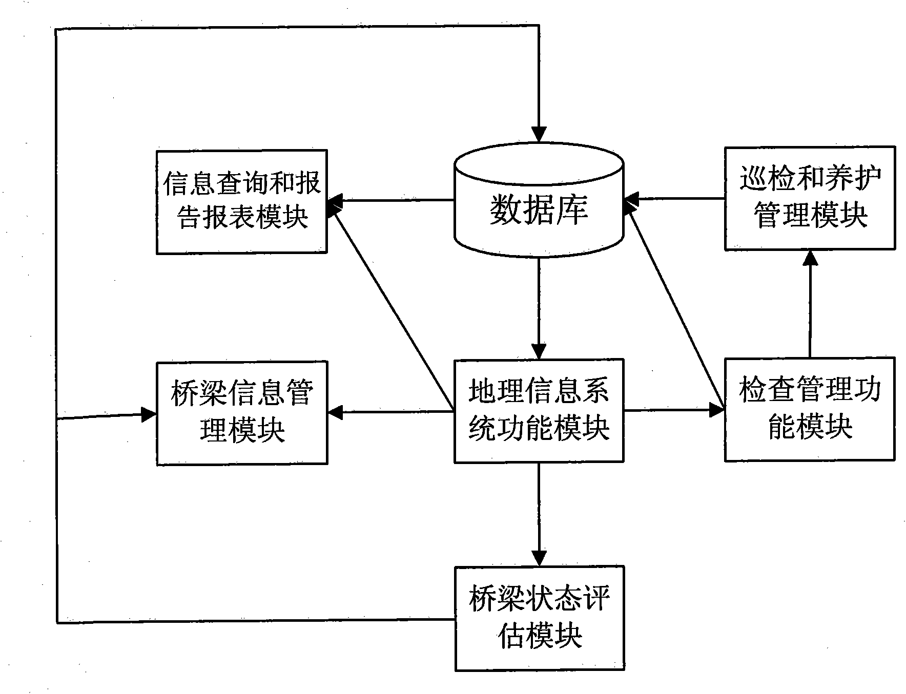
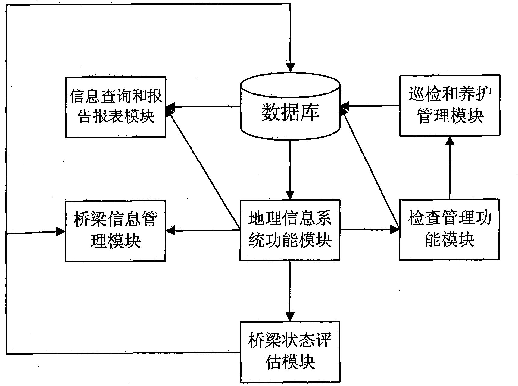
[0023] figure 1 It is the structure flow chart of this system, and its data interaction mode is shown by the arrow in the figure. The system is composed of sub-modules such as geographic information system function module, bridge information management module, inspection management function module, inspection and maintenance function module, bridge condition assessment module, information query and report report function module.
[0024] Among them, the geographic information system function module is used to comprehensively display and manage the situation, bridges and their information in the management area. This module is equipped with interfaces for other functional modules to facilitate function switching. The bridge information management module is used to query, edit and manage the detailed information of each bridge in the system management. The inspection management function module and the inspection and maintenance function module are used to manage and maintain the bridge. The inspection management function module is suitable for decision-makers to set, arrange, and review inspection and maintenance work. The patrol maintenance function module is used for task executors to carry out patrol inspection and maintenance tasks to receive, arrange, and record the results, evaluate, and submit. The bridge state assessment module is used to extract the current component information data and historical data from the database and estimate the current bridge health status and its future change trend based on a series of algorithms. The information query and report report function module is used for statistics and report generation of various bridge-related information stored in the system.
[0025] The bridge information management system provided by the present invention includes geographic information system function modules, bridge information management function modules, inspection management function modules, inspection and maintenance function modules, bridge condition evaluation function modules, information query and report report function modules, etc. The corresponding parts are composed.
[0026] In addition to the necessary software function modules, this system also requires a server to access external video monitoring servers and data monitoring servers to provide related WEB-based monitoring functions.
[0027] The GIS function module is a way to manage all bridges in a certain area based on GIS technology. It can comprehensively represent all bridges and their comprehensive parameters in the corresponding area, and visualize the conditions of the bridges in the range. The parameter setting of this module is universal, and its development based on GIS technology enables developers to make it suitable for other different areas or even larger areas as long as they make corresponding modifications. This module includes basic functions such as query, positioning, and eagle eye, and is connected with the bridge information management module, inspection management function module, inspection and maintenance function module, condition assessment function module, report report function module, etc. to achieve a bridge Its specific management functions.
[0028] The bridge information management module is a bridge information service method formulated in strict accordance with bridge-related specifications and standards. This module includes sub-modules such as bridge construction composition management, bridge information management, information option settings, bridge static information management, and bridge dynamic information management. Clicking on the control in this module will display bridge information such as corresponding attached photos, structure diagrams, parameter lists and historical records. You can add or delete components for the required bridge from the component library, and complete a series of operations such as setting parameters and structural drawings, so that the bridge information can be truly and comprehensively displayed. In the bridge static information management, all the static information that the bridge should have is provided, with pictures, structural diagrams and documentation to give more detailed instructions. The bridge dynamic information management includes inspection information, maintenance information, accident information, the current state of the bridge, and information about heavy vehicles crossing the bridge.
[0029] The inspection management function module is mainly for users to visually view the inspection plan for a certain day. Intuitively displayed on the calendar, and there are corresponding task links on the left and right. On the calendar, you can see which day and which bridge will be inspected and specific tasks. Managers can arrange tasks. In addition to viewing, the system also provides various forms of viewing of past inspection history and disease management functions.
[0030] The inspection and maintenance function module provides management services for the inspection plan of the bridge. The inspection part includes sub-modules such as my plan, schedule, project plan, and meeting management, and can assist in the completion of the inspection form template. It qualifies the diseases encountered during the inspection process and provides the corresponding maintenance measures for the managers, and can be automatically linked to the required maintenance costs. In this system, we have specially set up a measure library to serve this module.
[0031] The bridge condition assessment module is mainly responsible for checking the current condition assessment of the bridge, and using the Markov chain and other algorithms frequently used in the bridge industry to work together to calculate the future condition to realize the prediction of the future condition.
[0032] The information query and report report function module is used to query the bridge status and daily work with different query conditions according to the requirements of the manager and can independently customize the required statistical information to generate corresponding charts and reports. The reports can be passed by the administrator The will to choose the type.
[0033] In bridge information management, there are multiple data formats, and these data include spatial data, attribute data, and bridge management data. The amount of data is huge. In a sense, data is the basis and guarantee for the operation of the bridge information management system, reflecting the practical value of an information management system. The system adopts B/S architecture, which can well meet the requirements of bridge management for geographic information systems such as GIS, and make the system open and easy to expand. He divides the task into two parts: server-side and browser-side. The client can request data, analysis tools or modules from the server through the browser. The server executes the client's request and sends the results back to the client via the network, or sends data and analysis tools. Sent to the client for client use. Because WEB GIS applies the concept of B/S to perform GIS analysis tasks, it realizes the characteristics of high efficiency, operability, flexibility, timeliness, safety, fault tolerance, confidentiality, and scalability.
[0034] When the user manages the target bridge. The corresponding geographic information of the target bridge can be located on the geographic information map to locate the target bridge. The GIS map is equipped with an information management interface for all bridges in the area. If the user needs to manage the target bridge information, just use the GIS map Select according to the corresponding geographic information of the bridge or locate on the map through the target coordinates to switch to all the required management functions of the target, which greatly improves the convenience, accuracy and intuitiveness of finding and positioning the required management bridge, and realizes geographic The information map and the bridge information management function complement each other.
[0035] The system server is divided into WEB server, file server and DB server according to the system requirements. Whether the hardware can be separated or not can be determined according to the actual deployment needs. In the case of low load, the three can be deployed on the same server. The current database management system not only can manage the attribute data, but also the integrated management of graphic data and attribute data, especially the highly integrated integrated management of graphics, attributes, images, texts, etc., has been relatively complete. This makes the interface of the bridge information management system very friendly. The main functions provided by this system include GIS, news, bridge management, bridge maintenance management, evaluation and forecasting, query statistics, asset management, reports and other functions.
[0036] The users of this system include daily managers, senior managers, and task performers. The system sets different requirements and permissions for different users and system-related activities.
[0037] The GIS part of this system includes two main functions: one is the operation of electronic maps, which is based on the bridge spatial database to operate spatial data, which can realize the display of the map (including the setting of layers), map control, and map measurement. , Hawkeye and other functions.
[0038] The second is the query function. It is based on the bridge attribute database to query the bridge and component parameters. You can check the bridge ID in the bridge layer of the map, and transfer the value to the database to query related data. First query the data set of the bridge ID in the database, and then send the value back to the map for display
[0039] In the bridge information management of this system, we have completed the systematic and standardized collection of various bridge static and dynamic information, generated various bridge management data tables based on the input bridge-related information, and combined basic bridge data and inspection data to do The ability to monitor and evaluate the actual bearing capacity of the bridge, analyze the results of the bridge monitoring, and make repair and maintenance recommendations. The core content of our system is the batch management of bridge information within a certain range based on WEB GIS, so we set up bridge identification data, bridge structure data, bridge inspection data, bridge special inspection data, bridge maintenance data, and special events for it. A series of operational data such as data, bridge staff data, bridge file data, bridge maintenance equipment data, bridge condition data, etc., and completed the development of system functions around them, and realized the comprehensive collection, storage, and processing of various bridge data resources Function, users can quickly and accurately complete the bridge management function, and automatically generate various reports, realizing the bridge information management method.
[0040] The above provides a detailed introduction to the WEB GIS-based regional bridge information management system provided by the present invention. The principles and implementation methods of the present invention are explained using specific examples of use functions developed in this article.
[0041] The specific embodiments described above provide a further detailed description of the purpose, technical solutions and beneficial effects of the present invention. It should be understood that the above descriptions are only specific embodiments of the present invention and are not intended to limit the present invention. Any modification, equivalent replacement, improvement, etc., made within the spirit and principle of the present invention shall be included in the protection scope of the present invention.

PUM

no PUM

Description & Claims & Application Information

We can also present the details of the Description, Claims and Application information to help users get a comprehensive understanding of the technical details of the patent, such as background art, summary of invention, brief description of drawings, description of embodiments, and other original content. On the other hand, users can also determine the specific scope of protection of the technology through the list of claims; as well as understand the changes in the life cycle of the technology with the presentation of the patent timeline. Login to view more.

Similar technology patents

Dust storage and separation equipment for gravel conveyor

Owner:遂宁明强商品混凝土有限公司

Classification and recommendation of technical efficacy words

Why Eureka
Try Eureka