Method for manufacturing digital elevation model by using data of laser altimeter

A technology of digital elevation model and laser altimeter, which is applied in image data processing, calculation, 3D modeling, etc., can solve the problems of altimetry data containing errors, distortion, and not considering various errors of data, etc., and achieve data accuracy and resolution Improved effect

Inactive Publication Date: 2011-01-19
NAT ASTRONOMICAL OBSERVATORIES CHINESE ACAD OF SCI
View PDF2 Cites 22 Cited by
  • Summary
  • Abstract
  • Description
  • Claims
  • Application Information

AI Technical Summary

Problems solved by technology

[0004] However, due to errors in many links such as instrument system noise, lunar surface terrain fluctuations, satellite orbit and attitude measurement, etc., the original altimetry data of LAM inevitably contain errors
Data errors in the process from raw data to DEM processing will be propagated and amplified, resulting in obvious elevation singularities in the altimetry data, and even severe distortion and distortion
[0005] In the process of preparing the lunar DEM in the existing technology, on the one hand, the data used is only the data of the lunar front, and on the other hand, various errors in the data are not considered, which makes the produced lunar DEM inaccurate and incomplete

Method used


Image

  • Method for manufacturing digital elevation model by using data of laser altimeter
  • Method for manufacturing digital elevation model by using data of laser altimeter
  • Method for manufacturing digital elevation model by using data of laser altimeter

Examples


Embodiment Construction

[0034] In order to make the object, technical solution and advantages of the present invention clearer, the present invention will be described in further detail below in conjunction with specific embodiments and with reference to the accompanying drawings.

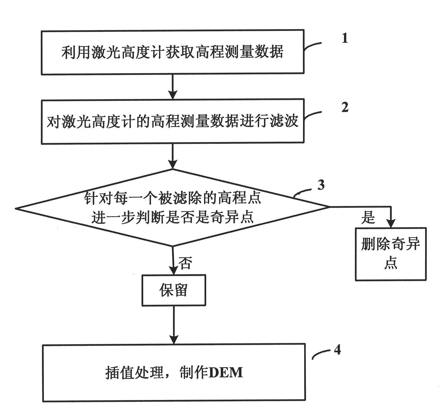
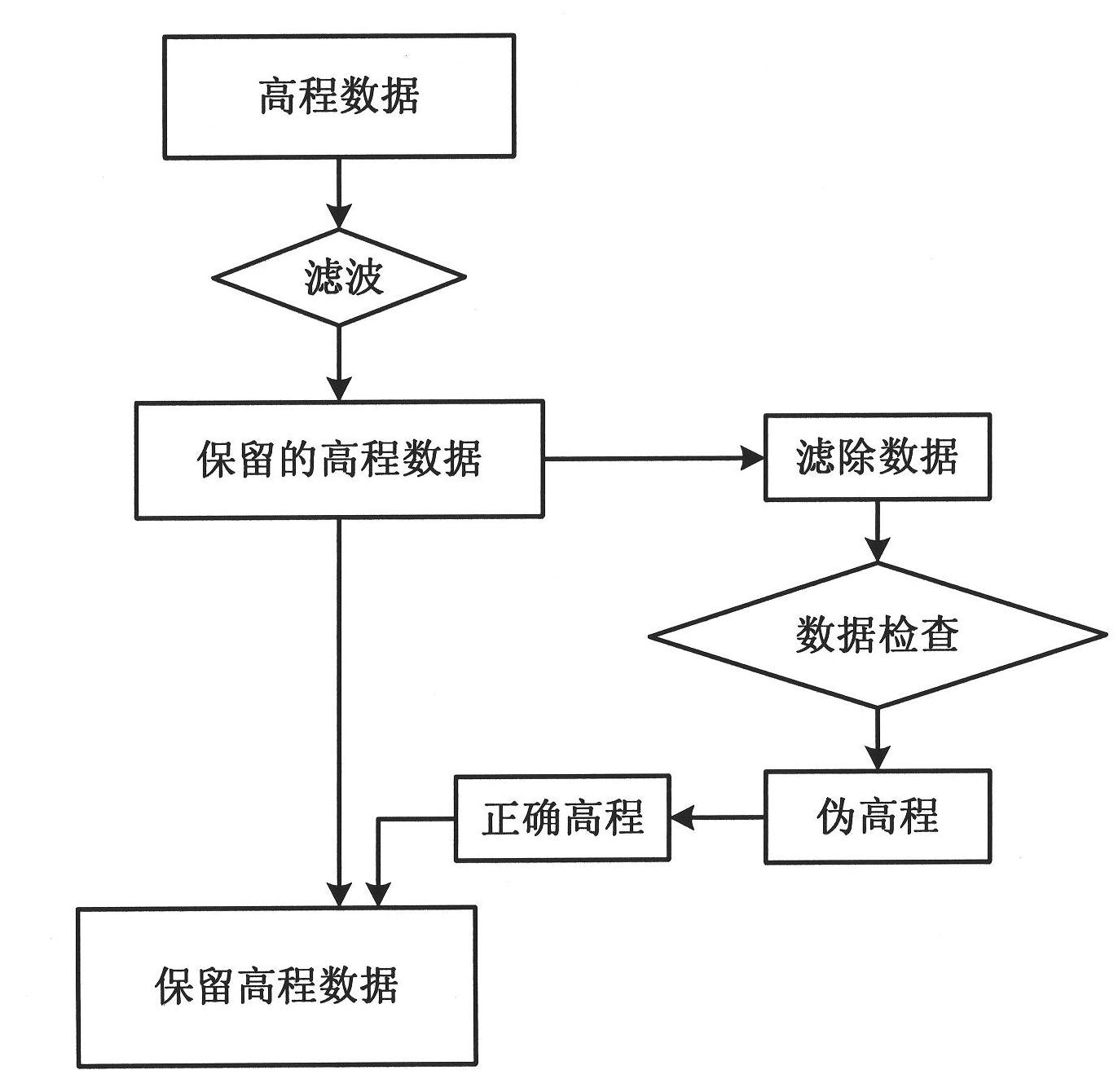
[0035] refer to figure 1 Shown flow chart, the method that utilizes laser altimeter product data of the present invention to make lunar DEM comprises:

[0036] (1) Obtain elevation measurement data.

[0037] The laser altimeter mounted on the lunar exploration satellite is an important payload to obtain three-dimensional images of the lunar surface, and this type of laser altimeter can measure the distance from the satellite to the substellar point on the lunar surface on the one hand, and provide a digital elevation model of the lunar surface on the other hand DEM radial height data.

[0038] The basic principle of the laser altimeter to obtain data is to launch a beam of high-power narrow laser pulses from the satelli...


PUM


Abstract

The invention discloses a method for manufacturing a digital elevation model by using data of a laser altimeter. The method comprises the following steps of: acquiring elevation measurement data by using the laser altimeter; filtering the elevation measurement data of the laser altimeter; and filtering, and interpolating the laser elevation measurement data subjected to singular point removal, and manufacturing the digital elevation model (DEM) with full moon regular grids. Because full moon data is used, the data accuracy and the resolution of the moon DEM manufactured by using the method are obviously increased by using the filtering and interpolating process.

Description

technical field [0001] The invention relates to a method for making digital topographic maps, in particular to a method for making numbers by using laser altimeter data. Background technique [0002] Early aerospace laser altimeter systems included laser altimeters mounted on Apollo aircraft in the 1970s, and laser altimeters launched in recent years include SLA (Shuttle Laser Altimeter) and MOLA (Mars Orbital Laser Altimeter), which can obtain meter-level accuracy of the earth and terrain data for Mars. In lunar topographic mapping, high-precision lunar surface elevation measurements are obtained through laser ranging technology. At present, only American Clementine, Apollo 15, Apollo 16, Apollo 17, Japan's SELENE and my country's "Chang'e-1 (CE-1)" satellite have carried out laser ranging on the lunar surface; only the laser detection data of SELENE and CE-1 have covered full moon. In addition, Archinal et al. used the Clementine laser altimeter and UVVIS image data to m...

Claims


Application Information

Patent Timeline
Patent Type & Authority Applications(China)
IPC IPC(8): G06T17/05
Inventor 邹小端任鑫刘建军牟伶俐李春来
Owner NAT ASTRONOMICAL OBSERVATORIES CHINESE ACAD OF SCI
Why Eureka
Try Eureka