Method and system for three-dimensional terrain modeling

A technology of three-dimensional terrain and modeling method, applied in the field of GIS, can solve the problem of illumination model affecting system efficiency, etc., and achieve the effect of improving system efficiency

Inactive Publication Date: 2015-02-18
CHINA DIGITAL VIDEO BEIJING
View PDF2 Cites 0 Cited by
  • Summary
  • Abstract
  • Description
  • Claims
  • Application Information

AI Technical Summary

Problems solved by technology

[0005] The technical problem to be solved by the present invention is to provide a three-dimensional terrain modeling method and system to solve the problem that the self-built illumination model affects the system efficiency

Method used


Image

  • Method and system for three-dimensional terrain modeling
  • Method and system for three-dimensional terrain modeling
  • Method and system for three-dimensional terrain modeling

Examples


Embodiment Construction

[0052] In order to make the above objects, features and advantages of the present invention more comprehensible, the present invention will be further described in detail below in conjunction with the accompanying drawings and specific embodiments.

[0053] Since the D3D three-dimensional engine provides simulations such as modeling and lighting, which well meet the requirements for making three-dimensional terrains, the present invention uses the D3D three-dimensional engine to build a three-dimensional model without the need to build a lighting model by itself, which improves system efficiency.

[0054]Among them, Direct 3D (D3D) is a display program developed by Microsoft to improve the display performance of 3D games in WIN 95 / 98, and is a 3D graphics API based on Microsoft's Common Object Mode COM (Common ObjectMode).

[0055] The following will be described in detail through examples.

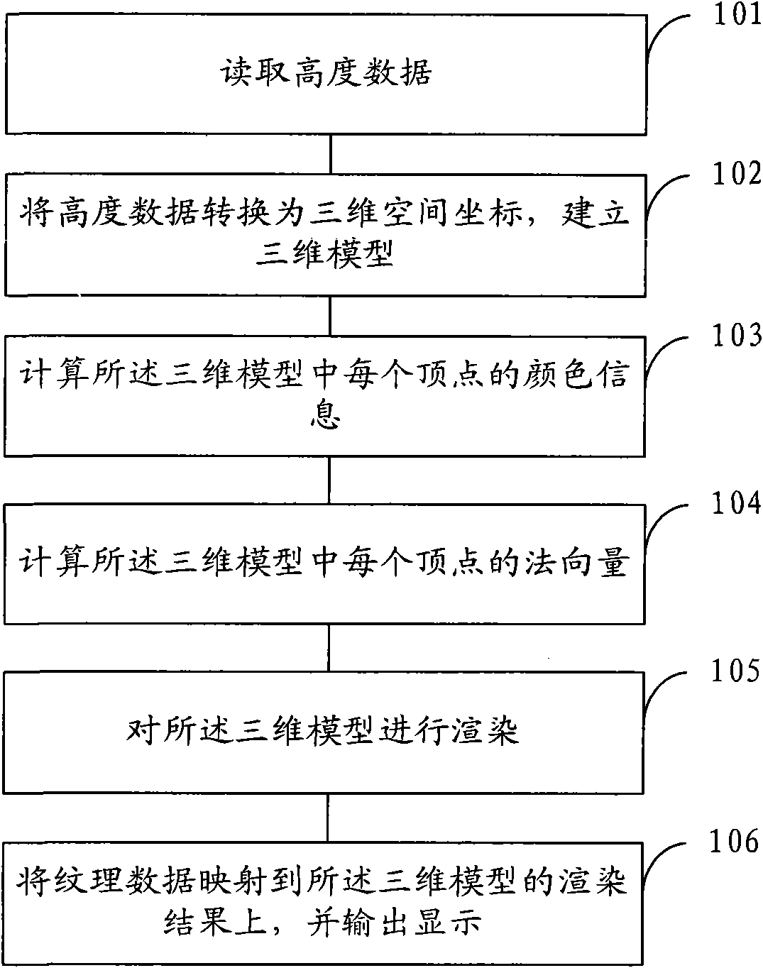
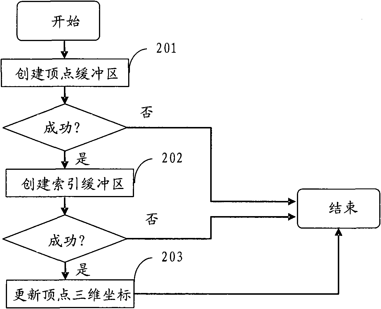
[0056] refer to figure 1 , is a flowchart of a three-dimensional terrain modeling me...


PUM


Abstract

The invention provides a method and a system for three-dimensional terrain modeling. The method comprises the following steps: reading altitude data; converting the altitude data to three-dimensional space coordinates and constructing a three-dimensional model; calculating the color information and normal vector of each vertex in the three-dimensional model; and rendering the three-dimensional model. By using a D3D (display 3-dimensional) three-dimensional engine for constructing the three-dimensional engine, the method can well meet the requirement of the three-dimensional terrain because the D3D three-dimensional engine can simulate modeling, illumination and the like, thereby omitting the construction of an illumination model and improving the system efficiency.

Description

technical field [0001] The invention relates to the technical field of GIS, in particular to a three-dimensional terrain modeling method and system. Background technique [0002] GIS, or Geographic Information System, is a computer-based tool that maps and analyzes what exists and what happens on Earth. GIS technology integrates the unique visual effects and geographic analysis functions of maps with general database operations (such as query and statistical analysis, etc.). This capability distinguishes GIS from other information systems, making it useful for interpreting events, predicting outcomes, planning strategies, etc. among a wide range of public and individual enterprises and institutions. GIS is widely used in resource investigation, environmental assessment, disaster prediction, land management, urban planning, post and telecommunications, transportation, military public security, water conservancy and electric power, public facilities management, agriculture, f...

Claims


Application Information

Patent Timeline
Patent Type & Authority Patents(China)
IPC IPC(8): G06T17/00
Inventor 胡守刚
Owner CHINA DIGITAL VIDEO BEIJING
Why Eureka
Try Eureka