RPC-based method for improving and calibrating block adjustment of three-linear array three-dimensional satellite

A technology of block adjustment and three-line array, which is applied to the interpretation of photos, measuring devices, instruments, etc., can solve the problems of loss of accuracy and inability to check the parameters of three-line array cameras, etc.

Active Publication Date: 2011-08-31
CHINA CENT FOR RESOURCES SATELLITE DATA & APPL
View PDF4 Cites 28 Cited by
  • Summary
  • Abstract
  • Description
  • Claims
  • Application Information

AI Technical Summary

Problems solved by technology

The development of the three-line array stereo camera highlights the limitations of the RPC adjustment method of the traditional push-broom camera. It cannot well reflect the advantages of the three-line array stereo camera in terms of geometric accuracy in the adjustment method. It is not associated with the camera, so it is impossible to check the parameters of the three-line array camera, further loss of accuracy

Method used


Image

  • RPC-based method for improving and calibrating block adjustment of three-linear array three-dimensional satellite
  • RPC-based method for improving and calibrating block adjustment of three-linear array three-dimensional satellite
  • RPC-based method for improving and calibrating block adjustment of three-linear array three-dimensional satellite

Examples


Embodiment Construction

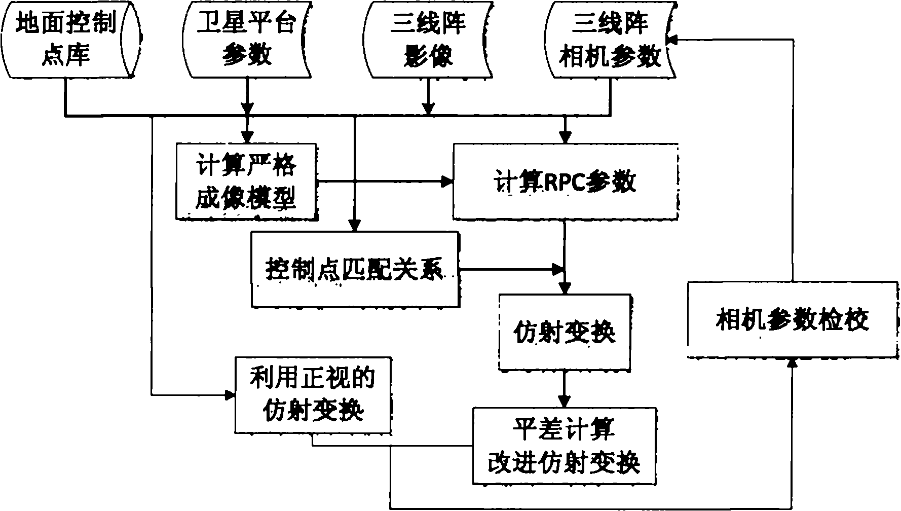
[0042] Attached below figure 1 The inventive method is described in detail, specifically as follows:

[0043] (1) The orbit of the satellite is extracted from the auxiliary data downloaded by the satellite (X ob , Y ob ,Z ob ) and gesture And determine the projection relationship between the ground point and the image point according to the extracted orbit and attitude of the satellite, that is, the strict imaging model;

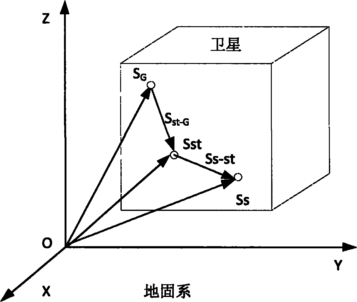
[0044] The coordinate value (X ob , Y ob ,Z ob ), that is, the GPS phase center S G Coordinates under the ground-fixed system, satellite barycenter S ST and Camera Station Center S S The relationship between figure 2 Shown:

[0045] Obtain the coordinate S of the center of the camera station under the ground solid system S , calculated as follows:

[0046] S S= S ST +S S-ST = S G +S ST-G +S S-ST (1)

[0047] Among them, S ST-G is the installation value from the GPS phase center to the satellite body, S S-ST It is the installation ...


PUM


Abstract

The invention relates to a rational-polynomial-coefficients (RPC)-based method for improving and calibrating the block adjustment of a three-linear array three-dimensional satellite, which comprises the following steps of: (1) determining the mapping relationship between ground points and image points, namely a strict imaging model; (2) solving RPC parameters of each image in three linear arrays according to the strict imaging model, and searching for connection points among the three linear arrays by image matching; (3) listing three affine transformation formulas of fore sight, front sight and back sight of the three-linear array images; (4) establishing an error equation and solving to acquire corrections of affine transformation parameters, and revising the affine transformation formulas by utilizing the corrections; (5) listing the affine transformation formulas of the fore sight and the back sight again by utilizing camera parameters and the revised affine transformation formula of the front sight; and (6) solving the revised affine transformation formulas of the fore sight and the back sight in the step (4) and the listed affine transformation formulas of the fore sight and the back sight in the step (5) simultaneously to acquire the corrections of the camera parameters, and revising the camera parameters to improve and calibrate the block adjustment of the three-linear array three-dimensional satellite.

Description

technical field [0001] The invention relates to an improvement and checking method of block adjustment of three-line array three-dimensional satellite images, which can be used for processing various high-precision three-line array three-dimensional satellite images. Background technique [0002] The high-resolution earth observation system is an important strategic resource and infrastructure of the country. The three-line array stereoscopic mapping satellite is a kind of high-precision earth observation satellite. The three-line array camera and its platform have high resolution, high geometric positioning accuracy and Features of Stereo Imaging. However, since the imaging accuracy of the three-line array camera is closely related to the accuracy of the satellite platform, and the relationship between the three-line arrays also needs to be further corrected by ground processing, the high-precision ground processing method is particularly important. The three-line array th...

Claims


Application Information

Patent Timeline
Patent Type & Authority Applications(China)
IPC IPC(8): G01C11/04G01C25/00
Inventor 钟慧敏徐文喻文勇陈琦康倩李庆鹏刘明亮
Owner CHINA CENT FOR RESOURCES SATELLITE DATA & APPL
Why Eureka
Try Eureka