Method for optimizing land use evolution CA model transformation rules
An optimization method and model conversion technology, applied in the field of geographic information science, can solve problems such as large amount of calculation, complex operation, slow convergence speed, etc., to achieve the effect of improved operating efficiency and accuracy, high simulation accuracy, and fast convergence speed
- Summary
- Abstract
- Description
- Claims
- Application Information
AI Technical Summary
Problems solved by technology
Method used
Image
Examples
Embodiment Construction
[0027] specific implementation
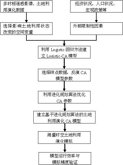
[0028] The implementation of the technical solution will be further described in detail below with reference to the accompanying drawings.
[0029] like figure 1 As shown, the concrete flow process of the present invention is as follows:
[0030] The first step is to analyze the spatial data of different phases, and combine the actual situation of the area to select the factors that affect the change of land use in the area, such as the distance from the city center, the distance from the main road, etc.
[0031] The second step is to establish a Logistic-CA model, whose state function is
[0032] (1)
[0033] where i and j are the row and column numbers of the cell, respectively, and are the states of the cell (i, j) at time t+1 and time t, respectively, is the state function of the neighborhood cell at time t, and N is the number of cells in the neighborhood, including the central cell.
[0034] (2)
[0035...
PUM
 Abstract
Description
Claims
Application Information
 - R&D
- Intellectual Property
- Life Sciences
- Materials
- Tech Scout
- Unparalleled Data Quality
- Higher Quality Content
- 60% Fewer Hallucinations
Browse by: Latest US Patents, China's latest patents, Technical Efficacy Thesaurus, Application Domain, Technology Topic, Popular Technical Reports.
© 2025 PatSnap. All rights reserved.Legal|Privacy policy|Modern Slavery Act Transparency Statement|Sitemap|About US| Contact US: help@patsnap.com


