Method for evaluating influence of information hiding capacity on measurement precision of remote sensing image

A remote sensing image and evaluation information technology, applied in image analysis, image data processing, image data processing, etc., can solve the problems of photogrammetry and remote sensing application research without in-depth reports, remote sensing image fuzziness, unmanned research, etc.

Inactive Publication Date: 2011-11-09
耿则勋
View PDF1 Cites 4 Cited by
  • Summary
  • Abstract
  • Description
  • Claims
  • Application Information

AI Technical Summary

Problems solved by technology

[0007] 5. Rich texture structure and complex feature structure;
[0008] 6. There is no obvious subject feature information, the information content is complex, and due to the limitations of the sensor's spatial resolution and spectral resolution, remote sensing images have a certain degree of ambiguity and ambiguity;
[0012] Looking at the research status of information hiding at home and abroad, although many results have been obtained, so far no research has been done on information hiding for digital geospatial data to maintain measurement and positioning accuracy. There is no in-depth report on applied research; due to the complexity of remote sensing image representation and the particularity of application requirements, it is required that the impact of information storage capacity on its quality must meet the accuracy requirements, that is, the "nearly lossless" requirement, which refers to the impact of hidden information on remote sensing The influence of the image application effect is measurable, that is, as long as the maximum distance (or the maximum difference of pixel value) between each pixel of the remote sensing image containing hidden information and the corresponding pixel on the original remote sensing image is within the maximum error threshold , it is considered that the data accuracy is acceptable. If the threshold is small enough, it is considered that the application results of the processed remote sensing image and the original remote sensing image are extremely close; therefore, how to evaluate the relationship between remote sensing image data measurement and The quality of positioning, how to design an information hiding algorithm that maintains measurement and positioning accuracy, and how to evaluate the relationship between information hiding capacity and remote sensing image measurement and positioning accuracy, so as to provide copyright protection, secure distribution, attack detection, authorized access, and Provide effective technical support for accountability and better promote the construction of geospatial information infrastructure, which has important research value

Method used


Image

  • Method for evaluating influence of information hiding capacity on measurement precision of remote sensing image
  • Method for evaluating influence of information hiding capacity on measurement precision of remote sensing image
  • Method for evaluating influence of information hiding capacity on measurement precision of remote sensing image

Examples


Embodiment Construction

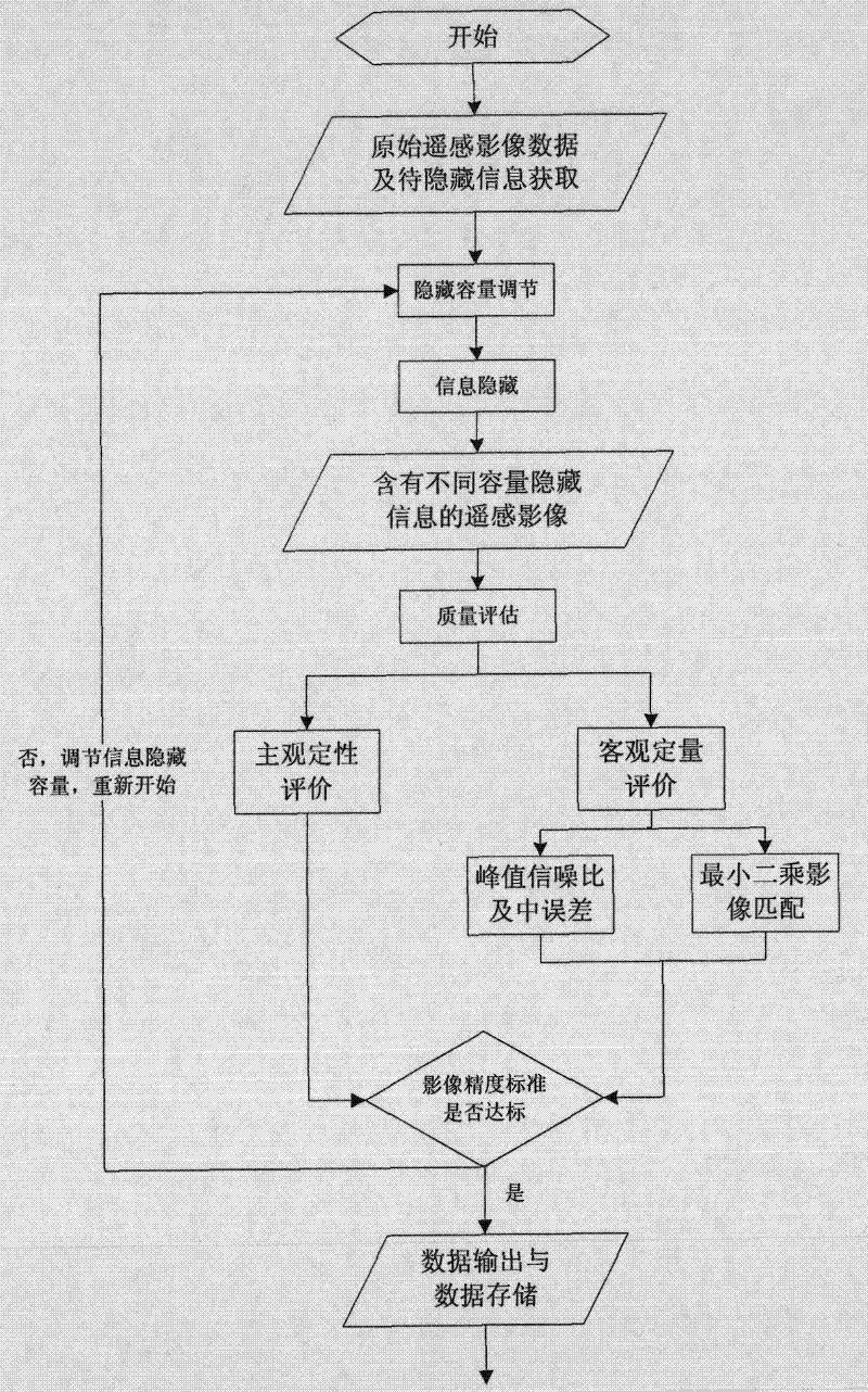
[0070] The invention provides a method for evaluating the impact of information hiding capacity on the measurement accuracy of remote sensing images, such as figure 1 As shown, the specific steps are as follows:

[0071] 1), obtain the experimental data, the experimental data includes the original carrier remote sensing image, the information to be hidden, and put the obtained data into the designated system data storage area; after that, enter step 2);

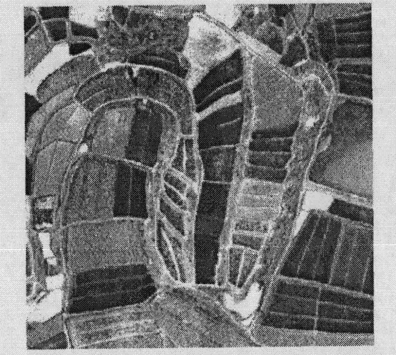
[0072] Wherein, the original carrier remote sensing image is a ground remote sensing image obtained from a satellite application ground station. In this embodiment, the selected data is a digital image in *.bmp format with a size of 256×256 pixels, such as figure 2 shown; (in addition to digital images in *.bmp format, digital images in other formats such as *.tif, *.jpg, etc. can also be used, not limited to *.bmp format);

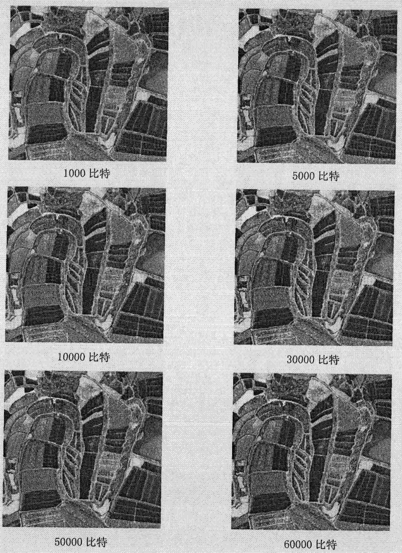
[0073] The information to be hidden is a [0, 1] random sequence (a random sequence composed of 0, 1...


PUM


Abstract

The invention provides a method for evaluating an influence of information hiding capacity on the measurement precision of a remote sensing image. The method comprises the following steps of: performing information hiding with different capacities on data of the remote sensing image of the original carrier by a remote sensing image information hiding method based on a Forstner characteristic point, and objectively and quantitatively evaluating the quality of the remote sensing image subjected to the information hiding; and evaluating the influence of the information hiding capacity on the measurement precision of the remote sensing image by a least square matching method. Therefore, an objective and accurate reference standard is provided for design of a better information hiding algorithm; and the method is high in practical value.

Description

technical field [0001] The invention belongs to the field of digital signal and digital image processing, and in particular relates to a method for evaluating the influence of information hiding capacity on the measurement accuracy of remote sensing images; Background technique [0002] With the development of remote sensing platform and remote sensor imaging technology, the acquisition of remote sensing images has become more and more convenient, and has gradually become one of the important information sources for geospatial information data acquisition in the 21st century; general images are only a similarity to objective objects Imitation or description is an incomplete, imprecise but appropriate representation in a certain sense, and it is a highly concentrated and generalized representation of objective object information; as a "Picture" (photo, picture), an ordinary image only needs to satisfy Visual needs, and remote sensing images, in addition to being "Picture" (ph...

Claims


Application Information

Patent Timeline
Patent Type & Authority Applications(China)
IPC IPC(8): G06T7/00G06T1/00G01S7/48
Inventor 耿则勋王兰王振国杨阳宋向陈路魏小峰王洛飞
Owner 耿则勋
Why Eureka
Try Eureka